Relict Marine Sor Between Alexanderbay Bay and the Depressions of Mangyshlak –
Ashchysor Depression (also known as Ashchysor, from the Turkic words "ashchy" – bitter and "sor" – dried salt lake) is a grand endorheic salt basin in the Mangistau Region. Hundreds of millions of years ago, this entire territory was part of the deep-water prehistoric Tethys Ocean. As a result of tectonic movements, the retreat of the ancient ocean, and subsequent cycles of level fluctuations of the isolated Caspian basin, a thick bed of mineral salt deposits formed here.
The bottom horizons of Ashchysor are composed of mirabilite, halite, and sodium sulfate, whose chemical composition is virtually identical to the legendary salts of the Kara-Bogaz-Gol Gulf. The basin consists of two adjacent hollows separated by a rocky stone ridge: a smaller one (Upper Ashchysor), adjoining the sea, and a vast main hollow (Lower Ashchysor), spreading across the depths of the desert plateau.
In the expedition geography and tourist logistics of Mangyshlak, the Ashchysor Depression occupies a strategic position at the junction of the seacoast and the deep canyons of the Karakiyan District. The depression is situated just 1.5 km east of Alexanderbay Bay and literally 2 km west of one of the deepest depressions in the world – the colossal Karagiye Depression.
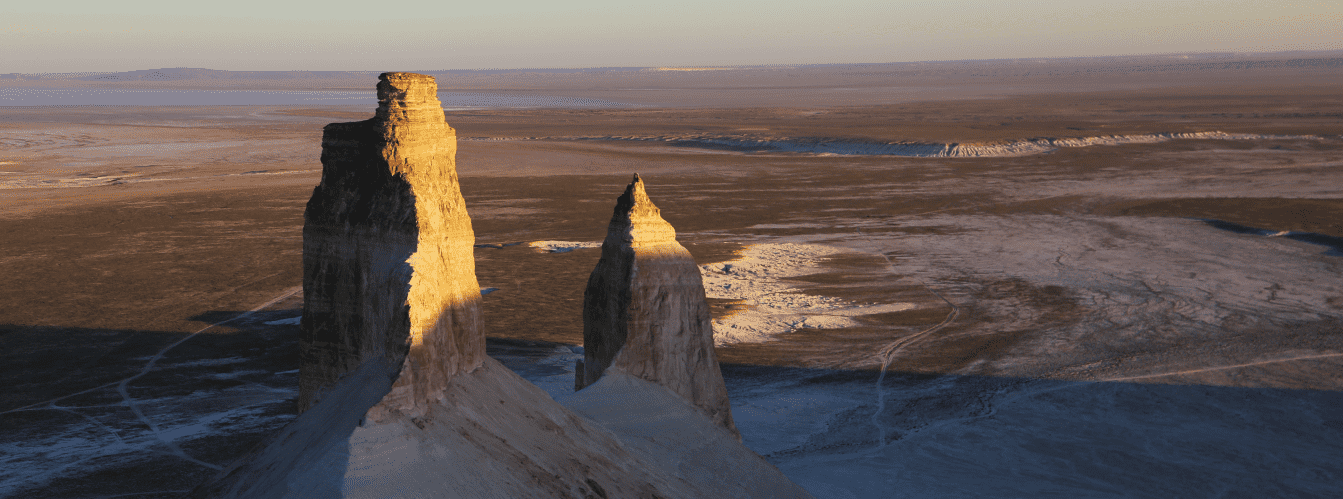
Traveling south from the regional center of Aktau toward the ferry port of Kuryk, road travelers consistently cross these salt wastes. From here, direct off-road routes open up to other iconic natural monuments of the region: the coastal Saura Gorge with relict Lake Karakup, the deep Samal Canyon, Cape Peschany, the picturesque Karynzharyk Depression with the "Three Brothers" buttes, the chalk cliffs of the Bozjyra Tract, Tuzbair Salt Flat, and the sands of Senek Village.
Today, the Ashchysor Depression stands at the center of major geopolitical, infrastructural, and hydrotechnical initiatives. Separated from the Caspian Sea by a sand-and-shell spit between 4 and 15 km wide, the depression is envisioned as the base for creating the colossal "Inzhu-Marzhan" marine resort cluster, a deep-water dry port terminal, and a unique hydroelectric power system closing the outflow into the Karagiye basin. Further east lie the Kuandy Depression and the Basgurly – Zhazgurly depression system.
The wild, pristine beauty of sparkling salt crystals, the Martian-like landscape, and proximity to the Caspian make Ashchysor a must-see location for enthusiasts of extreme tourism and geoecology.
--------------------------------------------
How to Get There and Visit –
The Ashchysor Depression is located in the southwestern part of the Mangyshlak Peninsula within the territory of the Karakiyan District in the Mangistau Region. The basin extends parallel to the coastline of the Caspian Sea between Alexanderbay Bay and the western rim of the Karagiye Depression. The distance from the city of Aktau to the northern limits of the sor is about 55–65 km, from the district center and the Kuryk Ferry Complex around 18–25 km, and from the town of Zhanaozen about 110–120 km.
GPS geographic coordinates of the central part of the Ashchysor Depression:
43°15'17"N 51°29'52"E
The route from the city of Aktau heads south along the national paved highway Aktau – Kuryk. After covering about 50–55 km of high-quality asphalt toward Alexanderbay Bay, turn east onto well-worn steppe dirt tracks running along the rocky ridge between Upper and Lower Ashchysor (another 6–10 km across the steppe). The total driving time from Aktau by car is approximately 1–1.5 hours.
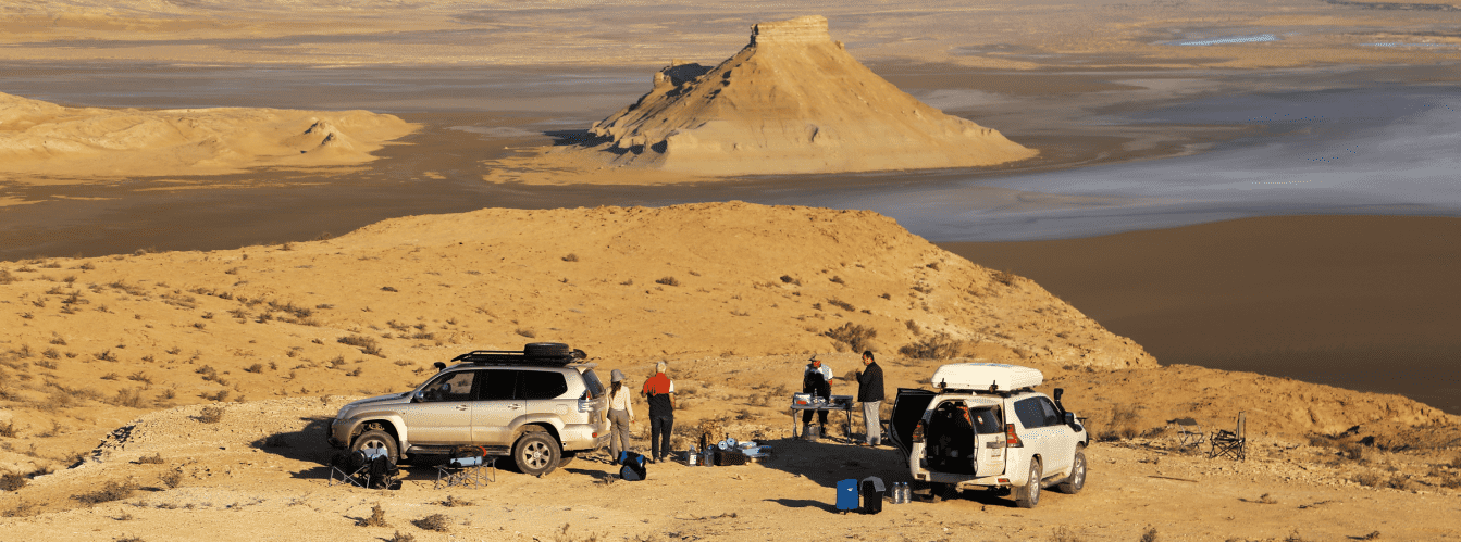
Access roads and terrain passability: the coastal turnoffs and the highway toward the port of Kuryk can easily be reached in any passenger vehicle. However, driving around the perimeter of the salt basins, navigating the sand drifts of the coastal spit, and negotiating rocky ridges strongly calls for a four-wheel-drive 4x4 SUV with a ground clearance of 200–220 mm.
Driving directly onto the salt crust floor of the depression is STRICTLY PROHIBITED: beneath the deceivingly firm white crust of salt lies deep, viscous mud and black sulfuric silt, in which heavy vehicles bog down instantly. An expedition vehicle should be equipped with all-terrain or mud tires (AT/MT), a kinetic snatch strap, shackles, an air compressor, and sand ladders (recovery tracks).
Walking tours and safety procedures: viewing the salt flat is conducted from solid shoreline terraces and the rocky dividing ridge. When stepping onto the salt crust of Upper Ashchysor, extreme caution must be exercised: salt crystals are very hard and sharp, and under a thin layer of brine, footwear can easily become soaked with caustic salt solution.
Walking barefoot or in light fabric footwear is forbidden to prevent chemical skin burns and injury. Durable trekking boots with water-repellent coating or rubber boots are essential.
Environmental safety rules: the natural systems of Ashchysor and the neighboring Karagiye Depression are unique, fragile ecosystems of the Caspian region.
Within the boundaries of the Ashchysor Depression, it is STRICTLY FORBIDDEN to:
– drive wheeled vehicles onto the surface of the salt flat, destroying the salt crust and leaving deep ruts in the brine;
– pollute the basin and adjacent sandbar with household litter, plastic, and tin cans;
– discharge vehicle fluids, oils, or fuel onto the ground;
– light open campfires outside designated grills during strong coastal winds;
– damage the fragile ledges of the sand-and-shell spit;
– cause disturbance or harm to rare colonies of flamingos and wetland birds during spring water surges.
Infrastructure: the Ashchysor Depression lies in an uninhabited semi-desert zone. The nearest modern gas stations, supermarkets, hotels, pharmacies, and tire shops are located in the settlement of Kuryk (18–25 km to the southeast) and in the city of Aktau (55–65 km to the north).
Setting up an autonomous field camp on the rocky terraces requires full self-sufficiency: drinking water calculated at a minimum of 3 liters per person per day, a supply of fresh utility water to wash salt from shoes, wind-resistant tents with heavy-duty stakes (continuous sea breezes blow inland), and sunshades.
Cellular reception on the elevations surrounding the depression is reliable due to the proximity of the Kuryk highway, though signals can drop within the deeper parts of the basin.
Best time to visit is spring and autumn. The period from mid-April to early June is the most favorable: seeped marine waters create temporary shallow mirror lagoons that draw migratory birds, while temperatures hold around +18...+24 °C. September and October offer dry, calm weather, clear skies, and complete drying of the salt crust in Lower Ashchysor, transforming it into a snow-white desert. In July and August, temperatures exceed +38...+42 °C, and intense brine evaporation produces heavy, humid, salt-laden air within the basin.
--------------------------------------------
History
The history of research and exploration in the Ashchysor Depression is closely intertwined with the development of Caspian cartography, Peter the Great's expeditions, and geopolitical projects of both Soviet and modern Kazakhstan.
In ancient times, as the Tethys Ocean desiccated and the Caspian basin took shape, Ashchysor existed as a permanent marine bay. Historical records show that into the early 18th century, the depression maintained an open hydrological connection with the sea, and in 1764 it formed a single water body with Alexanderbay Bay.
The first instrumental mapping of the basin on Russian imperial charts occurred in 1715 during Prince Alexander Bekovich-Cherkassky's Caspian expedition, where it was charted under the name "Oseter Bay". Over a century later, in 1832, prominent naturalist and Mangyshlak explorer G. S. Karelin completed a detailed topographical survey of the bay and renamed it after E. F. Kankrin, then Minister of Finance of the Russian Empire. However, the hydronym "Kankrin Bay" did not take root in popular toponymy.
By the end of the 19th century, driven by secular fluctuations of the Caspian Sea level, the sea channel became blocked by a sand-and-shell ridge, transforming the water body into an isolated lake. During that period, official records reference it under the sacred name Benturli-Ishan, meaning "the supreme spiritual figure of the Mangyshlak Turkmens" in Turkic. Throughout the 20th century, cyclic transgressions and regressions of the Caspian repeatedly caused Ashchysor to lose and regain its link with the sea.
In the mid-20th century, Soviet geographer and hydraulic engineer S. Yu. Geller proposed an ambitious project: excavate a canal from the Caspian Sea into Ashchysor and direct the marine flow onward into the Karagiye Depression, whose floor lies at -132 m below sea level. The colossal elevation drop would enable the operation of a hydroelectric power plant with a capacity of 35,000 kW. Under Geller's plan, ongoing water evaporation within the Karagiye bowl would maintain continuous pressure for hydroelectric turbines, while the evaporation basins of Ashchysor would precipitate concentrated brine, intended for industrial extraction of mirabilite and sodium sulfate as an alternative to Turkmen Kara-Bogaz-Gol.
In the 21st century, the concept of transforming Ashchysor gained fresh momentum. In 2017, a project surfaced to flood the depression to build an artificial inland sea and tourism riviera. In May 2022, President of Kazakhstan Kassym-Jomart Tokayev designated the "Inzhu-Marzhan" Caspian resort development as a key driver of international tourism in Central Asia. In December 2022, Academician Serik Burkitbayev presented an expanded concept for a multifunctional hub: plans for a deep-water dry port, oil tanker docks, fishery and rail clusters, and a subsequent phase constructing a pumped-storage power plant between Ashchysor and Karagiye. Active scientific discussions remain underway with ecologists assessing how hydraulic engineering works might affect the Caspian water balance, mirabilite salt transfer, and protected ecosystems of Lake Karakol and the Karagiye-Karakol Nature Sanctuary.
Information
Genetically and physiographically, the Ashchysor Depression is an erosional-deflational and tectonic coastal depression formed on the Neogene sedimentary basement of the Turan Plate at the bottom of the ancient Tethys Ocean. The basin floor lies below global sea level and is composed of heavy clay, loam, and sandy-salt deposits left by the New Caspian and Khvalynian transgressions.
The relief of the depression is clearly differentiated into two isolated hollows partitioned by a rocky bedrock ridge:
• Upper Ashchysor – the smaller western hollow, situated immediately adjacent to the shoreline of Alexanderbay Bay. Due to filtration and subsurface seepage of sea water through the 4–15 km wide sand spit, shallow, highly saline water bodies form here in spring and early summer, drying out completely by August;
• Lower Ashchysor – the primary eastern hollow, covering expansive areas extending toward the Karagiye Depression. It represents a classic dry sor covered by a thick, naturally precipitated salt crust ranging from several centimeters to half a meter in thickness.
The chemical composition of Ashchysor salts is exceptionally rich, categorized under the sulfate-chloride sodium-magnesium type. The primary mineral component is mirabilite (Glauber's salt, Na2SO4 · 10H2O), alongside thenardite, halite (rock salt), and epsomite. The density of crystalline salt deposits ranges between 1.48 and 2.16 g/cm3. Salinity of the residual brine during peak evaporation exceeds 300–350 g/L.
The regional climate is extremely arid, sharply continental with maritime influences. Winters are mild yet windy, with average January temperatures hovering around -2...-4 °C. Summers are long, drought-prone, and very hot: average July temperatures range from +27 to +30 °C, and on the dazzling white surface of the salt flat under direct sun, the ground heats up to +55...+60 °C. Annual atmospheric precipitation is minimal – no more than 120–140 mm per year, whereas potential evaporation exceeds this figure roughly tenfold.
Detailed Description of the Site
The natural, hydrological, and landscape complex of the Ashchysor Depression includes the following characteristic features:
• Lower Ashchysor salt basin – a vast, snow-white salt field composed of thick beds of naturally precipitated mirabilite and halite, gleaming under the sun like an ice sheet;
• Upper Ashchysor lagoon hollow – a seasonally flooded depression fed by filtered seawater from Alexanderbay Bay, creating striking mirror-like shallows;
• Rocky dividing ridge – a bedrock ridge of Tethys limestone and marl strata separating the two basins, serving as a natural viewing terrace;
• Coastal sand-and-shell spit – a natural coastal barrier between 4 and 15 km wide isolating the depression from direct waves of the Caspian Sea and Alexanderbay Bay;
• Inzhu-Marzhan hydraulic engineering project zone – level coastal plains designated in the master plan for dry docks of a deep-water port and a tourist cluster;
• Western structural cliffs of Karagiye – steep denudational escarpments and buttes separating the eastern edge of Ashchysor from the giant Karagiye Depression.
Flora and Fauna
Vegetation cover of the Ashchysor Depression and its rocky slopes is extremely sparse, formed by specialized halophytes and psammophytes capable of tolerating extreme salt concentrations. Higher plants do not grow directly on the salt crust. Along the basin margins and across salt takyrs, one finds Halocnemum strobilaceum, glasswort (Salicornia europaea), Caspian saltwort, Kalidium caspicum, and Suaeda arcuata. On adjacent sandy ridges and clay plains, stands of biurgun, gray-soil wormwood, boyalych, and camelthorn (alhagi) occur.
Wildlife is adapted to harsh desert and salt-marsh environments. Mammals regularly recorded here include the tolai hare, corsac fox, badger, marbled polecat, steppe polecat, long-eared hedgehog, rough-legged jerboa, and comb-toed gerbil. Wild boars inhabit the coastal reedbeds and gullies around Alexanderbay Bay.
The avifauna of Ashchysor is particularly striking during spring. The shallows of Upper Ashchysor serve as migratory feeding stops for flocks of greater flamingos, Dalmatian and great white pelicans, Pallas's gulls, Kentish plovers, and pied avocets. Overhead, birds of prey hunt over the rocky cliffs: long-legged buzzards, steppe eagles, saker falcons, and hen harriers.
Reptiles are well represented by the desert lidless skink, toad-headed agama, rapid fringe-toed lizard, steppe agama, tartar sand boa, and Caspian whipsnake.
Legend
An ancient Sufi legend linking the Ashchysor Depression and the historic Benturli-Ishan tract tells of the Bitter Tears of the Holy Elder.
Tradition recounts that when Turkmen and Kazakh clans pastured their herds along the Caspian shores, a great righteous man and spiritual guide named Benturli-Ishan lived on the sandy spit. He possessed the gift of healing, read scrolls of ancient wisdom, and protected nomads from violent raids by foreign marauders.
One drought-stricken year, when every well dried up between the sea and the Karagiye Depression, exhausted people and dying herds arrived at the Ishan's tent. The elder raised his hands toward heaven, fervently praying for the salvation of his people. For seven days and seven nights, he remained on his knees atop the stone ridge. Watching the suffering of the people and the loss of livestock, the holy man wept, his tears streaming down into the deep hollow.
When his prayers were answered, sea waters surged across the spit, filling the bay. Yet the earth, having absorbed the ancient salt of the Tethys Ocean and the bitter tears of the elder for his people's fate, turned the water into an inexhaustible saline source. The elder taught the people to harvest healing salt from the white crust to treat wounds and preserve food, prophesying that one day this bitter basin would rejoin the great sea once more, bringing wealth and prosperity to all the clans of Mangyshlak.
Conclusion
The Ashchysor Depression is a mesmerizing natural and historical site in Mangistau, where the austere geochemical legacy of the ancient Tethys Ocean intersects with ambitious engineering visions for the future. The dazzling expanses of precipitated salt, unmatched panoramic vistas along the rim of the Karagiye Depression, and the turquoise waters of Alexanderbay Bay present travelers with boundless dimensions of the Caspian's untouched wild beauty.
Interesting Nearby Attractions:
• Karagiye Depression;
• Alexanderbay Bay;
• Lake Karakol;
• Lake Koshkar-Ata;
• Samal Canyon;
• Saura Canyon and Lake Karakup;
• Cape Peschany;
• Lighthouse at Cape Peschany;
• Kuryk Ferry Port;
• Sands near Senek Village;
• Karynzharyk Depression and "Three Brothers" Buttes;
• Bozjyra Tract;
• Tuzbair Salt Flat;
• Mount Bokty;
• Mount Otpan-Tau;
• Zhygylgan Tract and Sinkhole;
• Sarytash Bay.
Sacred Sites:
• Beket-Ata Underground Mosque;
• Karaman-Ata Underground Mosque;
• Shakpak-Ata Underground Mosque;
• Sultan-Epe Underground Mosque;
• Shopan-Ata Underground Mosque;
• Masat-Ata Underground Mosque;
• Koben Mosque;
• Zholaskan Mosque;
• Kolbas Ishan Mosque;
• Sonabay Underground Mosque;
• Uytoly-Ata Mosque;
• Ishan Khoja Mosque;
• Zhaman Sauran Mosque;
• Sanctuary of Bayte.
Photogallery: