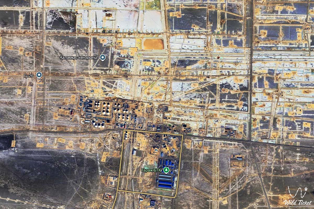
Kalamkas Oil Field
Hydrocarbon reserves and unique marine and terrestrial ecosystems –
The Kalamkas Oil Field (Kaz. Qalamqas munai ken orny) represents one of the largest and strategically vital hydrocarbon production complexes in western Kazakhstan. This vast hydrocarbon field is situated within the borders of the Mangystau district, in the northern sector of the flat Buzachi Peninsula, in immediate proximity to the coastal shoreline of the Caspian Sea.
This entire extensive semi-desert and salt-marsh territory serves as a key industrial center of the region, where the harsh climate of the northern Caspian basin meets advanced petroleum extraction technologies. For hundreds of kilometers around stretch open horizons where thousands of petroleum specialists conduct year-round subsurface development.
In the transport and logistical architecture of the Mangystau region, the development of the Kalamkas field established a robust network of motorways and technical access routes, firmly connecting the production site with the regional capital and neighboring projects. The primary overland route from Kalamkas leads south through the neighboring Karazhanbas field and onward to the city of Aktau, from where hydrocarbon flows and industrial equipment are routed toward international shipping terminals.
From the oilfield, transport arteries branch out toward the Caspian coast, to the ancient shrines and natural landmarks of the Tupkaragan Peninsula, to the historic port town of Fort-Shevchenko, and to the bay and settlement of Bautino.
The geological foundation of the field lies at comparatively shallow depths within thick terrigenous strata of the Jurassic and Cretaceous periods, formed hundreds of millions of years ago on the bed of the vanished ancient Tethys Ocean.
From Kalamkas facilities, steppe and salt-flat tracks lead researchers and overland travelers to the region's distinct natural landmarks: to the chalk cliffs of the Bozzhira tract, the Tuzbair salt flat, Mount Bokty, the Karynzharyk depression, and the boundless expanses of the Ustyurt State Nature Reserve.
The primary technological hallmark of the project is the intricate array of engineering solutions for coastal oilfield development, including advanced reservoir pressure maintenance methods and reliable protection of the fragile littoral ecosystem.
After concluding work shifts on the high-tech installations of Kalamkas, specialists frequently set off on journeys across the historical and sacred destinations of Mangystau – to the Shakpak-Ata underground mosque (UNESCO site), the rocky defile of Tamshaly, the Zhygylgan sinkhole, and the shores of Sarytas Bay.
Today, the Kalamkas field is recognized as one of the essential industrial strongholds of the Republic of Kazakhstan. Alongside the offshore giant Kashagan on the Northern Caspian shelf and the onshore supergiant Tengiz in the Atyrau region, the Karazhanbas field also contributes significantly, while Kalamkas forms the industrial backbone of western Kazakhstan.
The complex commands the attention of global energy experts, ecologists, and engineers through advanced recovery methods, high industrial safety standards, and a prominent contribution to the regional economy.
--------------------------------------------
Geography, logistics, and transit corridors –
The Kalamkas field is located in the northern sector of the Buzachi Peninsula, within the Mangystau district of the Mangystau region, in immediate proximity to the coastal waters of the Caspian Sea, approximately 270–290 kilometers north of the city of Aktau. The terrain is a level semi-desert and coastal salt-marsh plain lying within the sphere of influence of the maritime climate.
GPS geographical coordinates of the Kalamkas field:
45°21'02"N 51°54'46"E
Controlled access zone and security regulations: the Kalamkas field is a strategic operational facility subject to heightened industrial safety and occupational health requirements. Access to the field territory, residential rotation camps, and processing complexes is strictly regulated and permitted exclusively for accredited personnel, contractors, and authorized delegations holding special passes. Unrestricted access for general tourists and unauthorized vehicles is closed.
Logistical links with Mangystau and the Caspian: Kalamkas is integrated into the regional transport grid:
– Highway Aktau – Karazhanbas – Kalamkas – the primary transport artery linking the northern production fields of the Buzachi Peninsula with the regional capital and port facilities.
– Maritime and coastal logistics – proximity to the Caspian Sea enables coordinated equipment deliveries via the Port of Aktau and support bases on Tupkaragan.
Shift camp infrastructure: Kalamkas operates as an autonomous industrial complex supported by comprehensive residential and municipal engineering networks. Facilities include modern rotation dormitories, canteens, medical clinics, power plants, boiler stations, water treatment systems, and a certified helipad for emergency medical evacuation and priority transport.
Climatic conditions: northern Buzachi experiences a sharply continental, arid, and severe coastal climate. Summers are hot, characterized by high evaporation and dry winds. Winters are cold and windy, averaging -10...-15 °C in January, accompanied by gale-force Caspian winds, frequent blizzards, and ice formation across the shallow coastal waters.
--------------------------------------------
History
The history of discovery and development at the Kalamkas field reflects the success of Soviet and Kazakhstani geological exploration amidst the harsh deserts and coasts of Mangystau.
The underlying geological structure was initially identified through seismic surveys in the early 1970s during an exploration campaign on the Buzachi Peninsula. In 1976, an exploration well yielded the first commercial flows of oil and gas, confirming the discovery of a major deposit.
Developing Kalamkas required overcoming tough natural and environmental barriers: remote logistics, absence of natural freshwater sources, and aggressive saline soils demanded the creation of fully autonomous infrastructure. In the 1980s, active industrial expansion unfolded with the construction of roads, high-voltage power lines, and permanent rotation settlements.
Following Kazakhstan's independence, field development gained new momentum under national and joint operating entities, ensuring steady production, equipment modernization, and the implementation of rigorous ecological standards.
Geological phenomenon and development characteristics
Kalamkas features distinctive geological parameters that differentiate it from other hydrocarbon fields in the region.
Reservoir structure: hydrocarbons are concentrated in multi-layer sandstone-clay sequences of the Jurassic and Cretaceous periods at shallow and moderate depths. The oil and gas occur within thick reservoir zones that necessitate effective pressure-maintenance systems.
Reservoir Pressure Maintenance (RPM) systems: to maintain consistent crude output, extensive water injection is deployed across the field. Treated and prepared waters serve as the displacement agent, stabilizing reservoir energy and sustaining high extraction rates.
Coastal engineering solutions: the direct proximity of the Caspian Sea dictated specialized designs for well construction and pipeline networks across waterlogged salt flats and coastal shoals, utilizing heavy-duty anti-corrosion protection.
Detailed description of the venue
The industrial and infrastructure complex of the Kalamkas field encompasses the following key operational components:
• Central Processing Facility (CPF) – the primary technological hub for crude separation, dehydration, desalting, and initial stabilization.
• Production and injection well inventory – an extensive network of wells equipped with modern submersible electric pumps and automated telemetry systems.
• Cluster pumping stations (CPS) – engineering nodes for injecting treated water into reservoir pressure maintenance systems.
• Kalamkas rotation village – a self-contained modern residential complex providing comprehensive domestic, medical, and technical support for operating crews.
• Power and transport infrastructure – high-voltage power transmission lines, gas turbine power generation units, boiler houses, and paved access roads.
• Associated petroleum gas utilization network – environmental recovery installations converting associated gas into on-site electric power and heat.
Ecology, wildlife, and industrial camp life
The natural landscape of the northern coast of the Buzachi Peninsula is distinguished by extreme aridity and environmental fragility. Semi-desert salt flats meet the shallow waters of the Caspian, forming an ecological niche. Vegetation consists of hardy halophytes, wormwood, and saltworts, while wildlife includes desert-adapted species – goitered gazelles (dzheiran), corsac foxes, rodents, and a rich avian fauna along the coast, where migrating waterfowl congregate during transit.
Environmental policy at the Kalamkas field is founded on strict ecological safety and conservation of northern coastal ecosystems. The field has eliminated regular flaring by utilizing associated gas for power generation, and all industrial effluents undergo multi-stage filtration at modern treatment facilities before recycling into closed technological loops.
Directly beside the production sites operates an autonomous shift camp ensuring comfortable living and working standards for employees: modern dormitories, dining halls, medical units, fitness areas, and self-sufficient power supply. Rotation work in this remote northern terrain requires technical skill, physical resilience, and teamwork, while automated digital controls enhance operational safety.
Legend
A regional steppe legend concerning the Caspian Wind and the Subterranean River is told across northern Buzachi in connection with the discovery of Kalamkas.
Lore recounts that in ancient epochs, nomadic clans moving along the shifting Caspian shoreline believed that deep beneath the salt plains flowed invisible currents of the prehistoric Tethys Ocean, carrying life-giving vitality and latent heat. Desert winds swept over caravan trails, leaving white saline patterns on the clay that resembled ancient script.
Centuries later, Soviet geologists exploring northern Buzachi for petroleum named the discovered field Kalamkas, which translates poetically as "delicate dark eyebrow" – honoring the graceful curves of the sand ridges and coastal cliffs.
Ever since, local belief across Mangystau maintains that Kalamkas stands as an emblem of harmony between the untamed nature of the Caspian and the constructive labor of humankind, turning remote salt flats into a wellspring of regional prosperity.
Conclusion
The Kalamkas field is an outstanding example of engineering skill and dedicated petroleum teamwork, overcoming the challenging conditions of the Buzachi Peninsula. Exploring the history and technologies of Kalamkas provides insight into the industrial and natural depth of the Mangystau region, where deep-earth geology pairs with the northern shores of the Caspian Sea.
Interesting sights nearby:
• Buzachi Peninsula;
• Karazhanbas Oil Field;
• Port of Aktau;
• City of Aktau;
• Town of Fort-Shevchenko;
• Village of Bautino;
• Cape Tyub-Karagan;
• Zhygylgan Sinkhole;
• Tamshaly Canyon;
• Shakpaktysay Canyon;
• Shakpak-Ata Underground Mosque;
• Kapamsay Canyon;
• Tauchik Village;
• Otpan-Tau Historical and Cultural Complex.
Sacred sights and pilgrimage destinations:
• Sultan-Epe Mosque;
• Kenty-Baba Necropolis;
• Khanga-Baba Necropolis;
• Yerzhan Khazret Mausoleum;
• Karaman-Ata Mosque;
• Sisem-Ata Necropolis;
• Shopan-Ata Mosque;
• Beket-Ata Mosque in Oglandy;
• Koshkar-Ata Necropolis.
Photogallery: