Chain of residual mountains with spires and natural colonnades in the heart of the Valley of Castles –
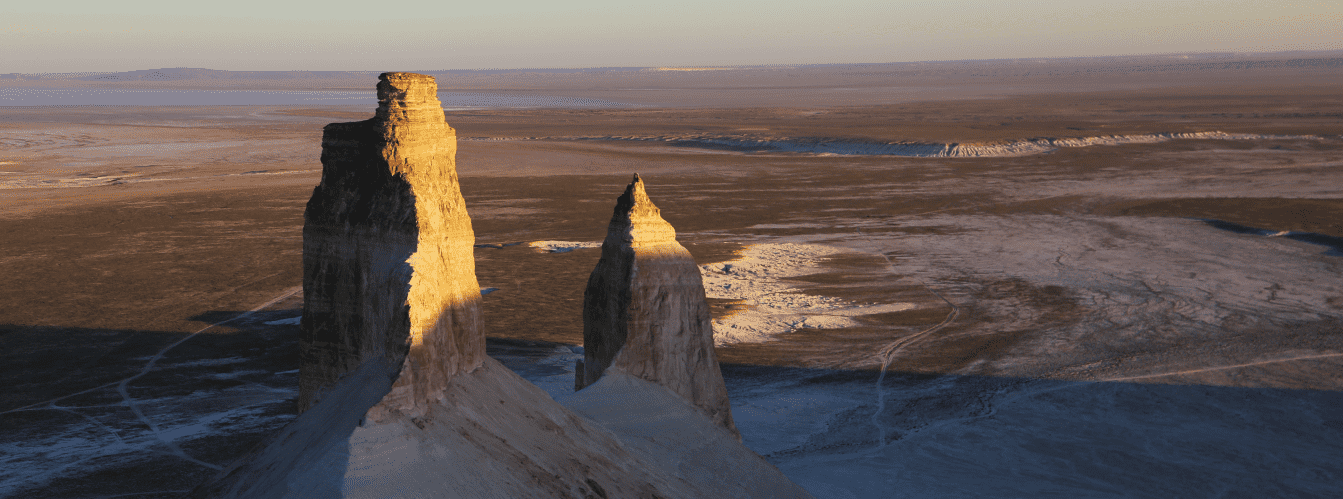
The Shomanai mountain massif (Shomanai mountains) is an eleven-kilometer chain of table-and-butte uplands and natural bastions in the central part of the Mangyshlak upland within the Mangystau district. The massif owes its fairytale-like silhouette of towers, colonnades, and crenellated walls to the selective weathering of the layered strata of the Mesozoic sedimentary cover.
The upper horizons are formed of durable silicified sandstones and limestone slabs that protect the softer underlying clays, gypsums, and marls from destruction. Over millennia, desert winds, rain torrents, and diurnal temperature fluctuations wore down the pliable rocks, transforming the mountain ridge into a grand complex of natural castles connected by stepped scree saddles.
The massif is located in an intermontane depression, occupying a strategic position among the key orographic systems of the region. To the northeast, its slopes border the Northern Aktau ridge, just 3 km to the southeast begins the Eastern Karatau ridge, and 10 km to the southwest rises Western Karatau. The Ktairakty massif lies 5 km to the west, and 4 km to the northwest sits the Akmyshtau massif. This entire system of residual buttes is traditionally known among local residents and travelers as the Airakty-Shomanai tract (Valley of Castles).
The total length of the massif from southeast to northwest is 11 km, with a width in the central part of up to 6 km. Along the western foot runs the Aktau – Beineu railway line. The valley serves as a popular point on loop tours of Central Mangystau: from here, routes lead to the sacred mount Sherkala, the Kogez tract, Samal gorge, the Akmysh spring, and the Karaman-ata necropolis.
The highest elevation of the massif is mount Shomanai in the southern part, standing 368 meters above sea level, with mount Zhapyrakty located slightly to the south at an altitude of 363.8 meters. A wild, winding path on one of the summits leads to a narrow observation platform that opens a breathtaking panoramic view of the distant snow-white ridges of Aktau.
On its eastern side, the Shomanai mountain ridge adjoins a unique site of spherical concretion outcrops: here one can find flawless stone spheroids resembling bowling balls. During a moist spring, the desert valley at the foot of the mountains transforms, blanketed by delicate carpets of blooming Sogdian tulips, while cautious Ustyurt mouflons can be spotted along the rocky ledges.
--------------------------------------------
How to get there and visit –
The Shomanai mountain massif is located in the central part of the Mangystau district of the Mangistau region in Kazakhstan. The distance from the city of Aktau is around 175–185 km, roughly 20–25 km north of the district center of the village of Shetpe, 4 km southeast of the Akmyshtau massif, and 5 km east of the Ktairakty massif.
GPS geographic coordinates of the central part of the Shomanai massif:
44°14'08"N 52°11'44"E
The route from the city of Aktau leads northeast along a paved national highway through the village of Zhetybai to the village of Shetpe (about 160 km of high-quality asphalt). From Shetpe, exit north along the paved Shetpe – Shaiyr highway. Before reaching Shaiyr (near the railway crossing and the Akmysh tract), turn right onto a well-beaten steppe dirt road heading east. The country track crosses dry riverbeds, skirts the Akmyshtau buttes, and reaches the western flank of the Shomanai massif. To reach the eastern field of concretions, you must skirt the massif along the southern or northern arc along gravelly steppe trails. Travel time from Aktau takes about 2.5 hours.
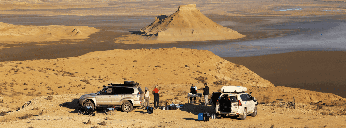
Access roads and vehicle requirements: accessing the western slope of the ridge in the dry season is possible in crossovers. However, completing a full loop around the 11-kilometer massif, negotiating ravines at the base, and driving along the eastern gravelly apron to the concretions requires a four-wheel-drive 4x4 SUV with ground clearance of at least 220 mm. On the eastern side, the track is often lost among stony screes and crosses washouts with steep walls. The vehicle must be fitted with All-Terrain (AT) tires with reinforced sidewalls, a spare wheel, a tire compressor, a tow strap, and a tool kit.
ATTENTION: in early spring and after rainstorms, driving along the base of the ridge becomes extremely difficult. Clay deposits from Albian strata turn into a slick, soapy mud that clogs tire treads. Driving is permitted only along dry, stony ridges.
Hiking excursions and safety: exploring the ravines and the base of the massif is done on foot. Sturdy trekking shoes with rigid soles are mandatory when crossing gravelly slopes and ascending ledges: sharp flint fragments and fine marl slip easily underfoot. In deep erosional cirques, the rocks are subject to constant flaking: keep a safe distance from vertical cornices to avoid falling stones. Steppe vipers, Pallas's colubers, scorpions, and camel spiders inhabit wormwood thickets and hide beneath limestone slabs.
Environmental safety rules: the Shomanai mountain massif is a unique natural complex of Mangyshlak.
Within the massif, it is STRICTLY MANDATORY TO:
– carry out all household trash (plastic, tin cans, glass, wipes) back to the village of Shetpe;
– drive motor vehicles strictly along existing country roads, without creating new ruts across untouched land;
– strictly refrain from splitting, damaging, or loading spherical concretions into vehicles;
– avoid lighting open fires using dry saxaul and shrubs;
– refrain from picking or digging up Sogdian tulip bulbs on the surrounding plains;
– avoid approaching mouflon grazing grounds, maintaining complete quiet.
Infrastructure: within the boundaries of the Shomanai mountain massif, all infrastructure is entirely absent (there are no campsites, sources of fresh drinking water, electricity, or shops). Expeditions are carried out in full autonomy. The drinking water supply must be at least 4–5 liters per person per day. Base camps are pitched at the base of the western or eastern slopes on the leeward side. All essential services (gas stations, service stations, tire repair, shops, pharmacies) are located in the district center of Shetpe (20–25 km). Mobile phone reception from major Kazakhstani operators works reliably along the western edge of the massif near the railway, but is blocked by cliffs in the eastern ravines and cirques.
The best time to visit is spring (from the second half of April through late May) and early autumn (September – first half of October). In May, air temperatures stay within a pleasant +18...+25 °C, and the surrounding plains are green. Autumn brings gentle warmth and a lack of wind. In July and August, travel is complicated by exhausting heat (exceeding +40 °C in the shade): dark sandstones and limestones heat up intensely in the sun, creating a severe microclimate inside intermontane hollows.
--------------------------------------------
History
The history of the Shomanai mountain massif links the formation of sedimentary strata of the Turan lowland, memories of nomadic caravan passages, and stages of industrial development across the Mangyshlak upland.
During the Late Mesozoic and Paleogene epochs, coastal-marine sediments of epicontinental basins accumulated across this territory. In subsequent phases of tectonic activity, the uplifted block of the limestone-sandstone plateau underwent intense erosional dissection. Seasonal flash floods of ancient river systems carved deep through-valleys into the rocks, severing the Shomanai massif from the neighboring Ktairakty and Akmyshtau buttes.
In the Middle Ages, the intermontane corridor at the base of Shomanai served as a natural transport route. Merchant caravans traveling from the port anchorages of the Caspian through Mangyshlak into the interior of Eurasia used the passes between the Aktau and Karatau ridges for shelter from the gale-force winds of the open steppe. For the clans of the Aday tribal confederation, the massif was an important part of the seasonal nomadic system: livestock found shelter from blizzards in mountain ravines, and groundwater lenses at the base provided water in well shafts (kuduks).
A new chapter in the history of the territory began in the second half of the 20th century in connection with rapid industrial development across Mangyshlak. The Aktau – Beineu railway line was constructed along the western foot of the Shomanai ridge, becoming a transport artery for carrying oil and mineral resources and delivering construction cargo. The rocky cliffs of the massif served as visual landmarks for Soviet geodesists and geologists mapping the subsurface of Central Mangystau.
In the 21st century, the Shomanai massif became a destination for road travelers and researchers of arid geomorphology. The presence of rare mineral formations, pristine isolation from mass tourist traffic, and the contrast of desert landscapes have secured the massif a permanent spot on regional expedition itineraries.
Information
In structural and geological terms, the Shomanai mountain massif is an erosional table-and-butte ridge composed of sedimentary strata of the Albian, Cenomanian, and Turonian stages of the Cretaceous period.
Morphometric characteristics of the massif:
– total length of the ridge: 11 km (aligned southeast to northwest);
– width in the central part: up to 6 km;
– highest point of the southern sector: 368 m above sea level;
– elevation of the southern peak of Zhapyrakty: 363.8 m above sea level;
– hypsometric level of the adjoining steppe plain: 150–180 m above sea level;
– relative elevation of the crests above the basin floor: from 120 to 200 m.
The stratigraphic cross-section reveals a distinct threefold structure:
1. The lower base horizon, measuring up to 80 m in thickness, consists of a sequence of hydromica-bearing gray and greenish marls and carbonate clays of the Albian stage.
2. The middle tier is composed of a sequence of quartz-glauconite stratified sandstones of the Cenomanian up to 50 m thick, with interbeds of ferruginous aggregates and iron-rich siltstones.
3. The upper protective layer, varying from 5 to 15 m in thickness, is formed of durable silicified platy limestones of the Turonian stage, which preserve the massif from complete destruction.
The mineralogical highlight of the eastern apron of the massif is represented by fields of spheroidal carbonate-sandstone concretions. These mineral bodies developed during early sediment diagenesis through the diffusive concentration of calcium carbonate around organic nuclei within water-saturated sand beds. The cement density within the concretions is significantly higher than that of the host rock, allowing erosion to expose the spheres at the surface without disrupting their geometric form.
The climate of the area is sharply continental and arid. The average January temperature is -5...-8 °C, and July averages +28...+32 °C, with daytime highs up to +42 °C. Annual precipitation does not exceed 140–160 mm, against an average annual evaporation exceeding 1,000 mm.
Detailed site description
The natural geomorphological complex of the Shomanai mountain massif comprises the following structural sectors and landscape elements:
• Main eleven-kilometer Shomanai ridge – an extended folded-erosional ridge with a jagged crest line, composed of tiers of limestones and sandstones and oriented southeast to northwest;
• Eastern apron of spherical concretions – an inclined belt of piedmont scree at the eastern foot of the massif, strewn with dozens of dense stone spheres of regular shape ranging from 0.3 to 1.5 meters in diameter;
• Western barrier scarp – a stepped wall of the massif facing the Aktau – Beineu railway line, composed of steep cliffs of dark yellow sandstones and white marls;
• Intermontane erosional cirques – deep, semicircular wind-scoured hollows within the body of the massif with sheer walls, featuring specific wind acoustics and protection from external storms;
• Northern connecting saddle – a gentle, stony watershed connecting the Shomanai massif with the slopes of the Northern Aktau ridge;
• Southern butte sector – the most elevated part of the ridge with steep screes and flat table summits, terminating the massif before the Karatau depression;
• Piedmont clay-gravel aprons – broad, level areas at the base of the mountains with compact ground, serving as a route for driving around the massif in 4x4 vehicles.
Flora and fauna
Plant life across the Shomanai massif displays a pronounced semi-desert character and is adapted to carbonate-gravel soils. Stony slopes are dominated by communities of Anabasis salsa (biyurgun), white wormwood, Lerche's wormwood, boyalych (tree-like saltwort), and gray winterfat. In deep erosional ravines where moisture collects, twisted shrubs of black saxaul, tamarisk, and rare Atraphaxis take root. In spring (late April – May), the plains at the foot are carpeted with populations of Sogdian tulips, wild onions, poppies, and yellow star-of-Bethlehem, which wither away by early summer.
Wildlife is distributed across the altitudinal tiers of the ridge. A population of the red-listed Ustyurt mountain sheep (mouflon) stays permanently in rocky ravines and on upper ledges. On the flat aprons at the base, burrows of gerbils (great and red-tailed), jerboas, and tolai hares are common. Predatory mammals hunting here include corsac foxes, steppe polecats, badgers, and marbled polecats.
Birdlife is represented by raptors utilizing sheer limestone ledges for nesting: golden eagles, long-legged buzzards, steppe eagles, saker falcons, kestrels, and eagle owls. Desert larks, isabelline wheatears, black-bellied sandgrouse, and saxaul jays inhabit the foothills.
Common reptiles on sun-warmed sandstone slabs include rapid fringe-toed lizards, toad-headed agamas, steppe agamas, and gray geckos. Venomous snakes and arachnids shelter in rock crevices: Pallas's colubers, steppe vipers, black widows, camel spiders, and scorpions.
Legend
An ancient Kazakh legend of the Khan's Cannonballs and the Unassailable Wall is told about the Shomanai massif.
The story goes that when ancient caravan routes crossed these valleys, the ruler of these lands resolved to raise an insurmountable barrier against deceitful steppe invaders. He turned to master stone carvers to chisel thousands of regular round stone spheres out of hard rock to guard the entrances into the gorges.
When the enemy army reached the borders of the valley, the khan's warriors took up defensive positions on the mountain summits. However, the enemy's forces vastly outnumbered the defenders. The khan then raised his hands to the sky and prayed to the mountain spirits to save his homeland at any cost.
Thunder crashed in that very instant: the earth shook, and the extended chain of hills merged into a single monolithic stone wall—the Shomanai massif, cutting off the enemy's path. Thousands of carved stone cannonballs rolled down the eastern slope to the foot of the mountains, freezing into rock as spherical concretions. Terrified by the wrath of the spirits, the invaders fled the valley, and the stone wall of Shomanai remained an enduring shield guarding the peace of the Mangystau land.
Conclusion
The Shomanai mountain massif is an extensive geomorphological monument of Central Mangystau, where the rugged scale of Cretaceous strata meets diverse desert landforms. A loop route around the eleven-kilometer ridge, clusters of spherical concretions in the eastern sector, and contrasting panoramas of the Northern Aktau and Karatau ridges make the massif an important point for exploratory journeys across the Mangyshlak peninsula.
Interesting attractions nearby:
• Eastern field of spherical concretions of the Shomanai massif;
• Aktau mountains;
• Karatau mountains;
• Solitary mount Sherkala;
• Akmysh tract and oasis;
• Samal gorge;
• Kogez ethno-village;
• Torysh valley of round stones;
• Village of Shetpe;
• City of Aktau;
• Ktairakty residual mountain massif;
• Akmyshtau massif;
• Aktau – Beineu railway line.
Photogallery: