Unique military-historical landscape complex -
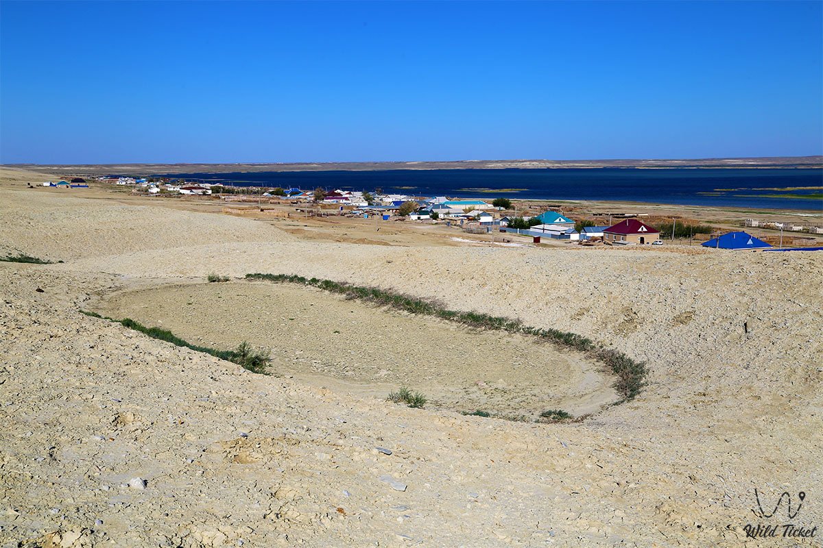
Fort Raim, also known as the Aral Fortification, is an original memorial and natural ensemble located at an altitude of 94.9 meters above sea level in the Aral district of the Kyzylorda region. This grandiose historical site is situated on a gentle elevation with steep banks, occupying the southwestern part of a natural peninsula between the fresh lakes Raimkol and Zhalanashkol, 2.6 kilometers northeast of the right bank of the Syr Darya River.
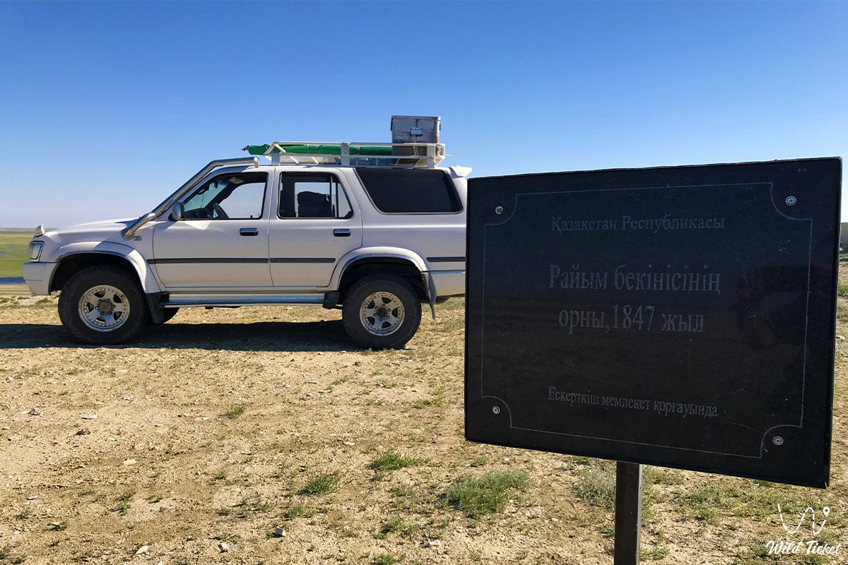
The construction of this strategic space, designed and built by the outstanding military engineer K. I. Gern in 1847, became an important stage in the history of the development of the Aral region. The first Russian military fortification in the region appeared as a response to the uprising led by Kenesary Kasymov to prevent nomadic incursions and protect trade caravans. It is best to travel to the fort from the city of Aralsk.
The historical hill is located in the western part of the village of Raim of the same name (the administrative center of the Zhetes rural district) with a population of about 300 people, 20-22 kilometers southwest of the village and railway station of Kamystybas and 41-46 kilometers northwest of the city of Kazalinsk.
Today, this fort is considered one of the most popular places for historical and educational tourism, local history expeditions, and photo tours to the Aral Sea and the Small Aral. The surrounding coastal territory, dotted with archaeological artifacts of the Paleolithic era (arrowheads, stone knives, and scrapers), attracts travelers from all over the world, creating a single landscape axis with the first scientific stations of the region and sharply contrasting with the steppe horizons of the right bank of the Syr Darya.
This link will take you to the section of tours to the Aral Sea and the Small Aral Sea.
---------------------------------------------
How to get there and visit -
Fort Raim is located on the western outskirts of Raim village, 84 kilometers from Kazalinsk city, 25 kilometers from the Kamystybas railway station, on the peninsula between lakes Raimkol and Zhalanashkol, Aral district, Kyzylorda region, Republic of Kazakhstan.
GPS coordinates: 46°04'18"N 61°43'42"E
The transport logistics of this wild region completely exclude urban public transport. No regular buses or city taxi services operate here. You can reach the historical settlement by car from the Kamystybas railway station in just half an hour, covering 25 kilometers, or from the city of Kazalinsk – the journey will take about an hour and a half (84 kilometers along the roads of the district).
Only a prepared four-wheel-drive SUV is suitable for the trip, as difficult steppe, dirt, and sand roads lead to the hill itself. Drivers must carry an additional supply of fuel, drinking water, navigators, and satellite communication devices.
Opening hours: The territory of the monument is open for visits around the clock and all year round. Access to the adjacent territory is completely free; there are no ticket offices, admission fees, or paid checkpoints here.
It is recommended to plan a trip to this region for the spring or early autumn period to avoid extreme summer heat and sandstorms. All tent camps and parking sites are organized by tourists independently under expedition conditions, adhering to the rules of respect for the historical layers and archaeological remains of the ancient settlement.
---------------------------------------------
History
The history of this legendary military settlement began in 1847 with the arrival of the first residents – 26 families of Orenburg Cossacks, who settled in the new barracks. The structure immediately became a key base for the birth of the Aral Flotilla: in 1849, the two-gun schooner "Konstantin", built in Orenburg, was delivered in disassembled form to the Syr Darya in the area of the fort with a crew of 27 people. It was this ship that served as the basis for a large-scale marine expedition led by Lieutenant Alexei Butakov in 1848–1849, during which great geographical discoveries were made – a whole group of large islands was discovered, of which even the coastal residents had no idea.
A special place in the history of Raim is occupied by the great Ukrainian poet and artist Taras Shevchenko, who served here as a private and visited the fort three times (in the summer of 1848 he lived in the kibitka of A. Maksheyev, in the winter and spring of 1849, and in the autumn of the same year). He captured the outlines of the fortress in a series of unique watercolors and drawings "Fortification Raim", and also described the mouth of the Syr Darya in detail in the novella "The Twins", letters, and "Diary".
In 1851–1853, the main part of the fort's population was relocated to Kazalinsk, but an important river port operated here for several more years. The first iron steamers "Perovsky" and "Obruchev" were delivered here from Sweden in disassembled form.
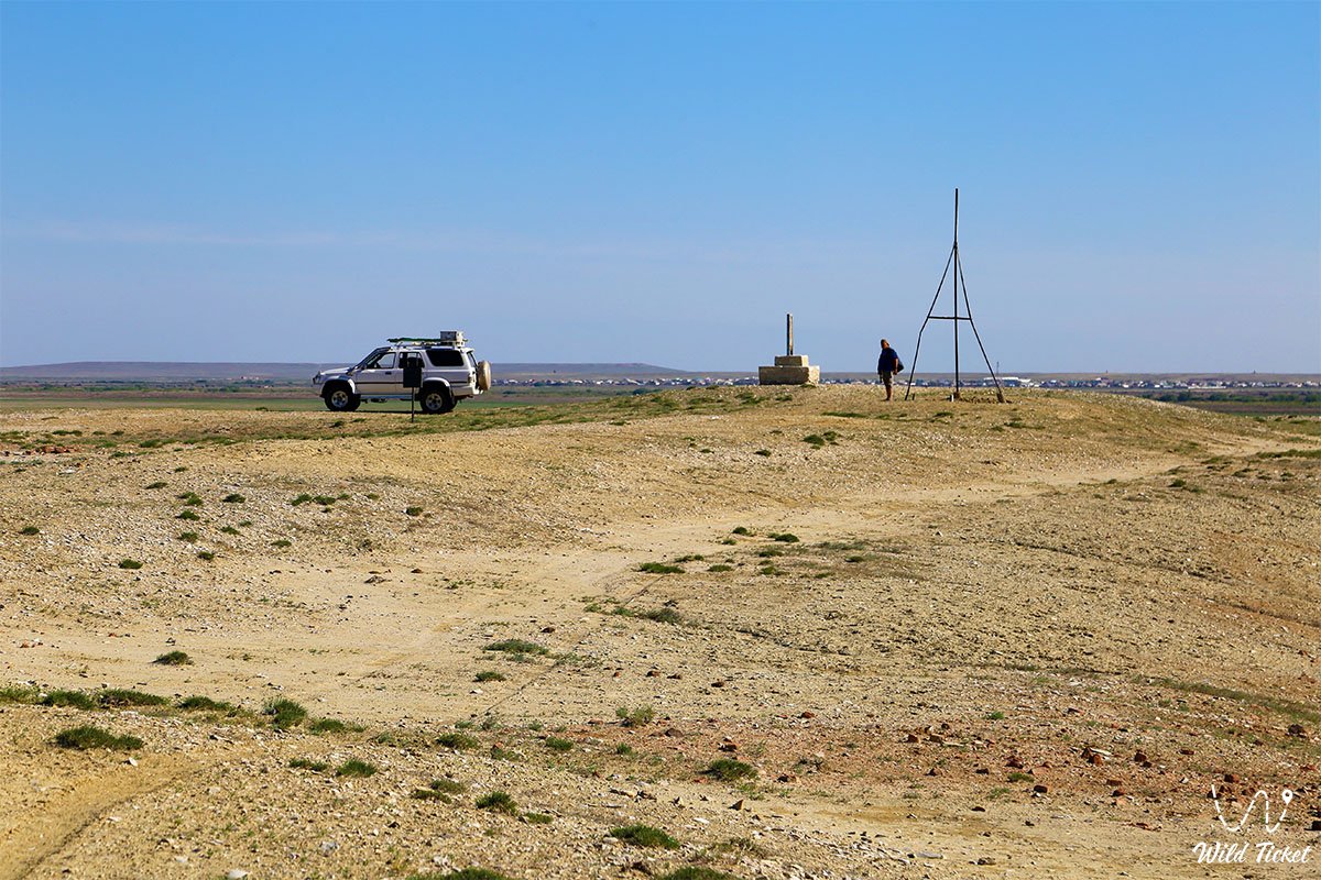
In 1854, due to changes in border lines, Fort Raim was officially abolished and abandoned. Today, the buildings of the fortress are not visible from the top of the hill, but from a bird's-eye view, the geometric outlines of the former ramparts and ditches can be clearly guessed.
Information
Fort Raim is organized as a complex multifunctional historical space divided into three distinct thematic zones. Excellent conditions have been created here for conducting archaeological research, field local history lectures, and organizing tent camps for participants of expedition tours. For fans of educational recreation, commemorative signs and detailed information boards telling about shipping, Butakov's campaigns, the life of the garrison, and the work of Taras Shevchenko have been installed on the top of the hill, where Soviet cartographers actively worked in the 1930s.
Local historians and ecologists pay special attention to preserving the pristine landscape: the adjacent sections of fresh water bodies are regularly cleared of garbage, and the state of the ancient cultural layers of the Paleolithic is monitored. For the convenience of travelers' navigation, rare signs are installed on field roads. Tour organizers recommend moving around the territory of the settlement on foot, strictly maintaining silence and treating with care the fragments of treated ancient stones that still lie literally underfoot.
Detailed description of the venue
The well-thought-out infrastructure of the historical complex includes the following original locations and geographical features:
• Wrapped hill Raim – the top point of the defensive relief at an altitude of about 40 meters above the water edge level, from where a circular panoramic view of the lakes and the silvery ribbon of the Syr Darya opens up.
• Remains of the fortress outline – washed-out earth embankments, ramparts, and long lines of ditches designed by engineer Gern to protect against Khivan raids.
• Site of the historical shipyard – the coastal sector where the schooner "Konstantin" and Swedish iron steamers were assembled, serving as the beginning of the Aral Shipping Company.
• Garrison sector – a flat area on the cape, where a long barrack covered with reeds, a powder magazine, and a wooden Christian church erected in the winter of 1848 were previously located.
• Paleolithic site – the upper sector of the plateau, where researchers still find flint knives and arrowheads processed by the hands of primitive man.
• Field expedition sector – an area at the foot of the hill near the modern village of Raim, convenient for parking SUVs.
Architecture
The architectural solution of the fort was based on the classical principles of rectangular field fortification of the Russian Empire of the mid-19th century. The strict layout of the defensive walls harmonized smoothly with the natural steep ledges of the peninsula, creating an inaccessible frontier. The highlight of this military engineering was the juxtaposition on one site of objects of different cultures: a Muslim stone tombstone-crescent and a Christian garrison church, which was reflected in Shevchenko's drawings.
During construction, local materials were used – raw brick, reeds for the roofs of barracks, turf and wild coastal stone for the foundations of port facilities. The entire ensemble fit organically into the harsh natural landscape, preserving the authentic spirit of a bygone era.
Legend
An ancient legend about the origin of the fort's name, recorded by Captain A. Maksheyev, lives among local residents and guides. According to legend, Raim was a famous and brave batyr, a courageous caravan leader who protected his native lands from Khivan raids and knew all the roads of the Aral region.
In one of the fierce battles, he was mortally wounded, and his war horse brought him to this high hill. The residents buried the hero on the top of the cape, building a sacred stone mausoleum (abu) in the shape of a crescent. According to legend, his son Almambet became a close friend of Taras Shevchenko and a guide for Butakov's expedition.
Although in 1852 one of the commanders of the fortress ordered the destruction of the mazar, old-timers believe that the spirit of batyr Raim still guards this hill and helps travelers predict the weather in the steppe.
Conclusion
Fort Raim is a magnificent historical bridge connecting the dramatic events of military campaigns of the century before last with the modern scientific and tourist life of the region. A visit to this landscape monument allows guests of the Kyzylorda region to touch the origins of the scientific development of the Aral Sea. The fort remains the main reference point for historical, military, and local history tourism in the Aral district. Expedition routes definitely include this point in their programs, allowing everyone to see firsthand the place where the great era of geographical discoveries began.
Interesting sights nearby:
• Zhankent ancient settlement;
• Karateren village;
• Ayteke Bi village;
• Barsakelmes Island;
• Barsakelmes Nature Reserve;
• Kokaral Dam;
• Tolybay Batyr Mausoleum.
Photogallery: