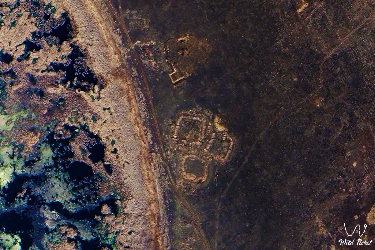
The medieval city of Bozok, located within the city limits of Astana, is a unique archaeological and cultural site in the very heart of the Eurasian steppes. The settlement, which has a rich centuries-old history, impresses with its unique layout: its defensive system and sacral zones attract the attention of every lover of antiquity at the crossroads of eras. The monument is located on the eastern elevated bank of Lake Buzykty in the floodplain valley of the left bank of the Ishim River.
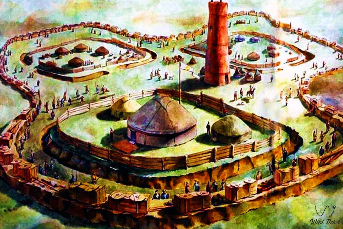
The settlement, which has a rich history, impresses with its layout and majesty: its defensive system, consisting of three square sites-quarters in the form of a three-petaled flower, and sacral zones attract the attention of every traveler and researcher at the crossroads of eras.
The choice of the eastern elevated bank of the reservoir for the construction of the headquarters was not accidental: during periods of spring floods, the entire space between the Nura and Ishim rivers was flooded, and only this remnant always remained dry, performing the role of a natural geographical landmark and obstacle.
Originally recorded by military engineer Ivan Shangin in 1816, the ruins remained hidden in the middle of swamps for a long time, which saved them from destruction by heavy machinery during the years of development of the virgin lands.
---------------------------------------------
The Bozok Settlement is located a few kilometers from Astana city, almost within the city limits near Lake Urker, next to the village of Karaotkel, Akmola region, Republic of Kazakhstan.
GPS coordinates:
Bozok Gate - 51°09'04"N 71°15'14"E;
Bozok Fortress - 51°08'41"N 71°16'15"E
Bozok Museum - 51°08'12"N 71°16'03"E
Transport accessibility of the site has its own characteristics, as it is located in a swampy floodplain zone 5 kilometers southwest of the historical Karaotkel ford.
The monument is located in a place where the winding Nura River comes closest to the Ishim, and the entire interfluve is covered with a network of small rivers and lake depressions.
It is impossible to reach the closest point to the monument by public transport directly, however, travelers can use regular suburban buses going towards the Nura district from the side of the Urker and Karaotkel villages to reduce the distance to the excavation sector as much as possible.
To get to the settlement, it is best to use a taxi service through a special mobile application.
The opening hours of most open zones and alleys of the complex are 24/7, without days off and breaks. It is best to visit the site during the daytime.
Visiting pedestrian routes and viewing the external earthen ramparts is completely free for all residents and guests of the region.
Museums, interactive ethno-sites and observation towers operate according to individual schedules.
---------------------------------------------
History
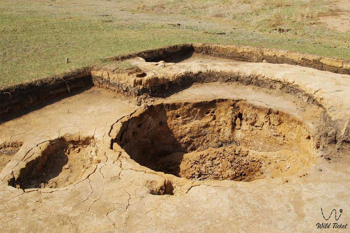
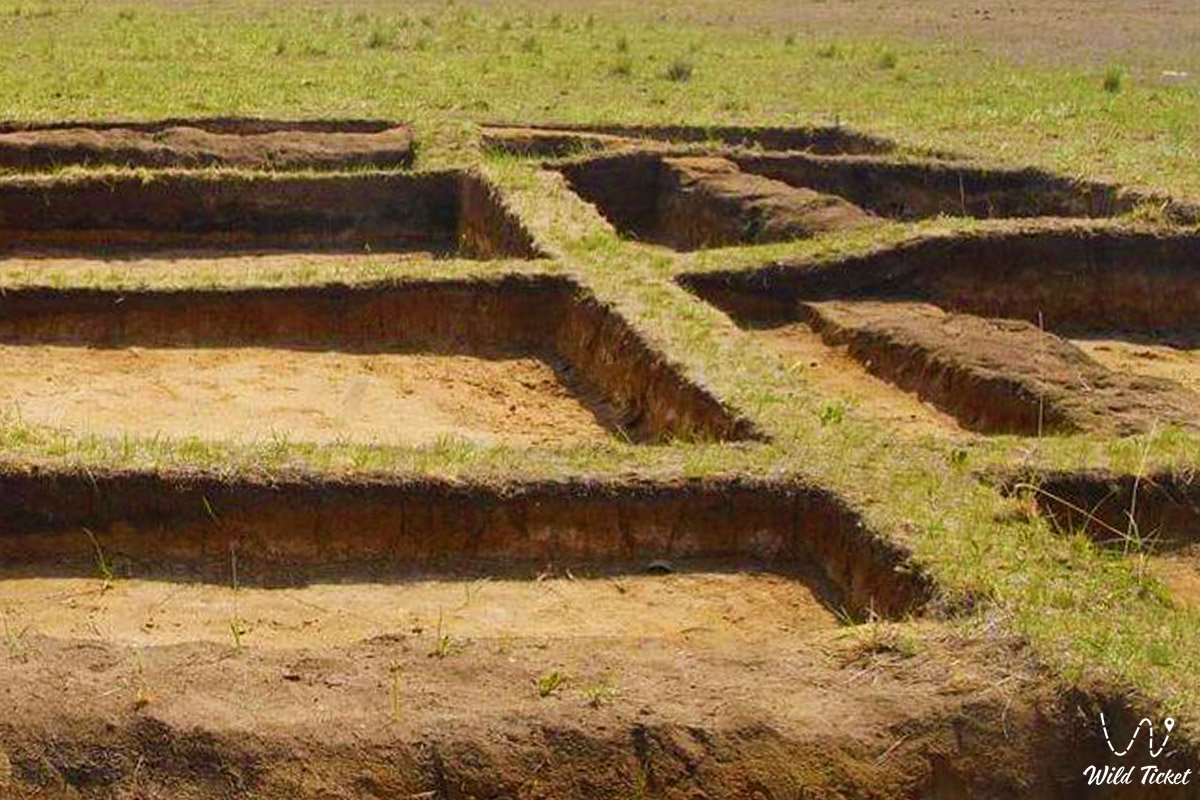
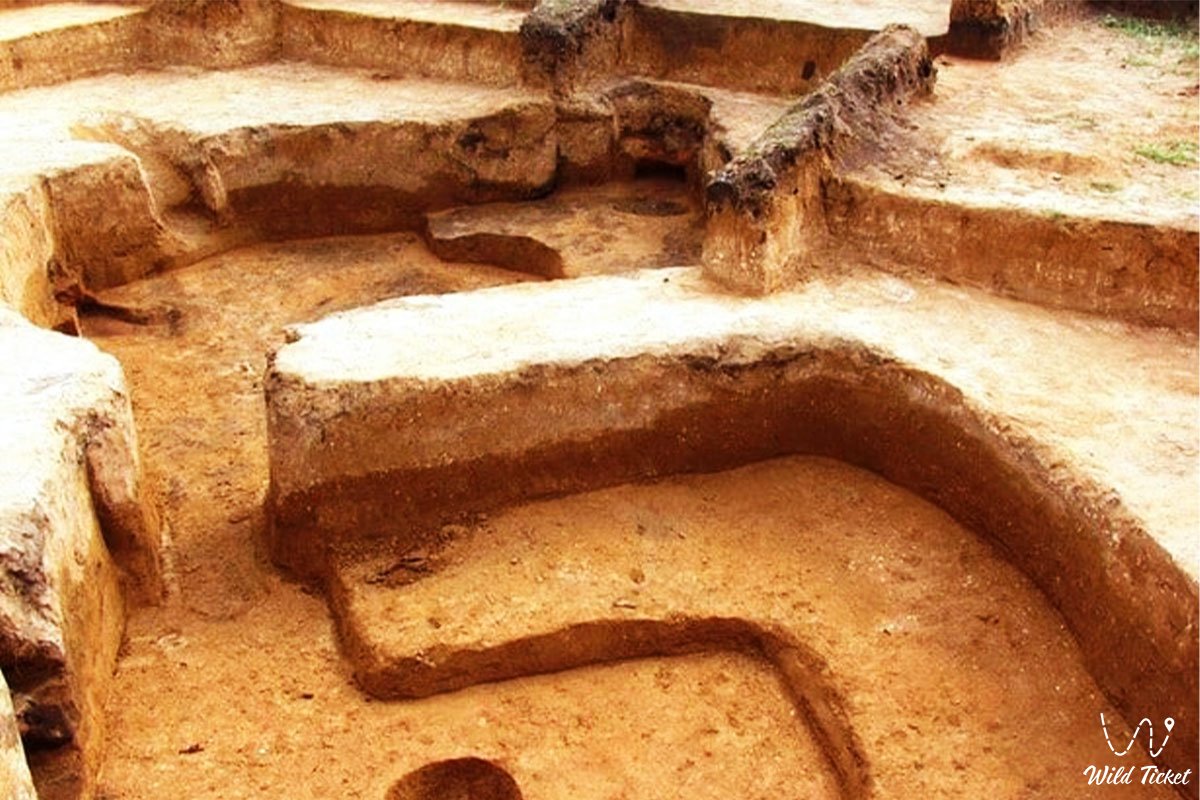
The history of the creation of the medieval Bozok settlement is inextricably linked with the development and change in the status of the entire steppe interfluve. In the early Middle Ages, starting from the 7th century, this territory was populated by ancient Turks migrating from Mongolia towards the Danube. They laid the foundation of the fortified center in the form of a three-petaled composition of quarters measuring 35x35 meters, surrounded by internal ditches up to 5 meters wide.
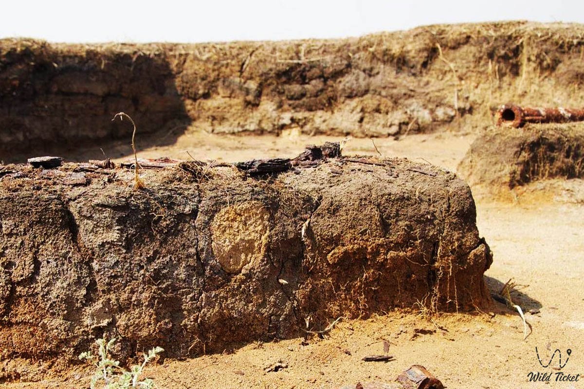
Originally recorded by military engineer Ivan Shangin in 1816, the ruins remained hidden in the middle of swamps for a long time, which saved them from destruction by heavy machinery during the years of development of the virgin lands. In Soviet times, when the surrounding lands were actively developed as an agricultural center of the virgin lands, this site actually remained untouched due to the swampy landscape, although the first virgin land developers partially dismantled the ruins of ancient mausoleums for bricks.
A new era for the monument began in 1998–1999, when the Ishim Archaeological Expedition under the leadership of the legendary Academician Kemal Akishev rediscovered the settlement, initially giving it the working name Akzhol, but later, according to written sources of Turkic-Oghuz history, it was possible to establish its authentic medieval toponym – Bozok.
The past names and eras of the city's existence reflected major historical milestones in the life of four great state formations: the Turkic Khaganate, the Kipchak Khanate, the Golden Horde, and the Kazakh Khanate. Almost the entire defensive part was built according to the strict canons of medieval fortification – the width of the walls at the base reached 8 meters, and the clay for raw bricks and pakhsa blocks was extracted directly when digging the ditches.
In the 10th–12th centuries, the settlement functioned as a military headquarters and summer residence of the leader of the Kipchak tribes (khagan) to control the caravans of the Great Silk Road.
When the site gained the status of a state museum-reserve of republican significance, large-scale design began according to the master plan for recreation of the ancient architecture of the steppe nomadic civilization. During the same period, scientists studied in detail the central sacral sector, where cult complexes, one minaret and kilns for firing burnt bricks were discovered.
Protective canopy structures over the excavations were recreated taking into account the preservation of the fragile clay layer, and on the southern outskirts of the complex, the remains of Kazakh winter quarters (kystau) of the 18th–19th centuries were recorded, showing the continuity of spiritual and everyday traditions of the region.
Information
Bozok today is a unique multifunctional space combining the features of a contact archaeological park, a scientific and educational center and a developing tourist hub. Over the past decades, the appearance of the main excursion trails changed regularly in order to create comfortable conditions for pedestrians and researchers.
In the evenings, soft decorative illumination lights up on walking routes and near monumental entrance portals. Moving along the contours of these extended earthen ramparts up to one meter high, pedestrians and researchers can reach the central sanctuary, see panoramas of ancient kurgans, visit the craft sector, study open archaeological excavations and enter the medieval necropolis, which are key public and cultural hubs of this monument.
The entire territory of the settlement represents a classic example of an archaeological palimpsest, where different cultures alternately rewrote the landscape. The central sector is considered the sacral heart of the monument. A huge number of cult sites, yurt-shaped rounded sanctuaries and memorial structures are concentrated here. Strolling here, guests often visit interactive zones or study exhibits, because life here does not stop for a minute: it is a favorite place for seminars, historical reconstructions and international conferences.
The western and southern sectors retain a calmer memorial character. There are fewer excursion groups here, Muslim necropolises, mausoleums made of burnt brick and ground burials of various eras predominate around. In this part of the settlement, the rhythm of the walk slows down a bit, objects remind of bygone centuries, and people are in less of a hurry, immersing themselves in the atmosphere of the ancient nomadic civilization. It naturally neighbors the recreational spaces of well-kept squares located at the end of excursion corridors, where every visitor can relax during the walk.
The safety of the monument from destruction and illegal excavators is provided by a 24-hour security service and video surveillance systems along the entire perimeter of the fence with a length of 8.7 km. The complex is fully adapted to the needs of people with limited mobility, equipped with convenient crossings and warm waiting pavilions, from where it is easy to walk to the craft workshops or head to the main observation tower, which is the central observation platform.
Detailed description of the site
The infrastructural and cultural content of the settlement includes many iconic sites distributed by thematic sectors:
• Historical and archaeological sector – includes halls of stationary excavations, ancient Turkic dwellings of a rounded-oval shape of the early Middle Ages, rectangular multi-room semi-dugouts of the Golden Horde, as well as research funds storing thousands of rare artifacts.
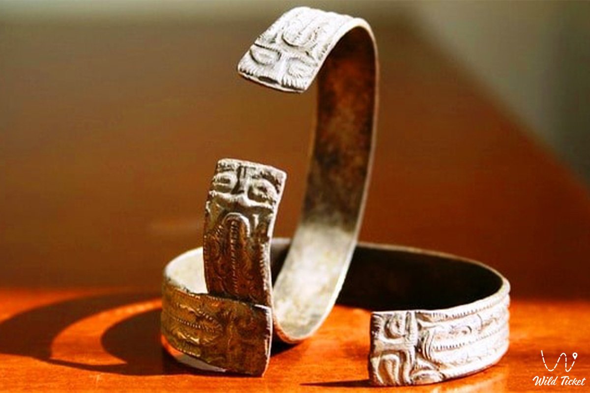
• Sacral-memorial complex – a majestic cult site, 72 medieval graves, remains of five monumental mausoleums made of burnt and raw brick, as well as memorial steles, Mongol burials and a necropolis of the Kipchak nobility. Of particular importance is the accidental discovery of the burial of the woman warrior "Inzhu" of the 13th–14th centuries in a birch bark headdress bokka, buried with a spear, a dagger and a silver bowl.
• Walking and ethnographic hub – the famous landscape promenade near the bank of Lake Buzykty, reconstructed defensive ramparts and an authentic ethno-aul. These are places of attraction for creative youth, street musicians and artists, decorated with original art installations. The composition of the complex in the form of reconstructed residential dugouts of the late 13th – middle of the 14th century with U-shaped sufas and hearths occupies a central place in the cultural space.
• Educational and interactive sites – the Palace of Young Archaeologists, sites of museum pedagogy, an open theater of nomadic culture and demonstration zones that are firmly associated by locals with the main cultural events.
• Craft-technological contour – recreated ancient production sites. Here, within walking distance from each other, medieval metallurgical and pottery complexes, a Kervansaray, as well as masters' shops offering hand-molded products operate. Nearby are also located the remains of medieval smithies, brick kilns and workshops of ancient craftsmen, which perfectly complement the historical ensemble of the eastern bank.
Architecture
The architectural appearance of the Bozok settlement clearly demonstrates the continuity of construction eras of the steppe zone. Here, ancient Turkic defensive ditches up to 5 meters wide neighbor with Kipchak mudbrick houses and Golden Horde monumental portal-domed mausoleums.
The main feature of the renovation and museumification of the old stock was the exact recreation of residential complexes with flat roofs covered with poles and reed mats with clay coating. The outlines of the future pavilions of the grandiose Bozok Open-Air National Park, which will house a visitor center with the traditional three-part structure of a medieval city consisting of a citadel, shahristan and rabad, blend harmoniously into the surrounding landscape. Such a combination of styles is well noticeable if you move from the early excavations of the northern quarter to the structures of the Khagan's Headquarters, where new observation towers and administrative objects are located.
When designing pedestrian zones near the lake shore, authentic urban solutions were used. The monument is equipped with high-quality street lighting, decorative lighting of entrance portals (Southern – 140 m and Northern – 120 m) and green spaces that perform the role of natural noise protection screens. The historical design emphasizes the majesty of ancient engineering structures.
The engineering networks of the complex include a developed system of storm drainage, autonomous water supply, electricity and climate control in covered pavilions. Smart stops for excursion electric cars are installed at the intersections of trails, providing a comfortable wait in any weather conditions.
Legend
Among native inhabitants, tour guides and archaeological scientists, a modern legend about the origin of the site's name lives. The Turkic-Oghuz term "Bozok" translates as "light arrow" or "penetrating white arrow", denoting the eastern part of the administrative structure of ancient nomad states.
There is a belief that the place for the future residence of the Kipchak khagan near Lake Buzykty was chosen by a sign from above: a silver arrow shot by the leader of the tribe pointed to this elevated bank, which became the main geostrategic bridgehead for controlling caravans.
Another legend is connected with ancient tales of the Golden Horde. Folk stories say that before the start of great campaigns, the rulers of the steppe gathered on the ramparts of Bozok to charge their weapons with the power of the steppe winds.
Citizens and tourists believe that if you sincerely brainstorm a cherished creative, scientific or business idea while at the ancient kurgans of this historical monument at sunset, the spirits of the steppe will definitely bring luck in business, give a person a strong inner voice and help win victories in the most difficult life contests.
Conclusion
Bozok is a bridge between the rich history of nomadic routes of the Great Silk Road and the innovative future of the region. A visit to this logistical, administrative and spiritual center of ancient life allows tourists to feel more deeply the spirit of continuity and care that surround historical monuments. Projects to create a contact open-air museum supported by the Ministry of Culture and Information prove this.
The specifics of the location of the sites imply walking in the warm season and using transport in winter, however, the settlement remains a key starting point for all travelers. Tourist routes invite everyone to come here to be inspired by the energy of historical design, which is reflected by the majestic ancient complex.
Interesting sights nearby:
• Steppe Lake Buzykty;
• Reconstructed Khagan's Headquarters;
• Cult-memorial complex;
• Central archaeological excavation.
Photogallery: