Three mesa giants of Tupkaragan and the azure of Sarytash Bay –
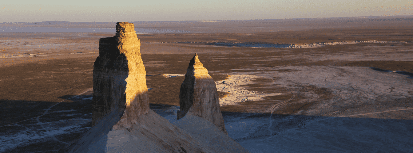
The Ungoza Mountains (Kaz. Ungozy taulary, also rendered as Ungozya) represent a scenic mesa-residual mountain massif composed of three discrete peaks in the west of Kazakhstan. This compact ridge rises on the northeastern edge of the limestone plateau within the borders of the Tupkaragan district, partitioning deep erosional basins.
This entire elevated rocky group serves as a paramount geological and landscape landmark of the Mangystau region, towering above surrounding plains with sheer cliff scarps. Just 3.1 kilometers to the north stretch sandbars where the Caspian Sea rolls its waves, washing the gentle shores of shallow Sarytash Bay.
In the expedition and tourism geography of the Tupkaragan Peninsula, the Ungoza massif occupies a strategic position as the primary panoramic high point. Approximately 135–140 kilometers to the southeast along motor highways lies the regional administrative center of Aktau, from where overland convoys travel through the suburban settlement of Akshukur and the hub village of Tauchik.
Directly at the western foot of the massif opens the grandiose Shakpaktysay Canyon with the rock-cut Shakpak-Ata underground mosque (UNESCO site), while to the east runs the valley of the Kumakapa River. Within easy reach lie the chalk canyon of Kapamsay with its mulberry grove in a grotto, Kokbulaksay defile, the Zhygylgan sinkhole, the spring-fed Tamshaly tract with weeping cliffs, the freshwater lake of Saura Canyon, and Cape Tyub-Karagan.
The geological framework of the upland is composed of thick sequences of chalk, Paleogene clays, renowned "chocolate marls," and Sarmatian coquina limestones deposited millions of years ago on the bed of the vanished prehistoric Tethys Ocean. From the base of the massif, well-worn steppe tracks head east and southeast into the interior of the Mangyshlak Peninsula: toward the sacred height of Mount Otpan-Tau with the Aday-Ata memorial, the mystical stone balls of the Torysh Valley, solitary residual Mount Sherkala, the colorful Jurassic clays of the Kokala tract, and the narrow slate gorge of Karadayirmen.
The defining feature of the massif is its tripartite structure: the upland consists of three elongated table mountains – Southern Ungoza (206.6 m), Northern Ungoza (199.2 m), and Eastern Ungoza (196.5 m), detached through long denudation from the Kaushe range and noted for historical occurrences of the mineral celestine.
After descending from the panoramic terraces of Ungoza, long-distance expeditions steer southeast toward the snow-white chinks of the Bozzhira tract, the gleaming Tuzbair salt flat, Mount Bokty, the Karynzharyk depression, and the strictly protected lands of the Ustyurt Reserve.
Today, the Ungoza Mountains are recognized as a benchmark monument of arid geomorphology and an extraordinary scenic viewpoint of Mangystau, drawing geologists, paleontologists, wildlife photographers, and road-trippers with rare minerals, monumental panoramas of white canyons, and the clean marine breeze of the Caspian basin. Near the mountain also stands the sacred Mausoleum of Khazret Sultan, which serves as a pilgrimage destination and an architectural landmark of the region.
--------------------------------------------
How to get there and visit –
The Ungoza mountain massif is situated in the northeastern sector of the Tupkaragan Peninsula, north of the Kaushe mountain range, between the Kumakapa gorge to the east and Shakpaktysay Canyon to the west, within the borders of the Tupkaragan district. The distance from the southern shore of Sarytash Bay is only 3.1 km, from the village of Tauchik – about 28–30 km to the northwest, from the town of Fort-Shevchenko – roughly 95 km, and from the regional center Aktau – approximately 135–140 km.
GPS geographical coordinates of the peaks of the Ungoza massif:
Eastern Ungoza (196.5 m):
44°26'10"N 51°13'20"E
Southern Ungoza (206.6 m):
44°25'39"N 51°12'19"E
Northern Ungoza (199.2 m):
44°26'15"N 51°12'08"E
The driving route from Aktau leads north along a paved highway via Akshukur to the settlement of Tauchik (about 95–100 km of solid asphalt). From Tauchik, the route continues northwest along a hard-packed gravel-and-steppe dirt track toward Sarytas Bay and the Shakpak-Ata complex (another 30–35 km across the plateau). The road skirts the Kaushe range and leads directly to the cols at the foot of the Ungoza mesas. Driving time from Aktau by car takes about 2–2.5 hours.
Access roads and vehicle requirements: during dry weather, passenger crossovers and high-clearance cars can carefully reach the base of the massif. However, driving directly to the steep flanks, navigating rock screes, rain ruts, and sandy-clay tracks strongly requires a prepared four-wheel-drive vehicle (4x4) with high ground clearance. During prolonged rains, the saline clay flats around the mountains soften immediately, making driving hazardous.
Foot ascent onto the plateau: climbing any of the three mesa summits requires no mountaineering gear and takes between 20 and 40 minutes from the base. The mountain flanks are steep, in places nearly vertical, composed of loose scree and stepped limestone benches. Sturdy closed trekking footwear with deep tread is mandatory. At the edge of the precipices, exercise extreme caution due to strong wind gusts and the risk of crumbling cornices.
Environmental safety rules: the Ungoza massif is a fragile geological monument.
Within the upland area, the following are STRICTLY PROHIBITED:
– Destroying ancient stone cairns (oba) or geodetic survey benchmarks on the summits;
– Painting graffiti or scratching signatures onto limestone and marl outcrops;
– Conducting unauthorized extraction of crystalline celestine druses;
– Driving wheeled vehicles off dirt tracks onto slopes, destroying the thin sod layer;
– Lighting open campfires in high winds (portable gas stoves only);
– Leaving plastic trash, glass, and tin cans.
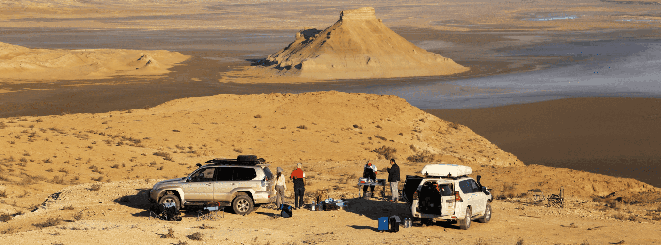
Infrastructure: the massif is an undeveloped natural landscape. Permanent guest lodges, shops, and organized campgrounds are absent. The nearest pilgrim guest house (tunehana) with an artesian well is located 5 km to the west near the Shakpak-Ata mosque. Gas stations, grocery stores, pharmacies, and tire workshops operate in Tauchik (30 km). Tent camping at the base of the mountains requires full self-reliance: drinking water (at least 5 liters per person per day), spare fuel, food supplies, windproof tents, and warm layers for chilly desert nights. On the flat summits, 4G mobile coverage connects reliably thanks to the elevation.
The best season to visit is the dry shoulder period: spring from late April to early June and early autumn in September – October. During these months, oppressive heat is absent, temperatures hover around +20...+25 °C, and clear skies offer visibility for dozens of kilometers. In July and August, the midday sun heats the rocky slopes to +38...+40 °C; summit ascents should be planned for sunrise or pre-sunset hours.
--------------------------------------------
History
The history of the Ungoza mountain massif spans geological surveys, nomadic defensive vigilance, and industrial heritage on Mangyshlak.
The name "Ungozy" (Ungoza / Ungozya) has ancient Turkic origins. In Kazakh toponymy, the first element connects to the term "ungir" (cave, grotto, weathering hollow), referencing the abundance of cavities in the mesa scarps, or traces to the name of a historical clan leader whose seasonal camps were situated near these heights.
Owing to its commanding elevation above the coastal plain, the Ungoza massif served as a key lookout point for Saka-Sarmatian nomads since the Early Iron Age. Ancient stone alignments and ritual cairns (oba) remain preserved upon the flat summits. From heights exceeding two hundred meters, scouts monitored caravan routes, cavalry movements, and approaches from the sea toward Sarytash Bay.
In the late 19th century, the Ungoza massif drew the interest of naturalists from the Russian Empire. Geological and paleontological expeditions documented rare outcrops of sedimentary rock containing druses of celestine (strontium sulfate) – a valuable mineral utilized in manufacturing and pyrotechnics.
In the late 1930s, east of the massif along the bed of the seasonal Kumakapa River (6.8 km from the mountains), large-scale construction began: a narrow-gauge railway was laid from the Sarytash maritime pier to the new coal mines of Tauchik. During the Great Patriotic War, this line ensured transport of strategic Tauchik coal to Caspian barges, while the Ungoza peaks served as visual benchmarks for train crews and convoys. In the postwar era, a geodetic triangulation pillar was erected on the northern summit, establishing precise regional survey coordinates.
Information
Morphometrically, the Ungoza massif is an erosional residual group of table mountains detached from the Kaushe range through prolonged denudation and weathering. The massif includes three distinct tabular uplands with steep, locally sheer slopes and elongated flat summit surfaces:
– Southern Ungoza is the highest peak of the group at 206.6 meters above sea level. It sits upon a basement elevation of 98 meters. The area of its cliff rim is 0.18 sq km with a scarp perimeter of 2.33 km. The summit plateau extends 909 meters in length.
– Northern Ungoza rises to 199.2 meters above sea level upon an 80-meter basement. The rim area equals 0.38 sq km, the scarp perimeter is 2.81 km, and the upper plateau length spans roughly 1.2 km.
– Eastern Ungoza reaches an elevation of 196.5 meters above sea level on a 78-meter basement, featuring the longest plateau at 3.2 kilometers. The rim area covers 1.3 sq km with a scarp perimeter of 6.66 km.
The geological section of the massif displays Paleogene and Neogene sedimentary strata. Exposures reveal alternating layers of chalk, light clays, oolitic limestones, and notable "chocolate marls" – rocks of a distinct dark-brown color. Mountain slopes contain veins and lenses of fibrous and crystalline celestine. The summits are capped by resistant Sarmatian coquina limestones.
The hydrological regime is arid. Permanent streams do not exist on the massif. Rain and snowmelt waters drain rapidly down steep flanks toward the Shakpaktysay and Kumakapa washes. Underground freshwater lenses occur at depth, feeding wells in neighboring canyons.
Soil cover is patchy: bedrock lies exposed along the scarps, while primitive gravelly gray-brown desert soils have formed across the flat summit plateaus.
The climate is sharply continental, temperate desert with steady offshore and onshore winds. In summer, daytime temperatures on the slopes reach +36...+39 °C, while in winter gale-force winds make frosts of -5...-8 °C feel significantly colder. Annual precipitation does not exceed 130–140 mm.
Detailed description of the venue
The natural and geological ensemble of the Ungoza massif encompasses the following morphological elements, summits, and observation sectors:
• Table mountain Southern Ungoza (206.6 m) – the highest conical-tabular outlier of the massif, featuring a compact summit plateau 909 meters long and sheer scarps.
• Table mountain Northern Ungoza (199.2 m) – the central panoramic bastion with a cliff perimeter of 2.81 km, opening onto a direct vista over Sarytash Bay.
• Table mountain Eastern Ungoza (196.5 m) – the most extensive outlier of the group, with a plateau stretching 3.2 km and a scarp perimeter of 6.66 km.
• Chocolate marl outcrops – dark-brown sedimentary layers in erosional slope gullies, contrasting sharply with pale limestone strata.
• Celestine mineral occurrences – historical exposures of crystalline strontium sulfate, surveyed by geologists since the late 19th century.
• Panorama of the Shakpaktysay Canyon valley – an expansive westerly vista revealing the nine-kilometer channel of the white canyon and the Shakpak-Ata mosque.
• Historic Kumakapa River valley – the broad dry wash east of the massif where the Soviet narrow-gauge railway linked the Sarytash pier with the Tauchik coal mines.
Flora and fauna
Vegetation of the Ungoza massif is adapted to gravelly, marly, and limestone substrates. The flat summits and gentle outwash slopes are dominated by gray-soil wormwood, boyalych, Anabasis salsa (biyurgun), itsigek (Anabasis aphylla), and camelthorn (dzhantak). Rock crevices and foothill hollows shelter sparse shrubs of tamarisk and spiny Caragana. In spring, the rocky slopes briefly bloom with ephemerals, dwarf wild tulips, irises, and desert grasses.
Fauna is typical of semi-desert residual uplands. Rock rifts and burrows harbor corsac foxes, badgers, steppe polecats, long-eared hedgehogs, gerbils, and tolai hares. On steep scarps and high shelves of Ungoza, small groups of Ustyurt mountain sheep (mouflons / urials), listed in the Red Data Book of Kazakhstan, graze in the morning hours.
Avifauna is represented by raptors and cliff-nesting birds. Rock doves, swifts, swallows, desert ravens, and chukar partridges nest along sheer cliff cornices. Golden eagles, steppe eagles, long-legged buzzards, saker falcons, and common kestrels soar over the summits. Isabelline wheatears and crested larks frequent the open plateaus.
Herpetofauna includes the agile steppe agama, toad-headed agama, Caspian gecko, arrow snake, and dione snake.
Invertebrates sheltering beneath flat stones on the slopes include solifuges (camel spiders), tarantulas, and steppe scorpions.
Legend
An ancient Kazakh legend tells of the Three Batyrs and the Stone Oath in connection with the Ungoza Mountains.
Tradition recounts that in centuries past, when hostile fleets sailed from the sea toward peaceful Aday settlements, three batyr brothers stood in defense of their homeland. The eldest was famed for unmatched strength, the middle brother for falcon-sharp vision, and the youngest for tireless endurance on long marches.
Before the spirits of their ancestors, they swore to stand firm on the cliff edge and bar the enemy from reaching the clan's pastures. In fierce combat, the brothers repelled hundreds of hostile warriors, covering the retreat of women and children into the haven of Shakpaktysay Canyon. When their strength waned and arrows ran dry, the brothers stood shoulder to shoulder and prayed to the Creator to turn them into stone bastions.
The earth trembled, and upon the battlefield arose three majestic table mountains. The eldest became high Southern Ungoza, the middle brother became watchful Northern Ungoza facing the sea bay, and the youngest became Eastern Ungoza, spreading his stone shoulders along the ancient caravan trails.
Ever since, local belief holds that the three summits of Ungoza keep eternal vigil over Mangystau, preserving peace and sheltering every traveler who approaches their base with a pure heart.
Conclusion
The Ungoza mountain massif is a prominent natural monument and the panoramic core of Tupkaragan, where the geometry of three tabular outliers merges with the dark hues of chocolate marls, the glint of celestine crystals, and the blue expanse of the Caspian Sea. Ascending the peaks of Ungoza offers travelers an exhilarating sense of open space, rare geological discoveries, and memorable panoramas across the ancient land of Mangystau.
Interesting sights nearby:
• Shakpaktysay (Shakpak-Ata) Canyon;
• Shakpak-Ata Underground Mosque;
• Kapamsay Canyon;
• Sarytas Bay;
• Zhygylgan Sinkhole;
• Tamshaly Gorge;
• Saura Canyon;
• Cape Tyub-Karagan;
• Tauchik Village;
• Torysh Valley of Stone Balls;
• Kokbulaksay Chalk Canyon;
• Kumakapa River Valley;
• Kaushe Mountain Range;
• Active Zholbart Well.
Sacred sights and pilgrimage destinations:
• Khanga-Baba Necropolis;
• Karaman-Ata Mosque;
• Sisem-Ata Necropolis;
• Shopan-Ata Mosque;
• Beket-Ata Mosque in Oglandy;
• Yerzhan Khazret Mausoleum;
• Karagas-Ata Necropolis;
• Koshkar-Ata Necropolis;
• Ushkan-Ata Necropolis.
Photogallery: