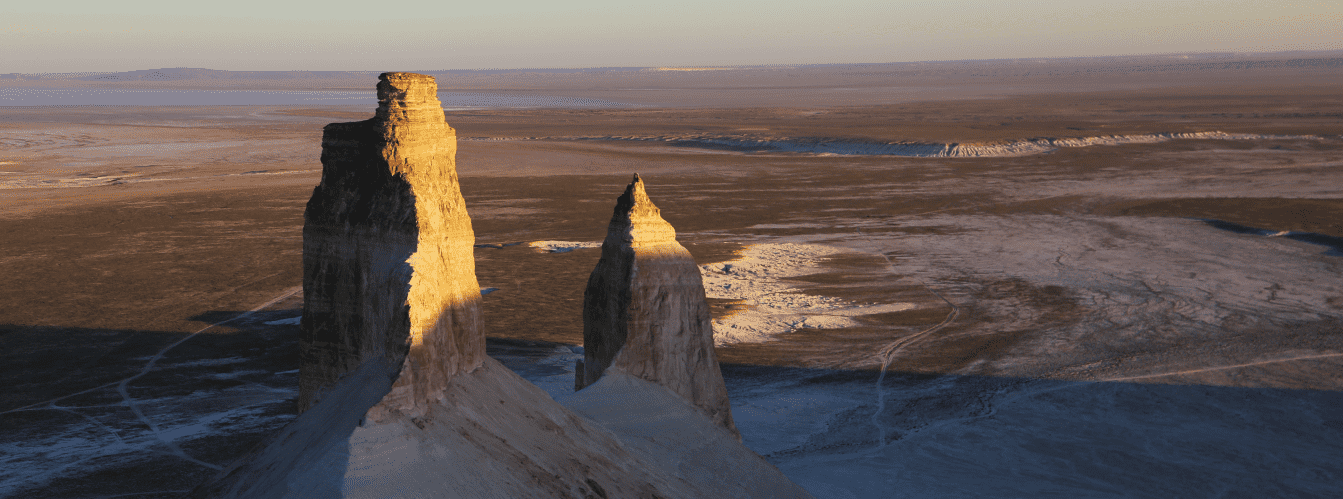
Citadel of primeval desert and the last sanctuary of Kazakhstan's rarest wildlife –
The Ustyurt State Nature Reserve (Kaz. Ustirt memlekettik tabigi qorygy) represents a benchmark conservation and scientific research institution of the highest protection category of republican significance, located in the Karakiyan district in the south of the Mangystau region.
The territory of the reserve encompasses an area of 223,342 hectares (about 2,233 sq. km), stretching latitudinally for 95 kilometers and meridionally up to 43 kilometers, bringing together the western escarpment rim of the Ustyurt Plateau, the grandiose endorheic Karynzharyk depression, the vast Kenderli salt flat, and adjoining sand ridges.
This entire grandiose territory is a direct geological legacy of the ancient Tethys Ocean: over tens of millions of years, receding marine waters laid bare thick sedimentary strata of writing chalk, Sarmatian coquina limestones, gypsum, and colored clays.
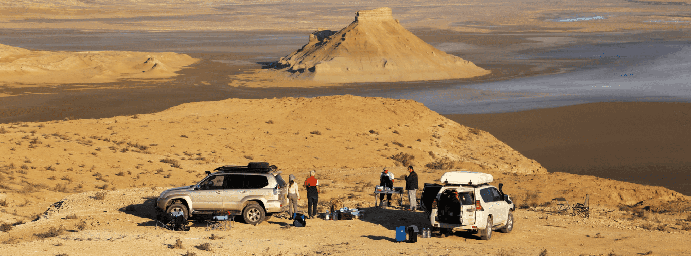
The primary landscape dominant is the Western chink of Ustyurt – a cyclopean stepped precipice with an elevation drop ranging from +340 meters above sea level (in the area of the Kugusem well) down to -52 meters at the floor of the Kenderli salt flat. During pre-sunset hours, the white, pink, and bluish walls of the chink frame the glistening salt sea, above which rise the legendary chalk Onere outliers ("Three Brothers") and the dark residual Karamaya mountain ridge.
The reserve was officially established by Decree of the Council of Ministers of the Kazakh SSR No. 294 on July 12, 1984, to preserve the natural desert complex in its undisturbed state following destructive industrial pressures during the development era of the Mangyshlak Peninsula.
The reserve has become a dependable haven for the rarest representatives of arid fauna: the Ustyurt mountain sheep (mouflon / urial), goitered gazelle, saiga antelope, caracal, honey badger, sand cat, and Pallas's cat (manul). In recent decades, camera traps along the protected trails of the reserve have regularly recorded the Persian leopard, which has occupied the ecological niche left by the Turan cheetah that went extinct in the 1960s.
Beyond the natural phenomena of Mangystau, the reserve preserves valuable monuments of ancient history: about 60 Stone Age (Neolithic) campsites, medieval Alan fortresses, the Beleuli caravanserai, and the ruins of the Shahr-i-Vazir settlement along the historic Khwarazmian highway have been recorded here.
In addition, three other large-scale conservation territories are concentrated in the Mangystau region: the Kenderli-Kayasan Nature Sanctuary, as well as the Aktau-Buzachi and Karagiye-Karakol state nature sanctuaries.
Today, the Ustyurt Reserve serves as a key natural laboratory of global significance, is inscribed on the UNESCO World Heritage Tentative List, and attracts scientists, conservationists, and travelers with the primeval stillness of its relict desert.
--------------------------------------------
How to get there and visit –
The Ustyurt Nature Reserve is situated in the remote southeastern part of the Karakiyan district in the southwestern portion of the Ustyurt Plateau: the nearest settlement – the village of Akkuduk – is 15 km from the reserve boundary, the city of Zhanaozen is 110–120 km away, and the regional center Aktau is 350–370 km away. An off-road drive from Aktau takes about 7–9 hours.
GPS geographical coordinates of the Ustyurt Reserve (cordon and Onere tract):
43°06'28"N 54°37'14"E
Entry point of the Kenderli salt flat:
42°58'45"N 54°25'05"E
Central office of the Ustyurt Reserve: address – 10 Kashagan Street, Akbulak microdistrict, Zhanaozen, Mangystau region, Republic of Kazakhstan.
Contact numbers:
+7‒729‒347‒68‒33
+7‒729‒344‒60‒06
+7‒771‒224‒38‒70
Working hours: Monday – Friday from 08:00 to 18:00 (lunch break 12:00–14:00)
Saturday – Sunday are days off.
Official website of the reserve:
https://www.ustirt.kz/
The main route from Aktau runs southeast along the paved highway of republican significance to the city of Zhanaozen (about 150 km). From there, the path follows the asphalt through the settlement of Stary Uzen to the settlement of Senek (about 60 km), after which the paved surface transitions into a difficult unpaved gravel grader and sand tracks leading to the village of Akkuduk, from where access opens to the chinks of the Karynzharyk depression.
Alternative routes across the Kenderli-Kayasan plateau entail elevated danger due to the total absence of settlements and navigational landmarks. Kazakhstan's absolute recorded temperature maximum (+47 °C) was registered at the local Akkuduk weather station.
Visiting the reserve is strictly regulated under the Protected Areas Law: independent and unorganized entry is categorically prohibited. Excursions are permitted solely along two approved educational routes accompanied by staff inspectors and guides:
1. "Kokesem" Route (vehicular-pedestrian, 440 km, 2 days): covers Zhanaozen, Senek village, Kugusem (Kokesem) well, ascent up the chink, and Kyzylsay village. Operates from March through October.
2. "Onere" Route (vehicular-pedestrian, 374 km, 1 day): covers Zhanaozen, Kulandy settlement, Akkuduk village, descent to the Karynzharyk depression, Kenderli salt flat, "Three Brothers" outliers, and the Onere spring. Operates from March through October.
Permit processing must be arranged in advance through the reserve administration in Zhanaozen, accompanied by payment of the state environmental fee. Every visitor must carry an original identity card or passport due to the proximity of the border zone.
Travel through the reserve is authorized exclusively in reliable body-on-frame expedition 4x4 vehicles with high ground clearance, heavy-duty suspension, reliable off-road tires (AT/MT), and within a convoy of at least two vehicles. Driving wheeled vehicles onto the salt crust of the Kenderli sor is strictly forbidden: a treacherous silty quagmire lies concealed beneath the crust.
Infrastructure within the reserve territory is limited to field operational facilities: ranger cordons and scientific field stations. Cellular service is entirely absent. Each vehicle crew must carry an autonomous drinking water supply (at least 5 liters per person per day), spare gasoline or diesel in jerrycans, an air compressor, two spare tires, a high-lift jack, a shovel, kinetic recovery straps, a first-aid kit, and a satellite phone.
The best time to visit is spring (from mid-April to late May), when mirror-like water stands on the floor of the depression and the steppe bursts into bloom, as well as early autumn (September – October). In July and August, scorching heat exceeding +45 °C settles across the basin with blistering desert winds, while winter brings severe snowstorms.
--------------------------------------------
History
The history of establishing the Ustyurt Reserve was the Kazakh scientific community's response to the grave environmental consequences of the 1960s–1970s industrial boom, known as the "Conquest of Mangyshlak." During this era, colossal reserves of oil, natural gas, uranium, and construction stone were discovered on the peninsula. Rapid construction of cities, laying of roads, hauling heavy drilling rigs across the steppe by bulldozers, and plans to excavate underground storage reservoirs using industrial nuclear detonations dealt an irreversible blow to the ecosystems of the Uzen and Karagiye depressions.
Under human-induced pressure and poaching, the Ustyurt mouflon population dwindled from 10,000 down to 2,000 individuals, goitered gazelle numbers collapsed from 100,000 to 10,000 head, and the Turan cheetah, which lived exclusively in this region, was completely extirpated from Kazakhstan. Saiga antelopes, caracals, MacQueen's bustards, and birds of prey faced severe extinction threats.
In 1972, by decision of the Guryev Regional Executive Committee, the Ustyurt State Sanctuary covering 53,000 ha was created near the Kugusem freshwater well on the Western chink of Ustyurt. In 1978, the "Scientific Foundations of Protected Area Management" commission of the Academy of Sciences of the Kazakh SSR substantiated the necessity of establishing a strict nature reserve spanning at least 300,000 ha.
On July 12, 1984, by Decree of the Council of Ministers of the Kazakh SSR No. 294, the Ustyurt State Nature Reserve covering 223,342 hectares was officially founded in the Yeraliyev (now Karakiyan) district. The central headquarters was established in the nearest town of Novy Uzen (now Zhanaozen).
Over decades of dedicated work, the research staff and ranger corps established regular monitoring of ungulate populations, protected raptor nesting cliffs, and preserved the relict landscapes of Karynzharyk. A sensational scientific confirmation of the sanctuary regime's success was the photographic capture by camera traps of the Persian leopard migrating along the Ustyurt chinks from neighboring Turkmenistan.
Information
Geomorphologically, the territory of the reserve covers the intersection of the Ustyurt and Mangyshlak districts of the southern desert subzone of the Turan Lowland. The relief is structured into three contrasting tiers:
1. Ustyurt Plateau – an undulating structural denudation plain rising gently toward the chink.
2. Western Chink of Ustyurt – a cyclopean stepped rock scarp stretching for dozens of kilometers, dissected by narrow gorges, canyons, grottoes, and outliers. The highest elevation of the plateau within the reserve reaches +340 meters above sea level in the Kugusem tract.
3. The Karynzharyk depression and Kenderli sor – a colossal tectonic endorheic basin about 85 km long, whose floor drops down to -52 meters below global sea level.
The geological cross-section of the area is composed of thick marine sediments from the Mesozoic and Cenozoic eras of the Tethys Ocean. The precipices of the chinks expose writing chalk, marls, Sarmatian coquina limestones, gypsum, and variegated clays. Thick strata (up to 10 meters) of self-precipitated salt, chloride-sulfate salts, and silts line the bed of the Kenderli salt flat. Fossils of ancient sea fauna – shark teeth, fossilized mollusk shells, and sea urchins – are found throughout the rocks of the chink.
Soil cover consists of gray-brown desert soils with high gypsum and salt concentrations, gravelly substrates, cracked takyrs, and the hummocky-ridge sands of Karynzharyk. Groundwater lies at depths of 0.3–0.7 meters, presenting bitter-salty brines.
The hydrological regime is characterized by the complete absence of permanent streams. Water balance is maintained by scarce springs and wells with mineralization ranging from 3 to 15 g/L:
• Onere Spring and Lake – a perennial fresh-to-brackish spring in the south of the salt flat that serves as a year-round watering hole for wildlife;
• Karazhar stream – a seasonal runoff channel in the northern portion of the Kenderli sor;
• Spring seepages at Karamai, Sarybulak, Yelshibek, and the Aytmanashi well;
• Kugusem Well – a unique water source on the reserve boundary fed by chalk strata of the chink, featuring ultra-low mineralized fresh water (0.8 g/L) and a discharge of up to 1.5–2 cubic meters per day.
The climate is sharply continental and extremely arid. In summer, daytime air temperatures exceed +40...+47 °C (reaching up to +65 °C on the soil surface), while in winter temperatures drop to -15...-25 °C accompanied by biting winds. Annual precipitation totals around 100–120 mm.
Detailed description of the venue
The natural, historical, and infrastructural complex of the Ustyurt Reserve encompasses the following unique features:
• Western Chink of the Ustyurt Plateau – a cyclopean rock wall ranging from 50 to 340 meters above sea level, composed of multi-colored strata of white, buff, pink, and bluish chalk, featuring caves, niches, and cornices.
• Endorheic Karynzharyk depression – a grand tectonic graben 85 km long lying at the foot of the chink below global sea level.
• Kenderli Salt Flat (Kendirlisor) – a colossal salt desert on the floor of the depression with a polygonal salt crust, turning into a mirrored salt sea up to 1.5 meters deep in spring.
• Onere Chalk Outliers ("Three Brothers") – a cluster of five 150-meter table rocks in the middle of the white salt flat, three of which stand closely side by side, forming the central visual emblem of the reserve.
• Karamaya Outlier Mountain and Ridge – a contrasting dark upland rising on the salt flat, composed of ferruginous sandstones, resembling the silhouette of a black recumbent camel.
• Onere Freshwater Oasis and Spring – the key year-round hydrological hub of the reserve with reed thickets, attracting herds of mouflons, saigas, and goitered gazelles.
• Kugusem (Kokesem) Freshwater Well – a pure drinking source on the crest of the chink providing fresh, low-mineralized water amid the arid plateau.
• Ancient Archaeological Landmarks – remnants of 60 Neolithic Stone Age campsites, medieval ruins of the Beleuli caravanserai, Alan fortress, and Shahr-i-Vazir town along the ancient Khiva trade route.
• Karynzharyk Sand Massif – a belt of hummocky and ridge sands with black and white saxaul groves along the eastern flank of the depression.
Flora and fauna
The flora of the reserve comprises between 263 and 336 verified species of higher vascular plants (and up to 600 species across the broader regional basin). The foundation is formed by Chenopodiaceae (49 species), Asteraceae (47), Brassicaceae (43), Fabaceae (28), and Poaceae (20 species). Clay plateaus are dominated by Anabasis salsa (biyurgun), gray-soil wormwood, and Salsola orientalis (keyreuk); gravelly terraces host Anabasis brachiata and boyalych; sand massifs feature thickets of black and white saxaul, Calligonum, sand acacia, and relict turanga (poplar). Specialized halophytic communities develop on salt flats: Halocnemum strobilaceum, Kalidium, and Salicornia.
Five rare plant species found in the reserve are listed in the Red Book of Kazakhstan: Malacocarpus crithmifolius, Crambe edentula, Rubia cretacea, Euphorbia sclerocyathium, and Salsola chiwensis.
The fauna includes 44–45 mammal species, 22 reptile species, 1 amphibian species (European green toad), and 111–166 bird species:
• Mammals: the prized asset of the reserve is the Ustyurt mountain sheep (mouflon / urial), which finds optimal cliff sanctuaries here. Saiga antelopes and goitered gazelles roam across the plains. Predators and rare species include the caracal, Pallas's cat, sand cat, honey badger, marbled polecat, Hemprich's long-eared bat, steppe polecat, wolf, jackal, corsac fox, tolai hare, long-eared hedgehog, and Brandt's hedgehog. The cheetah that once inhabited the region is extinct, but its ecological role has been assumed by the Persian leopard;
• Birds: 11 species are entered in the Red Book – MacQueen's bustard, saker falcon, peregrine falcon, golden eagle, steppe eagle, eastern imperial eagle, short-toed snake eagle, Egyptian vulture, cinereous vulture, eagle-owl, black-bellied sandgrouse, and glossy ibis. Flocks of greater flamingos, common shelducks, and waders stage on the mirrored waters of the salt flat in spring;
• Herpetofauna: Central Asian tortoise, four-lined snake, arrow snake, agile steppe agama, toad-headed and secret toad-headed agamas, plate-tailed gecko, and the venomous Halys pit viper. Solifuges, scorpions, the rare swallowtail butterfly, and desert mantises inhabit the sandy tracts.
Legend
An ancient Kazakh legend concerning the Free Mouflon and the spirit of the Kugusem chink is tied to the precipices of the Ustyurt Reserve.
Tradition tells that in the days when endless caravans of the Khwarazmshahs crossed Ustyurt, a mighty golden-horned ram named Akkulzha lived along the sheer white cliffs. He was born of the breath of the chinks and the first rays of dawn over the ancient Tethys Ocean. Elders recounted that Akkulzha guarded the secret of subterranean water sources: striking the chalk with his powerful horn, sweet fresh water would spring forth from the dry cliff, rescuing exhausted travelers and roaming herds from death.
A cruel foreign khan resolved to capture the lord of the crags to control all the springs of Ustyurt. He encircled the Kugusem cliffs with hundreds of archers and mounted hunters. Retreating along narrow ledges above the abyss of Karynzharyk, Akkulzha guided all the mountain sheep onto the inaccessible crests of the chink. When the ring of pursuers closed in, the old leader turned, cast a look of defiance at the greedy ruler, and leaped into the bottomless white expanse of the Kenderli salt flat.
Yet the titan did not perish: striking the foot of the cliff, he dissolved into the white chalk rock, and from that very spot surged the pure fresh spring of Kugusem. Struck with awe, the khan's army was blinded by the glare of the salt crystals and fled. Since then, an enduring belief lives among the people: the spirit of the golden-horned mouflon wanders the terraces of Ustyurt forever, safeguarding the protected herds from extinction and replenishing the freshwater wells across the scorching desert.
Conclusion
The Ustyurt State Nature Reserve is a monumental preserve of pristine nature on Earth, where cyclopean chalk chinks meet the silence of the Karynzharyk depression and the mirror of the Kenderli salt flat. Its protected status and scientific stewardship keep this austere wilderness intact, affording the rare opportunity to witness the flight of a golden eagle above white cliffs, the silhouettes of the "Three Brothers" outliers, and the unconstrained running of mouflons across the terraces of the ancient Ustyurt Plateau.
Interesting sights nearby:
• Karynzharyk Tectonic Depression;
• Onere Chalk Outliers ("Three Brothers" / "Three Batyrs");
• Karamaya Outlier Mountain Ridge;
• Onere Freshwater Spring;
• Ustyurt Nature Reserve;
• Basgurly Depression;
• Oil Town of Zhanaozen;
• Snow-White Chinks of the Bozzhira Tract;
• Karagiye Depression;
• Mount Borly-Tau;
• Shomanay Mountains;
• Shatkal Canyon;
• Mount Shokytau;
• Utebay Cave;
• Balayuk Cave;
• Silicon Valley in Mangystau;
• Mount Ushkirtau;
• Utebay Tract.
Sacred sights and pilgrimage destinations:
• Beket-Ata Underground Mosque in Oglandy Tract;
• Karaman-Ata Underground Mosque;
• Shakpak-Ata Underground Mosque;
• Sultan-Epe Underground Mosque;
• Otpantau Complex on Mount Otpantau;
• Kolbas Ishan Mosque;
• Koben Mosque;
• Zholaskan Mosque;
• Nurbergen Kalyshev Mausoleum;
• Zhaman Sauran Mosque;
• Ishan Khozha Mosque;
• Itolla Mosque;
• Sonabay Underground Mosque;
• Masat-Ata Mosque;
• Uytoly-Ata Underground Mosque;
• Sanctuary of Bayte.
Photogallery: