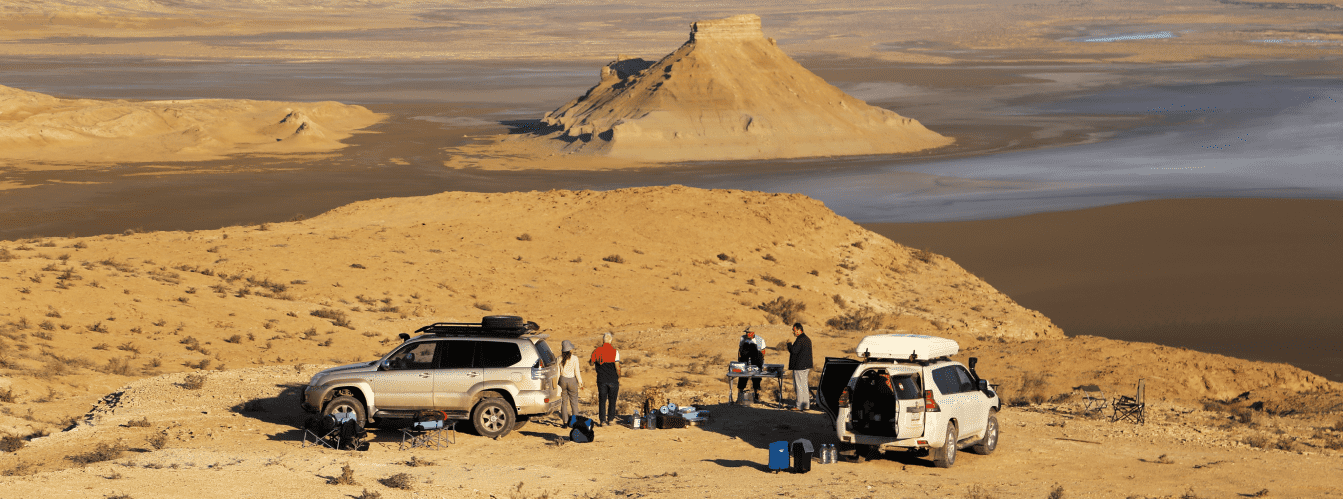
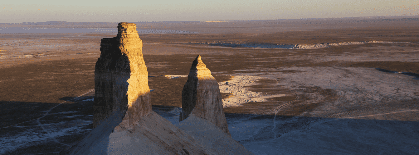
Journey to the Bozzhyra tract from Aktau is an exciting off-road route to the snow-white chalk canyons and residual mountains of the Ustyurt plateau, recognized as the natural hallmark of Mangystau.
The first panorama of Bozzhyra no. 1 is located at an altitude of 270.1 meters above sea level in the northern part of the Ortasha plateau, on the ridge of the Western chink of Ustyurt in the Karakiyan district. It is situated 4.1 km southeast of the Zhosaly mound (268.1 m) and approximately 2.8 km north of mount Shokytau. This viewpoint serves as an ideal introductory spot to appreciate the scale of the tract, offering a panoramic 360-degree vista.
From the platform, an impressive view opens up across the expanses of the Ortasha plateau and the cone-shaped mount Shokytau, standing 266 meters above sea level. To the south, directly on the slopes of the chink, rise 16-meter stone pillars sculpted by wind and water erosion. Further to the southeast, the famous mount Yurt (253.3 m high), resembling the shape of a traditional felt nomad dwelling, and the Borlytau massif are distinctly visible. Just 120–180 meters north of the viewpoint stretch the picturesque, steep slopes of the Zhosaly ravine, shimmering in the sun with cream, pink, and ochre layers of sedimentary rock.
Located 720 meters west of the first panorama along a steppe track are ancient stone hunting arans—arrow-shaped structures (Stone arrows of Ustyurt) with trapping pits used by nomads for battue hunting of saiga antelopes and goitered gazelles. Another similar aran is situated 147 meters south of the first one.
The Bozzhyra valley on the Mangyshlak peninsula is a grand natural amphitheater formed millions of years ago at the bottom of the ancient Tethys Ocean. The Ustyurt chink encircling the tract forms a natural terrace with several panoramic viewpoints, each opening a unique perspective on fanciful weathering landforms, chalk towers, and boundless salt flat plains.
List of panoramic viewpoints in the Bozzhyra tract:
• Second panorama of Bozzhyra (no. 2);
• Third panorama of Bozzhyra (no. 3);
• Fourth panorama of Bozzhyra (no. 4);
• Fifth panorama of Bozzhyra (no. 5);
• Sixth panorama of Bozzhyra (no. 6).
--------------------------------------------
How to get there and visit –
The first panorama of the Bozzhyra tract is located at an altitude of 270.1 meters above sea level in the Karakiyan district of the Mangistau region in the Republic of Kazakhstan. Geographically, the viewpoint is situated on the crest of the northern sector of the Western chink of the Ustyurt plateau, in the northern section of the Ortasha plateau.
Key local landmarks include the Zhosaly mound (268.1 m high), situated 4.1 kilometers northwest of the viewpoint, and mount Shokytau (266 m high), located 2.8 kilometers to the south and slightly east of the observation point.
GPS geographic coordinates of the first panorama of Bozzhyra no. 1:
43°27'48"N 54°02'45"E
The route from the city of Aktau follows a paved highway through the Munaily district and the town of Zhanaozen toward the underground Beket-Ata mosque. The turnoff onto an unpaved steppe track is at the 79th kilometer of the Zhanaozen – Beket-Ata highway. From the paved road to the edge of the Western chink of Ustyurt and the first panorama viewpoint, you will drive about 7 kilometers along a well-beaten steppe trail across the Ortasha plateau.
To reach the location, an equipped four-wheel-drive vehicle with high ground clearance (4x4 off-roader) is required. In dry weather, the rocky-clay plateau can be traversed reliably, but after rains, the clay softens instantly and turns into viscous ruts. You should drive strictly along established tracks without venturing onto virgin ground, in order to preserve the fragile soil cover and avoid puncturing tires on sharp limestone outcrops.
IMPORTANT: when approaching the edge of the chink, exercise extreme caution due to the danger of weathered cornices collapsing. It is also unsafe to walk right up to the edge of the drop-off.
--------------------------------------------
Tips for travelers and photographers:
• Best time for shooting: golden hour at sunrise and 1.5 hours before sunset. The low-angled sunlight highlights the topography of the Zhosaly ravine and the layering of mount Shokytau, while shadows create deep volume. At midday, the white chalk formations are strongly overexposed;
• Lens recommendations: for wide shots of the chink and the boundless Ortasha plateau, a wide-angle lens (14–24 mm) is indispensable. To capture distant residual buttes (mount Yurt and Borlytau) and weathering details, use a telephoto lens with a focal length of 70–200 mm. Be sure to use a circular polarizing (CPL) filter to cut glare from white chalk and enhance sky contrast;
• Shooting with a drone (quadcopter): launch your drone strictly from a dedicated landing pad or by hand—fine chalk dust quickly ruins motors and gimbal mechanisms. Account for powerful updrafts over the edge of the chink, which rapidly deplete battery power. Do not fly behind large butte massifs to prevent sudden radio signal loss;
• Safety at the edge of the chink: the cornices of the plateau consist of fragile, weathered limestone and can collapse under the weight of a person or vehicle. Do not drive a vehicle closer than 10–15 meters to the edge and avoid standing on overhanging rock slabs. Walking near the cliffs at night is strictly discouraged;
• Self-sufficiency and gear: there is no mobile reception on the plateau, so carrying offline maps with verified GPS tracks or satellite communicators is necessary. Bring a supply of clean drinking water of at least 4–5 liters per person per day. Footwear must feature thick, non-slip soles to guard against sharp flint fragments;
• Environmental protection: the Ustyurt plateau is a specially protected, delicate ecosystem. Driving off established tracks, leaving trash, lighting open fires on the ground, and damaging ancient stone masonry of hunting arans are forbidden. For tent camping, choose spots at the bottom of the chink that are shielded from stormy steppe winds.
Tour organization to Bozzhyra:
Our company organizes private expeditionary 4x4 jeep tours to the Bozzhyra tract from the city of Aktau, as well as comprehensive travel itineraries with transfers and meet-and-greets for guests from Almaty and other cities of Kazakhstan. Depending on your preferences, both packed single-day trips and multi-day 2–5-day safaris are available, including visits to all six chink panoramas, mount Bokty, the Kyzylkup tract, the Beket-Ata sanctuary, or an expedition into the Ustyurt nature reserve.
At travelers' service: fully prepared premium 4x4 off-road vehicles, professional drivers, certified expert guides fluent in English, Russian, and Kazakh, high-grade camping gear, field kitchens, and three hot meals daily prepared by an experienced cook.
Nearby attractions:
• Flint valley in Bozzhyra;
• Kyzylkup tract (Tiramisu);
• Senek village;
• Town of Zhanaozen;
• Uzen (Ozen) field;
• Kenderli salt flat;
• Karynzharyk depression;
• Three Brothers mountains;
• Basgurly depression;
• Zhasgurly depression;
• Kuandy depression;
• Kenderli bay;
• Kazakh bay;
• Cape Tokmak;
• Caspian Sea.
Photogallery: