Monumental table butte with sheer white cliffs above the lower Oynak plateau –
The chalk rock butte Borly-Tau (Chalk Mountain) is a monumental table upland and a striking landscape landmark in the northern sector of the Bozzhyra tract within the Karakiyan district. The morphogenesis of the massif is linked to the differential weathering of the carbonate cover following the retreat of the Mesozoic marine basin of the Tethys Ocean.
The upper tier of the mountain is shielded by a hard slab of silicified Eocene limestone, which acted as a natural protective cap. The underlying soft chalk strata of the Maastrichtian and Campanian, exposed by the tectonic fracturing of the Ustyurt plateau, were subjected to intense wind abrasion and water erosion. Water torrents severed the massif from the main Zhogarly Bozzhyra plateau, turning it into an isolated monolithic butte with steep slopes and sheer summit cliffs.
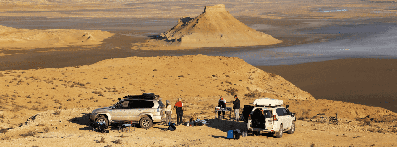
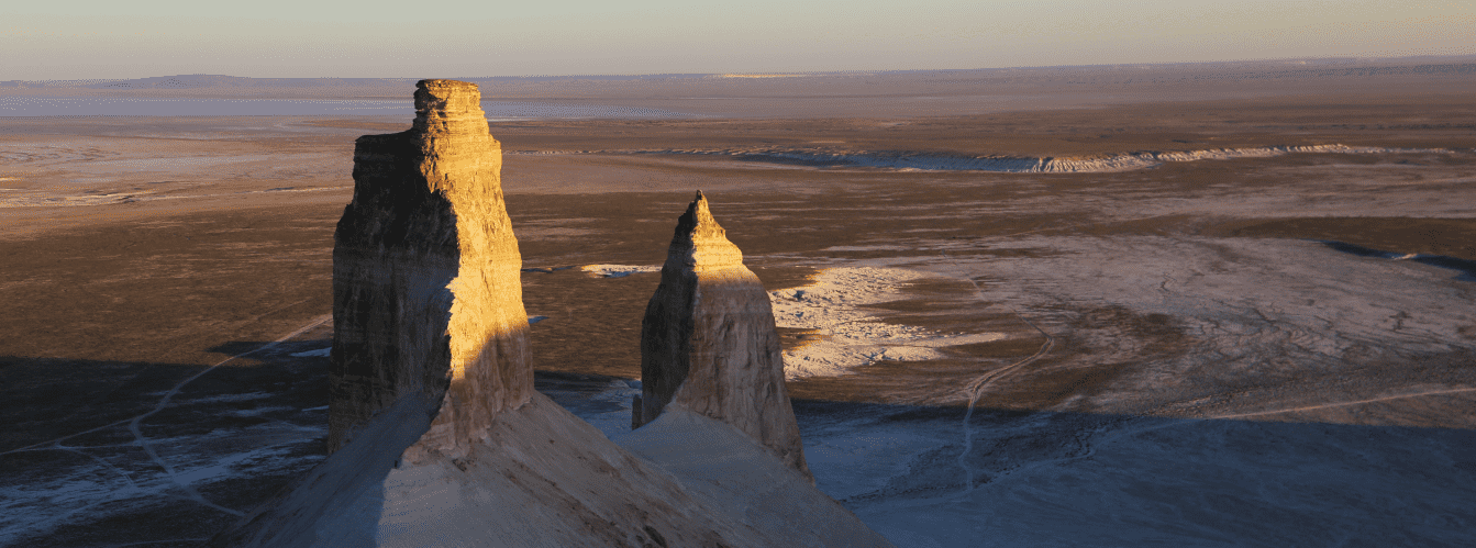
Viewed from the Oynak Bozzhyra clearing, the eastern flank of Borly-Tau looms as a cyclopean white wall blocking access to the upper scarps. The mountain is practically inaccessible for climbing: the lower tier is formed of steep, loose chalk screes, while the top is crowned by vertical rock cornices. The massif is popular among landscape photographers and overland travelers. At sunset, its white and cream tiers blaze with copper and terracotta tones, and vehicle expeditions often pitch camp at its base, which is sheltered from the harsh winds of the open plateau.
In the spatial structure of the tract, Borly-Tau towers over the lower Oynak plateau, closing the northern opening of the basin. The mountain stretches in a narrow ridge from southwest to northeast for 329 meters, with a massif width ranging from 56 to 60 meters. The elevation of the summit above the valley floor reaches 190 meters.
Geographically, the massif occupies a pivotal position relative to panoramic viewpoints: 2.7 km to the south and slightly west lies the third panorama of Bozzhyra, 2.4 km to the west and south is the fourth panorama, and 3.5 km to the southeast rises the pointed spire of Ushkiratau (Pyramid mountain). From here, steppe tracks link the site with the fang pinnacles of Azu tisteri, mount Yurt, the cliffs of the Ustyurt plateau, the Karashek salt flat, the Bokty massif, and the underground necropolises of Shopan-Ata and Beket-Ata.
--------------------------------------------
How to get there and visit –
Mount Borly-Tau is located in the Karakiyan district of the Mangistau region, in the northern part of the Bozzhyra tract basin, Republic of Kazakhstan. The distance from the city of Aktau is around 295–315 km, from Zhanaozen about 150–165 km, from the village of Senek roughly 115 km, and about 20 km in a direct line across the upper plateau scarp from the Beket-Ata mosque in Oglandy.
GPS geographic coordinates of mount Borly-Tau:
43°25'43"N 54°04'38"E
The route from the city of Aktau leads east along the A-33 paved highway through the Karagiye depression to the town of Zhanaozen (140 km). The journey then continues eastward via the settlements of Kyzylsai and Senek along asphalt toward the Beket-Ata complex (another 100 km). Before reaching the Oglandy tract, turn south onto beaten steppe ruts on the Ustyurt plateau. The descent to the lower level follows a rocky switchback in the Zhosaly tract with an elevation drop exceeding 150 meters. Once on the Oynak plain, vehicles proceed north along an established track past the towers of Azu tisteri directly to the southern foot of Borly-Tau. Total driving time from Aktau in a 4x4 off-roader is about 5 hours.
Access tracks and vehicle requirements: traveling to the base of Borly-Tau requires a body-on-frame 4x4 SUV with ground clearance of at least 220–250 mm, low-range gearing, and functional differential locks. The descent from the chink is stepped with bedrock ledges, while on the lower plateau the track traverses erosion gullies and soft carbonate silt.
Travel in passenger cars is impossible. Expeditions should be carried out with at least two vehicles for mutual support. Vehicles must be fitted with All-Terrain (AT) or Mud-Terrain (MT) tires with reinforced sidewalls. A spare tire, air compressor, tow straps, a shovel, and a farm jack with a broad base plate are mandatory.
ATTENTION: during wet conditions following spring snowmelt or rainstorms, driving on the lower tier is strictly prohibited. The chalk clay softens into a slick mud slurry within moments. Tire treads clog in a single rotation, causing the vehicle to slide off the track and bottom out on its chassis.
Walking excursions and safety: circling mount Borly-Tau on foot takes 1.5–2 hours at an easy pace. Ascending to the summit is strictly prohibited: the slopes consist of loose scree with an angle exceeding 40 degrees, and the upper limestone cornices are vertical and brittle. Attempting to climb risks slips and rockfalls.
Walking at the base requires closed-toe hiking shoes with stiff soles to protect ankles from sharp flint shards. Venomous snakes and arthropods (Pallas's coluber, steppe viper, black widow, camel spider) shelter in chalk crevices and under bushes. While camps near the mountain are sheltered from westerly winds, tents must be secured with reinforced guy lines and stakes driven deep into the ground.
Environmental safety rules: the natural complex of Bozzhyra is vulnerable to human impact.
Around mount Borly-Tau, it is STRICTLY MANDATORY TO:
– take all household trash (including cans, plastic, wet wipes, cigarette butts) back to municipal containers in town;
– stay on beaten wheel ruts without driving onto untouched ground or creating new tracks across the white soil;
– strictly avoid painting names, carving graffiti, or defacing chalk and limestone surfaces;
– avoid using local saxaul and shrubs for firewood;
– prepare food exclusively on camping gas stoves or burners;
– avoid setting up camp along the movement corridors of wild ungulates.
Infrastructure: tourist infrastructure is entirely absent in the Bozzhyra tract (no lodges, cafes, fresh water sources, shops, or mobile signal). Expeditions operate in full autonomy. Bring drinking water of at least 5 liters per person per day, utility water, spare fuel in jerrycans (at least 40–50 liters per vehicle), and a satellite phone.
The nearest fuel stations, tire repair shops, and stores are in Senek village (115 km) and Zhanaozen (150–165 km). Cellular reception at the base of the mountain is non-existent; a weak signal can be caught only on the upper rim of the Ustyurt chink.
Best time to visit is May, early June, September, and October. During these months, daytime temperatures remain within a comfortable +20...+26 °C, with cool nights. In July and August, extreme heat in the basin exceeds +40...+45 °C, and sunlight reflects intensely off the white slopes, posing a severe heat hazard.
--------------------------------------------
History
The history of mount Borly-Tau reflects the geological evolution of the Turan lowland, nomadic traditions along the Ustyurt chinks, and modern exploratory journeys.
During the Cretaceous and Paleogene periods, slow sedimentation occurred in epicontinental seas across this territory. Subsequent tectonic uplift of Ustyurt triggered deep incision by paleoriver systems. The Borly-Tau massif was originally contiguous with the high chalk plateau of Zhogarly Bozzhyra. Over millions of years, windstorms, rain torrents, and thermal weathering carved deep ravines along tectonic fault lines, severing the mountain from the parent plateau and leaving it as an isolated witness of the former land surface.
In the Middle Ages, the Borly-Tau massif and the surrounding cliffs of the chink served as landmarks along caravan routes linking the lower Volga and eastern Caspian shores with the cities of the Khwarezm oasis. From upper panoramic ledges, caravan guides charted routes toward water sources and manageable descents into the basin. For nomadic Kazakhs of the Aday clan, the tract functioned as a natural fortress: the mountain's sheer slopes and the cliffs of the chink shielded pastures from sudden raids.
The name "Borly-Tau" translates from Kazakh as "Chalk Mountain", describing the white base and slopes formed of writing chalk. In folk traditions, the mountain was revered as an unassailable fortress. Nomads believed its smooth vertical cliffs were raised by ancient spirits to guard the inner treasures of Ustyurt, and that no mortal was meant to reach the summit.
During the Soviet era, the area remained unsettled due to an absence of permanent water sources and demanding logistics. Only in the late 20th century, with the arrival of capable 4x4 vehicles, did the Borly-Tau massif become accessible to travelers. Today, the mountain is a recognized landmark of northern Bozzhyra, drawing earth science researchers and landscape photographers from around the globe.
Information
In structural and geological terms, mount Borly-Tau is an erosional-denudational butte carved into horizontally bedded strata of the Turan plate's sedimentary cover.
Morphometric characteristics:
– ridge length of the massif: 329 m aligned southwest to northeast;
– butte width in the southern part: 56 m;
– butte width in the northern part: 57–60 m;
– height of the rock massif above the valley floor: 190 m;
– height of the sheer summit cliff of the upper tier: about 20 m;
– preserved section of the structural chink surface on the northern brow: 25 m in length.
The lithological cross-section features distinct vertical zoning:
1. Lower base tier (up to 100–120 m elevation) consists of a sequence of Maastrichtian and Campanian writing chalks and light-colored marls. These soft rocks weather easily under water and wind, forming steep talus slopes embedded with gypsum crystals.
2. Middle tier is formed of alternating denser greenish-gray marls and carbonate Paleocene clays up to 40–50 m thick.
3. Upper protective tier (summit cornice) is composed of monolithic silicified Eocene limestones up to 20 m thick. The density of these rocks preserved the massif from complete erosional destruction.
Hydrogeological conditions are dry. Perennial streams and groundwater seepages are absent within the butte. Storm runoff is short-lived, draining down fluted gullies onto the floor of the Oynak valley.
The climate of the area is sharply continental and arid. Winters are frosty and windy, with average January temperatures of -7...-9 °C and strong northeasterly winds. Summers are dry with high solar insolation: average July temperatures reach +32...+35 °C (with surface air on white marl slopes exceeding +50 °C). Annual precipitation does not exceed 110–130 mm, against evaporation rates exceeding 1,000 mm per year.
Detailed site description
The natural complex of mount Borly-Tau includes the following key landscape and morphological features:
• Rock massif of Borly-Tau – a table butte 329 m long and 190 m in relative height, extending southwest to northeast and dominating the northern sector of the tract;
• Upper limestone cornice – a sheer twenty-meter cliff wall capping the massif, composed of silicified gray limestones etched with vertical weathering flutes;
• Northern structural chink fragment – a flat summit platform 25 m long on the northern end of the ridge, representing an intact remnant of the ancient Zhogarly Bozzhyra plateau;
• Eastern cliff wall – a monumental stepped slope facing the Oynak clearing, consisting of sheer drops and steep chalk ledges;
• Lower chalk scree cone – a talus apron at the mountain's base with slopes up to 40–45 degrees, composed of fine marl powder, gravel, and clear gypsum flakes;
• Network of rills and gullies (badlands) – a series of parallel micro-ravines on the western and southern slopes, carved by rainstorms into soft chalk layers;
• Camp zone at the southern promontory – a level, sheltered area at the base of the massif where it meets the Oynak plain, used for pitching tents.
Flora and fauna
Vegetation across the Borly-Tau massif is sparse due to steep gradients, ongoing slope creep, and high soil salinity. Only specialized gypsophiles and calciphiles take root on the chalk screes: black saxaul, biyurgun (Anabasis salsa), boyalych, white wormwood, and gray winterfat. At the very base, where moisture collects, tamarisk shrubs grow in isolated patches. In late April, wild Sogdian tulips, poppies, and astragalus bloom briefly on the scree slopes before withering by early June.
Wildlife is concentrated around the base and on rugged cliff ledges. Soft marls at the mountain foot support colonies of great and red-tailed gerbils, which serve as prey for corsac foxes, steppe polecats, and marbled polecats. Endangered Ustyurt mountain sheep (mouflons) traverse the slopes of Borly-Tau, finding refuge from predators on narrow rock shelves. In the mornings, saigas, goitered gazelles, and domestic herds of horses and camels graze on the adjacent Oynak plain.
Birds of prey nest on the sheer upper cliffs: golden eagles, saker falcons, long-legged buzzards, kestrels, and Egyptian vultures. Desert larks, saxaul jays, and black-bellied sandgrouse inhabit the low scrub around the base.
Herpetofauna includes rapid fringe-toed lizards, toad-headed agamas, gray geckos, and tartar sand boas, alongside venomous species—the Halys pit viper and eastern steppe viper—sheltering in rock crevices.
Legend
An ancient Kazakh legend of the White Castle of Spirits and the Sleeping Treasure of Ustyurt is associated with mount Borly-Tau.
The legend tells that when the waters of the ancient sea receded to uncover the basin floor, the master of subterranean winds erected a White Castle in the center of the plain—mount Borly-Tau. Deep within it, spirits hid a sacred book of steppe wisdom recording the destinies of nomadic clans and paths to hidden freshwater springs.
To keep mortals from claiming these secrets, the spirits made the castle walls sheer and blanketed the lower slopes with shifting white powder that gave way beneath any climber's feet. Many warriors attempted to scale the summit, but each time the mountain shook, driving them back with falling rock.
One young batyr sought to climb Borly-Tau not for riches, but to find water for his village during a drought. He approached the eastern cliff at dawn and offered a prayer to the spirits. The spirits did not grant him access to the peak, but, moved by his intent, they revealed the location of a hidden spring in nearby ravines of the chink, commanding that the mountain remain an undisturbed symbol of nature's mysteries. Since then, Kazakhs have regarded Borly-Tau as a guardian wall protecting the peace of the Bozzhyra tract, and scaling its summit is viewed as a violation of ancient custom.
Conclusion
Mount Borly-Tau in the Bozzhyra tract is a geological monument of Mangystau, combining thick sedimentary sequences with the rugged character of Ustyurt. The 190-meter white bastion viewed from the Oynak clearing, sunset colors on limestone cornices, and the silence of the desert basin leave a lasting memory for anyone journeying through Western Kazakhstan.
Nearby attractions:
• Oynak Bozzhyra clearing;
• Azu tisteri buttes (Fangs of Bozzhyra);
• Ushkiratau rock butte (Pyramid);
• Mount Yurt;
• Mount Shokytau;
• Mount Ulken-keme;
• Shatkal canyon;
• Akespe tract;
• Third panorama of Bozzhyra;
• Fourth panorama of Bozzhyra;
• Karashek salt flat;
• Picturesque mount Bokty;
• Bostankum sand massif;
• Senek sands;
• Tuzbair salt flat;
• Karynzharyk depression and "Three Brothers" buttes;
• Oil town of Zhanaozen;
• City of Aktau;
• Zhogarly Bozzhyra upper plateau.
Sacred sites of Mangystau:
• Beket-Ata underground mosque (Oglandy);
• Shopan-Ata underground mosque and necropolis;
• Karaman-ata underground mosque;
• Shakpak-Ata underground mosque;
• Sultan-epe underground mosque;
• Masat-Ata underground mosque;
• Kenty-baba necropolis;
• Sisem-ata necropolis;
• Koben mosque;
• Zholaskan mosque;
• Kolbas Ishan mosque;
• Sonabay underground mosque;
• Uytoly-Ata mosque;
• Ishan Khozha mosque;
• Bayte sanctuary.
Photogallery: