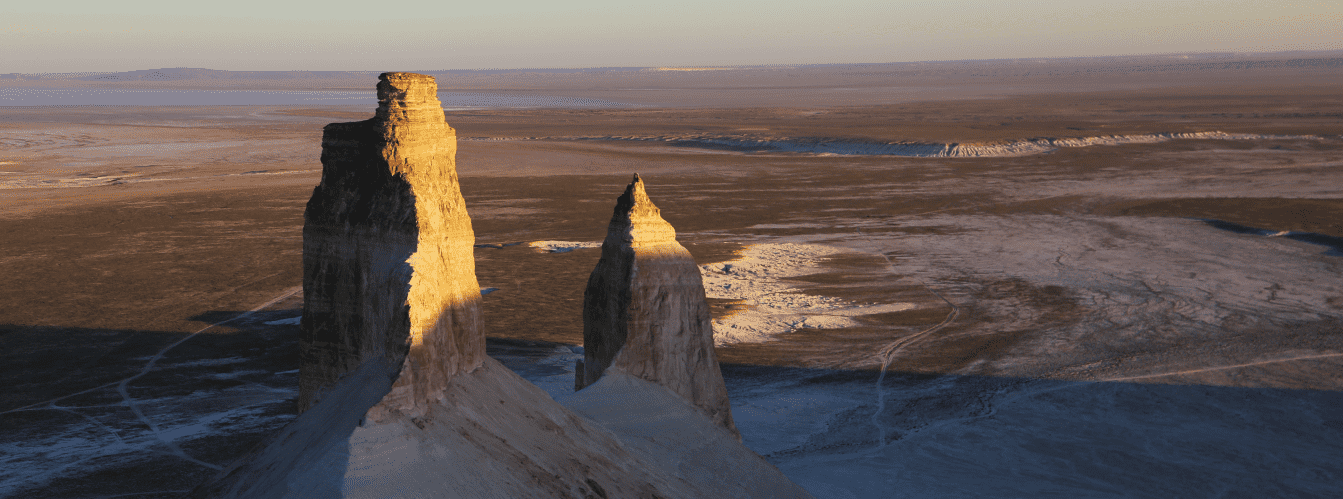
Three-tiered limestone-chalk butte between Mount Borly-Tau and Mount Bokty –
Mount Shokytau (Kazakh: Шоқы тау; also appearing in cartographic maps and guidebooks as Mount Shoku-tau) is an isolated erosional butte massif of ideal geometric form, located in the Karakiyan district of western Kazakhstan. This expressive natural monument rises in the north-central sector of the celebrated Bozzhyra tract on the surface of the Middle Plateau (an intermediate tier between the upper chink and the canyon floor of Oynak Bozzhyra), serving as one of the key geomorphological dominants of the entire landscape amphitheater.
The primary visual characteristic of Mount Shokytau lies in the striking transformation of its geometric silhouette depending on the angle of observation. Viewed from the north or south, the mountain appears as a strict, almost flawless snow-white cone or stepped pyramid, evoking associations with a traditional Kazakh yurt or a fantastical spaceship landed in the middle of the desert. From the eastern perspective, however, the massif loses its pointed contours and takes on a smoothed oval form. When viewed from above, three distinct structural terraces (ledges) composed of horizontal sedimentary rock strata stand out clearly.
The absolute elevation of Mount Shokytau's summit reaches 226 meters above sea level, producing an impressive relief above the surrounding clay-gravel plains of the lower tier. The base of the massif has an oval-elongated shape: the length of the pedestal from north to south along a submeridional axis measures 350 meters, with an east-west width of 267 meters, while the total perimeter around the foot reaches 966 meters.
In the geographic grid of the Bozzhyra tract, Mount Shokytau occupies a strategic central position: 5.3 kilometers to the east rises the sheer wall of the Western Chink of the Ustyurt plateau, 2.9 kilometers to the southeast looms the massive wall of chalk Mount Borly-Tau, 5.9 kilometers to the southeast extends the serrated crest of Mount Ushkir-tau, and 19.8 kilometers to the west-northwest stands the clear silhouette of the striped Mount Bokty. North of the massif stretches the flat surface of the Middle Plateau, crossed by a steppe track leading to the northern panoramic cliffs of the chink.
Due to its open position, Mount Shokytau is prominently visible from all elevated viewpoints of the Ustyurt chink, serving as the central visual focus of the First Panorama viewpoint of Bozzhyra. At sunset and sunrise, the white chalk slopes of the mountain catch the low sun, turning into delicate shades of gold, cream, and peach.
--------------------------------------------
How to get there and visit –
Mount Shokytau is located in the Karakiyan district of the Mangistau Region within the territory of the Bozzhyra tract and the Zhabaiushkan State Nature Sanctuary. The distance from the city of Aktau is about 280–295 km, roughly 145–150 km from the town of Zhanaozen, 2.9 km northwest of the foot of Mount Borly-Tau, 5.9 km northwest of Mount Ushkir-tau, about 3.5–4 km southwest of Mount Yurt and Shatkal-Bozzhyra Canyon, and about 4 km north of the "Fangs of Bozzhyra" rocks.
GPS geographic coordinates of Mount Shokytau:
43°26'14"N 54°02'37"E
Route from Aktau: head southeast along the paved highway through Zhanaozen toward the Oglandy tract and the underground Beket-Ata Mosque (around 240 km of asphalt). Approximately 20 km before the Beket-Ata Mosque, turn right onto a well-beaten steppe rut heading south toward the Bozzhyra chinks.
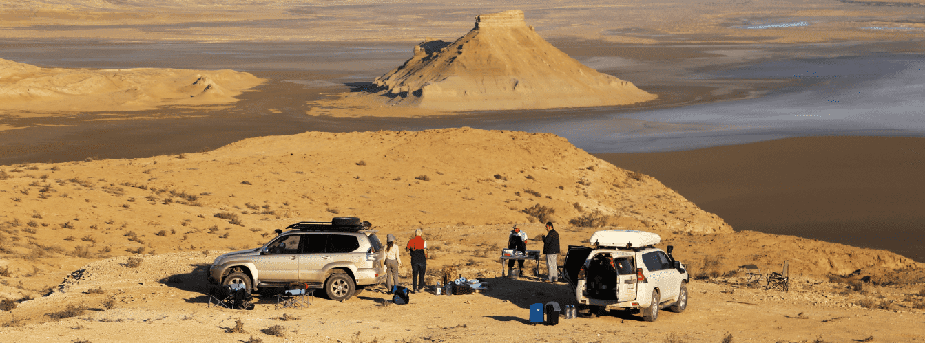
To descend to the foot of the mountain, drivers take the Zhosaly steppe descent (noted in some guidebooks as the descent toward the Zhazgurly depression) or bypass ravines near Mount Bokty. Roughly midway between the descent from the chink and the main amphitheater of Bozzhyra, a faint but established track branches off to the left. This route leads up onto the terrace of the Middle Plateau (Zhogarly Bozzhyra), running directly to the base of Mount Shokytau. Driving time from Zhanaozen by 4x4 SUV takes about 3.5–4 hours.
Walking exploration and trekking: Mount Shokytau can be approached almost to its very foot by vehicle. A popular walking route is a circular circuit around the perimeter of the mountain (a distance of about 1.2–1.5 km), which allows visitors to witness the optical transformation of the massif from a pyramidal cone into a rounded oval. Strolling around the mountain, inspecting its terraces, and searching for fossils takes between 1 and 2 hours. Climbing to the peak itself is not recommended due to the steepness and friability of the marly slopes.
Vehicle requirements: the route requires a four-wheel-drive 4x4 SUV with ground clearance of at least 220 mm and durable All-Terrain or Mud-Terrain tires. Rock slabs along the chink and gravelly stretches of the Middle Plateau alternate with chalk dust and solonchak clays. During rainy weather, driving onto the Middle Plateau is strictly discouraged: wet chalk quickly turns into a slick, sticky quagmire.
For an autonomous expedition, the vehicle must be equipped with:
– a fuel reserve for at least 300 km of off-road driving;
– two operational spare tires;
– a tire inflation compressor;
– a dynamic kinetic strap, a hi-lift jack with a wide base plate, and a shovel.
Safety precautions:
The slopes of Mount Shokytau are composed of soft chalky sediments, marl, and weathered limestone. Scaling the steep scree slopes without belaying is hazardous due to the danger of planar scree slides.
During warm periods, venomous reptiles and arthropods shelter in fissures around the base and under rocks: the Halys pit viper, Steppe ribbon racer, camel spiders (solifuges), scorpions, and black widows. Walk around the perimeter of the massif in supportive, high-top trekking boots, carefully checking resting spots.
Environmental safety rules:
– travel strictly along established steppe ruts, preserving the soil cover of the plateau;
– refrain from lighting open campfires and avoid damaging the sparse vegetation of the Zhabaiushkan sanctuary;
– avoid carving or writing on the chalk terraces of Mount Shokytau;
– pack out all household waste to permanent waste collection containers in towns.
Infrastructure: the Bozzhyra area is completely isolated from civilization: permanent hotels, cafes, fuel stations, and developed springs are absent. Cellular reception is unavailable at the foot of Mount Shokytau (intermittent reception is possible along the cliff edge at the First Panorama). The drinking water supply must be calculated at a minimum of 5 liters per person per day. Overnight tent camping can be arranged on flat clearings of the Middle Plateau at a safe distance from scree slopes.
Best time to visit is April, May, September, and October. In spring, daytime temperatures stay within a pleasant +18...+25 °C, and ephemerals bloom across the plateau. Autumn brings mild warmth and dry, firm tracks. In July and August, midday heat on the open Middle Plateau regularly exceeds +40...+43 °C, creating severe thermal stress.
--------------------------------------------
History
The history of Mount Shokytau spans tens of millions of years and is inextricably linked to the geological evolution of the Ustyurt Plateau and the retreat of the ancient Tethys Ocean.
During the Mesozoic Era and the Paleogene Period (from 65 to 30 million years ago), the territory of Mangystau formed the floor of a broad marine shelf. Over epochs, thick sedimentary sequences accumulated here: microscopic carbonate silt, composed of the skeletons of coccolithophore algae, foraminiferal shells, sea urchin tests, and belemnites, was compressed under water pressure into strata of white writing chalk and marls.
In the Neogene and Quaternary periods, the tectonic uplift of the Turan Plate caused the ancient sea to recede. The exposed plain underwent subaerial denudation and arid weathering. Linear water channels of an ancient drainage network, fierce downpours, and strong desert winds gradually carved into the plateau, stripping away soft rocks and shaping the stepped chink escarpments.
Mount Shokytau developed as a classic table-conical butte. The presence of three distinct structural terraces on its slopes is due to the lithological variation of the sedimentary beds: denser limestone layers resisted weathering more effectively, forming horizontal stepped cornices, while softer chalks and marls crumbled under gravity and rainwater erosion to produce a conical dome.
In historical times, the Bozzhyra tract was a region of seasonal migrations for nomadic clans of the Junior Zhuz (the Aday tribe). Mount Shokytau, prominently visible from the chink and caravan paths, served as a natural navigation landmark during journeys between wells and winter camps toward the Sam Sands and the Karashek salt flat. The Kazakh name "Shoky" literally denotes a sharp-topped, conical peak (a knoll), accurately reflecting the geomorphological form of the butte.
In modern times, the mountain was included in the Zhabaiushkan State Nature Sanctuary covering 316,141 hectares, securing its status as an exemplary monument of wind and water denudation across the Ustyurt Plateau.
Information
Geomorphologically, Mount Shokytau is a three-tiered erosional-denudational butte of conical type with an oval base, formed through selective weathering of subhorizontally bedded carbonate sequences of Paleogene and Upper Cretaceous age.
Morphometric parameters of the massif:
– absolute summit elevation: 226 m above sea level;
– north-south length of the base: 350 m;
– east-west width of the base: 267 m;
– base perimeter: 966 m;
– number of structural tiers (terraces): 3 clearly defined ledges;
– distance to the rim of the Western Chink of Ustyurt: 5.3 km to the east;
– distance to Mount Borly-Tau: 2.9 km to the southeast;
– distance to Mount Ushkir-tau: 5.9 km to the southeast;
– distance to Mount Bokty: 19.8 km to the west;
– hypsometric position: Middle Plateau (Zhogarly Bozzhyra level).
Lithological composition:
The structure of Mount Shokytau exposes a typical stratigraphic section of Tethys Ocean sediments. The upper cone and terraces are formed of dense silicified limestones and light-gray to pale marls that shield the summit from rapid erosion. The middle and lower tiers consist of thick beds of pure white writing chalk and carbonate clays. The gentle debris apron at the base of the mountain is covered by a deluvial mantle of rubble, flint shards, and chalk debris.
Paleontological complex:
Prehistoric fossils are found in abundance within rock exposures and screes at the foot of Shokytau:
– fossilized belemnite rostra (cephalopods);
– tests and mineralized spines of fossil sea urchins;
– petrified valves of bivalve mollusks and gastropods;
– teeth of ancient sharks from the Mesozoic and Paleogene epochs.
Climatic characteristics:
The climate is sharply continental and extremely arid. In summer, the open expanses of the Middle Plateau warm up to +42...+45 °C, with the white chalk slopes of Shokytau producing a strong reflective heat effect. In winter, temperatures can drop to -25 °C accompanied by constant, biting winds from the Ustyurt Plateau.
Detailed site description
The natural landscape complex of Mount Shokytau and adjacent structures of the Bozzhyra tract includes the following key features and panoramic locations:
• Conical summit of Mount Shokytau – a symmetrical, pointed upper chalk-denudational dome 226 meters above sea level, dominating the Middle Plateau of the tract.
• Three-tiered terrace system – three distinct horizontal steps along the slopes of the mountain composed of durable limestone and marl interbeds, encircling the massif along its entire perimeter.
• Oval base of the butte – a pedestal with a perimeter of 966 meters, extending 350 meters from north to south and 267 meters from west to east.
• Middle Plateau of Bozzhyra – a flat limestone-clay terrace of the chink (Zhogarly Bozzhyra) stretching north and west of the mountain, serving as the approach area.
• First Panorama of the Bozzhyra tract – a northern observation platform on the edge of the Western Chink of Ustyurt, offering the best panoramic perspective of Shokytau's pyramidal geometry.
• Mount Borly-Tau butte massif – a monumental table mountain with white chalk ledges, situated 2.9 kilometers southeast of Shokytau.
• Serrated crest of Mount Ushkir-tau – a wall-like butte with sharp bastions, rising 5.9 kilometers to the southeast along the margin of the Karashek salt flat.
• Zhosaly descent from the Ustyurt chink – a natural gentle pass from the upper plateau toward the Zhazgurly depression and the Bozzhyra tract, from which the track to Shokytau branches off.
• Mount Bokty butte – the famous striped butte with a truncated summit, visible along the western horizon 19.8 kilometers from Shokytau.
• "Fangs of Bozzhyra" rocks ("Azu Tisteri") – vertical limestone bastions of the lower amphitheater, located 4 kilometers south of the massif.
• Chalk deluvial aprons – gentle debris cones at the foot of the mountain, littered with marine fossils from the ancient Tethys Ocean.
Flora and fauna
Plant life around Mount Shokytau is very sparse, formed by petrophytic and xerophytic communities adapted to rubble and chalky carbonate substrates. On the stony tracts of the Middle Plateau grow eastern saltwort, boyalych, winterfat, Anabasis salsa (biyurgun), and gray wormwood. In spring, the plateau briefly comes alive with blooming ephemerals: Sogdian tulips, desert poppies, sand feather grass, and hornhead.
Wildlife is typical of the arid rocky-clay landscapes of Ustyurt. The steep slopes of the surrounding chinks and butte terraces are permanently inhabited by the Ustyurt mountain sheep (mouflon / argali), listed in the Red Book of Kazakhstan. Animals venture out onto open stretches of the Middle Plateau at dawn in search of forage.
Predatory mammals hunting in the area around Shokytau include the corsac fox, steppe wolf, badger, and the rare marbled polecat. In the gravelly screes and washouts around the base of the mountain are colonies of rodents: the great and midday gerbils, hairy-footed jerboas, and tolai hares.
Birdlife includes rare birds of prey nesting on cliff ledges: the saker falcon, golden eagle, long-legged buzzard, Egyptian vulture, and desert kestrel. Open areas of the plateau host the saxaul jay, black-bellied sandgrouse, desert wheatear, and larks.
Reptiles are represented by the rapid fringe-toed lizard, steppe agama, toad-headed agama, patterned whip snake, Steppe ribbon racer, and the venomous Halys pit viper. Scorpions, camel spiders (solifuges), and tarantulas are active in the soil during warm periods.
Legend
An ancient Kazakh legend of the Golden Tent of the Nomadic Khan is associated with Mount Shokytau.
The tale recounts that when the first nomadic encampments arrived at the cliffs of Ustyurt, one of the powerful clans was led by a fair but stern khan. He possessed countless herds of swift tulpars and flocks of sheep, and in the center of his camp stood a magnificent white yurt adorned with gold and crowned by a tall, pointed dome—a shoky.
When hordes of invaders moved against the Mangystau steppes, the khan did not retreat to the sea, but took a stand at the approaches to Ustyurt. In a fierce battle, the khan's warriors defended their homeland, though the leader himself fell to an enemy arrow. Grieving comrades resolved to preserve the memory of the great leader for centuries: they appealed to the spirits of the chinks to protect the khan's tent.
The heavens heard their prayers, and the khan's yurt, together with the three steps of the dais of honor, petrified into the snow-white Mount Shokytau. Elders believed that the khan's spirit still watches over the Bozzhyra tract, and that a traveler looking upon the cone of the mountain from the Ustyurt chink with reverence gains strength of mind, clarity of thought, and protection along distant roads.
Conclusion
Mount Shokytau is an expressive symbol of the landscape beauty of the Bozzhyra tract and a distinct geomorphological monument of the Ustyurt plateau. The combination of its regular conical form, three-tiered terraces, panoramic views from the First Panorama viewpoint of the chink, and its proximity to Mount Borly-Tau and Mount Ushkir-tau makes a visit to this butte an essential part of any expedition itinerary across the Mangistau Region.
Nearby attractions:
• First Panorama of the Bozzhyra tract;
• Second Panorama of the Bozzhyra tract;
• Third Panorama of Bozzhyra;
• Fourth Panorama of Bozzhyra (Martian);
• Fifth Panorama of the Bozzhyra tract;
• Mount Borly-Tau butte massif;
• Serrated crest of Mount Ushkir-tau;
• Chalk Mount Yurt;
• "Fangs of Bozzhyra" rocks ("Azu Tisteri");
• Bozzhyra Canyon (Shatkal Gorge);
• Middle Plateau of the Bozzhyra tract (Zhogarly Bozzhyra);
• Floor of the Oynak Bozzhyra tract;
• Zhosaly descent from the Western Chink of Ustyurt;
• Karashek salt flat and sor;
• Mount Bokty butte;
• Kyzylkup tract (Tiramisu);
• Zhabaiushkan State Nature Sanctuary;
• Beket-Ata Underground Mosque (Oglandy);
• Town of Zhanaozen;
• City of Aktau.
Sacred pilgrimage sites in Mangyshlak:
• Shopan-Ata Underground Mosque and Necropolis;
• Karaman-Ata Necropolis and Underground Mosque;
• Shakpak-Ata Rock-Cut Underground Mosque;
• Sultan-Epe Underground Mosque and Necropolis;
• Masat-Ata Underground Mosque;
• Sonabay Underground Mosque;
• Koben Mosque;
• Kolbas Ishan Mosque;
• Uytoly-Ata Mosque;
• Bayte Sanctuary.
Photogallery: