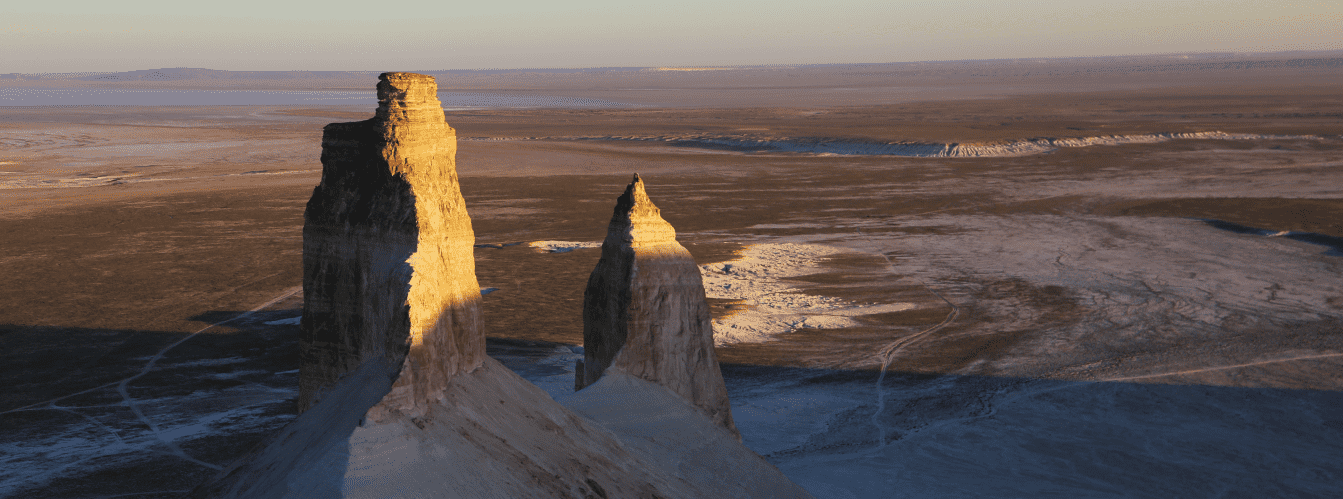
Deep erosional gorge and chalk corridor between Mount Yurt and Mount Borly-Tau –
Bozzhyra Canyon, widely known in regional toponymy as Shatkal Gorge (Kazakh: Бозжыра шатқалы; also encountered in cartography as Shatkala Canyon or the Shatkaly tract), is a deep erosional rocky corridor with sheer, layered walls, a unique geomorphological monument, and a key drainage artery of the Bozzhyra tract.
This natural rift is located in the Karakiyan district of the Mangistau Region, in the southeastern part of the Ortasha table plateau within the boundaries of the Zhabaiushkan State Nature Sanctuary.
The gorge originates at an absolute elevation of about 130 meters above sea level directly between the northern slopes of Mount Borly-Tau and the western foot of the famous dome-shaped Mount Yurt (elevation 252.3 m).
The canyon extends along a submeridional axis from south to north for a distance of approximately 1.7–1.8 kilometers, cutting into the dense marine strata of the plateau to a depth of 20 to 30 meters, with a floor width of about 50–53 meters in its southern entrance section. At a distance of 766 meters from the main entrance, the canyon channel forms a branched erosional system: a short dead-end branch 128 meters long extends to the northeast, while an extended lateral spur 426 meters long runs northwest, creating an enclosed rocky labyrinth.
The geological cross-section of Bozzhyra Canyon (Shatkal) is composed of thick carbonate strata of Upper Cretaceous and Paleogene age dating back 30 to 40 million years, which formed on the bed of the ancient Tethys Ocean. The sheer walls of the gorge expose horizontal beds of white writing chalk, dense marls, and coquina limestones filled with prehistoric marine fauna: belemnite rostra, sea urchin tests, fossilized mollusks, and teeth of ancient Mesozoic sharks.
Over millennia, vertical water erosion from meltwater and rainstorms, combined with arid weathering, cut through the soft rock, carving a deep chute with stepped rock ledges.
Owing to its significant depth and narrow channel, only a limited amount of direct sunlight reaches the interior of Bozzhyra Shatkaly. A stable shaded microclimate develops within the canyon: even at the height of exhausting summer heat, noticeable cool persists and moisture is retained, enabling the growth of localized scrub and woody vegetation unable to survive on the open, sweltering plains of the chink.
In the geographical structure of the Mangyshlak Peninsula, Shatkal Canyon acts as a connecting link across the lower tier: the western slopes of Mount Yurt drop into the ravine just 254 meters west of its dome, to the south opens the expanse of the Oynak Bozzhyra plateau and the bastions of the "Fangs of Bozzhyra" rocks, while the upper rims of the gorge are clearly visible from the observation points of the second, third, and fourth panoramas of the Western Chink of Ustyurt.
Descending onto the stony floor of the canyon, travelers find themselves in complete visual seclusion: flat steppe horizons give way to sheer snow-white and ochre walls, while the silence is broken only by gusts of wind and the calls of birds of prey nesting in natural weathering cavities.
Toponymy and name variants
In guidebooks, cartographic databases, and expedition reports, this natural site is referenced under several names, which frequently creates confusion for travelers:
• Bozzhyra Shatkaly – the historical Kazakh designation. The word "шатқал" translates as "gorge," "ravine," or "canyon," literally meaning "the gorge of the Bozzhyra tract."
• Shatkal Canyon (or Shatkala Canyon) – the most common designation in Russian-language literature and on travel maps, derived by adapting the Kazakh term "шатқал" as a proper name. From a linguistic perspective, the construct forms a pleonasm ("Gorge Canyon"), yet it has become firmly established as an official geographic reference.
• Bozzhyra Canyon – the name adopted along international expedition routes and overview cartographic maps, generalizing the entire erosional rift that cuts through the Ortasha table plateau at the foot of Mount Yurt.
--------------------------------------------
How to get there and visit –
Bozzhyra Canyon (Shatkal Gorge) is located on the southeastern margin of the Ortasha plateau in the Karakiyan district of the Mangistau Region in Kazakhstan. The distance from the city of Aktau is around 270–300 km, roughly 140–150 km from the town of Zhanaozen, 254 m west of the foot of Mount Yurt, about 200–300 m from the northern slopes of Mount Borly-Tau, roughly 3.5 km northwest of the "Fangs of Bozzhyra" rocks ("Azu Tisteri"), and 12 km north of the Karashek salt flat.
GPS geographic coordinates of Bozzhyra Canyon (Shatkal):
43°26'07"N 54°04'25"E
The route from Aktau leads along a paved highway through Zhanaozen toward the underground Beket-Ata Mosque (Oglandy)—totaling about 240 km of paved surface. Twenty kilometers before the Oglandy tract, turn south into the open steppe toward the Bozzhyra chinks.
To reach the entrance of the canyon, take the descent to the lower plateau of the Oynak tract via the bypass steppe ravines near Mount Bokty or the descents from the Ortasha plateau. Approach to the gorge is made from the floor of the tract, heading toward the intermontane saddle between the Yurt and Borly-Tau massifs, where the entrance to the rift opens. The steppe ruts consist of loamy and gravelly sections covered with a layer of chalk dust. Driving time from Zhanaozen takes between 3.5 and 4.5 hours depending on road conditions.
Regulations and documents: the Bozzhyra tract and the Zhabaiushkan sanctuary are open for tourism and do not require a special border permit. Visitors must carry original identification documents (Kazakhstani citizens must have national ID cards; foreign tourists must have passports). If the expedition includes a visit to the adjacent territory of the Ustyurt Reserve (the Karynzharyk depression, the Kenderlisor salt flat), entry permits must be arranged in advance at the reserve administration in Zhanaozen.
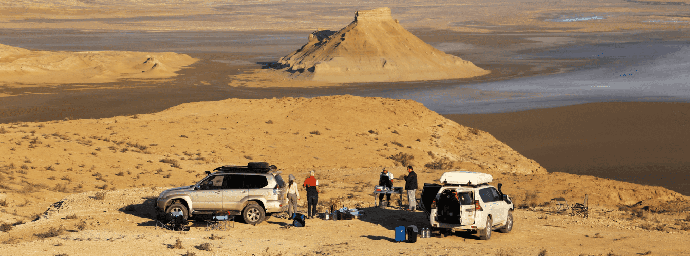
Vehicle requirements: access is possible exclusively in four-wheel-drive 4x4 off-road vehicles with ground clearance of at least 220–250 mm, fitted with reliable AT or MT tires. Inside the canyon itself, driving is impossible due to the rugged terrain and strictly prohibited by conservation regulations; vehicles are parked on the staging area before the entrance. Driving across the clay soils of Bozzhyra during wet weather is hazardous: wet chalk instantly turns into a slick slurry that immobilizes wheeled vehicles.
Expeditions to remote points of Bozzhyra should be carried out in a group of at least two prepared vehicles. Each vehicle must carry an autonomous fuel reserve for at least 400 km of off-road driving, two operational spare wheels, an air compressor, a kinetic recovery strap, a hi-lift jack, sand ladders, and digging tools.
Safety precautions and hiking rules:
On-foot exploration of Shatkal Gorge requires attentiveness and caution. The walls of the canyon consist of loose marls and weathered chalk strata prone to spontaneous rockfalls and scree slides. Approaching unstable overhanging cornices and attempting to scale the vertical chalk walls without specialized climbing gear is strictly prohibited.
Navigating the canyon floor requires high-top trekking boots with rigid soles to protect feet against sharp flint shards and loose rock.
During torrential rains or thunderstorm warnings, descending into the canyon is strictly forbidden: the narrow channel can fill within minutes with fast-moving flash mudflows collecting runoff from the entire surface of the Ortasha plateau.
Venomous wildlife inhabits wall crevices, spaces beneath stones, and floor vegetation: the Halys pit viper, Steppe ribbon racer, scorpions, camel spiders (solifuges), and black widows. When moving through the area, inspect resting sites carefully and avoid reaching blindly into rock fissures.
Environmental safety rules:
Within Shatkal Canyon and the Zhabaiushkan sanctuary, it is STRICTLY MANDATORY TO:
– preserve the integrity of the natural gorge floor and travel exclusively on foot;
– carry out all generated household waste;
– refrain from lighting campfires or using the sparse floor vegetation for firewood;
– avoid carving graffiti or writing on the chalk and marly walls of the gorge;
– respect the nesting areas of rare raptors in the cliff niches.
Infrastructure: the Bozzhyra area is entirely autonomous; tourist services, hotels, fuel stations, and drinking water sources are absent. Mobile phone reception is unavailable on the canyon floor. Drinking water must be brought along, calculated at a minimum of 5 liters per person per day. Tent camps are pitched on the lower plateau outside the gorge in open areas, maintaining a safe distance from scree slopes.
The best time to visit is April, May, September, and October. In spring, the canyon floor is carpeted with fresh vegetation, temperature swings are moderate, and daytime air warms to a comfortable +18...+25 °C. In autumn, the heat recedes, and unpaved roads remain dry and firm. From June through August, temperatures in direct sunlight across Bozzhyra exceed +40...+45 °C, and while the canyon walls provide shade, the overall heat load remains extreme.
--------------------------------------------
History
The history of Bozzhyra Canyon (Shatkal) reaches back tens of millions of years into geological time, linking the retreat of the prehistoric Tethys Ocean with the nomadic pathways of ancient Mangystau.
During the Mesozoic Era and the Paleogene Epoch (from 70 to 30 million years ago), the territory of modern Mangyshlak and the Karagiye depression formed the floor of the deep oceanic Tethys basin. Over epochs, multi-meter strata of carbonate silts composed of mollusk shells, calcareous plankton, and the skeletons of marine life accumulated on the seabed. Following tectonic uplifts of the earth's crust, the sea retreated, exposing horizontal beds of white chalk and marl.
In the Quaternary Period, deep water erosion played the decisive role in sculpting the modern profile of the gorge. In an arid climate, sparse rainstorms generated immediate surface torrents across the impermeable limestones of the Ortasha plateau. Runoff channeled along lines of least resistance following tectonic micro-fissures, carving into the soft sedimentary sequences. Over hundreds of thousands of years, water erosion cut a trench up to 30 meters deep, creating the scenic Bozzhyra Shatkaly gorge.
In historical times, the canyon served as a natural shelter for the nomadic clans of Mangystau. During seasonal migrations across the Ustyurt plateau, the narrow Shatkal defile sheltered people and flocks of sheep from dust storms and gale-force winds. On the cliff faces of the chinks surrounding the gorge, archaeologists have documented ancient petroglyphs, tribal tamgas, and remnants of temporary encampments dating from the Bronze Age to the early Middle Ages.
In the modern era, the canyon became part of the Zhabaiushkan State Nature Sanctuary covering 316,141 hectares, serving as an exemplary site for studying Paleogene stratigraphy and the arid erosion of the Ustyurt plateau.
Information
Geomorphologically, Bozzhyra Canyon (Shatkal) is a deeply incised linear erosional rift of canyon-like profile cut into the horizontally bedded limestone-chalk deposits of the Ustyurt plateau.
Morphometric indicators:
– total length of the main channel: from 1.7 to 1.8 km;
– incision depth in the central part of the gorge: from 20 to 30 m;
– channel width in the southern entrance section: from 50 to 53 m;
– absolute elevation of the entrance: about 130 m above sea level;
– length of the northeastern side branch: 128 m (766 m from the entrance);
– length of the northwestern side branch: 426 m;
– distance to the western foot of Mount Yurt: 254 m to the east;
– elevations of surrounding massifs: up to 252.3 m (Mount Yurt).
Lithological structure:
The canyon walls expose a stratigraphic cross-section of the Upper Cretaceous and Paleogene periods. The upper structural tier of the plateau consists of durable silicified limestones that resist sheetwash erosion. The middle and lower sections of the walls are formed of white writing chalks and clayey marls that weather easily under water erosion, forming smooth vertical faces, cornices, and wind niches. The canyon floor consists of gravel-rubble deluvium with lenses of carbonate clay and scatters of flint.
Paleontological complex:
Fossils from the Tethys Ocean are abundant in the wall exposures and floor sediment of the canyon:
– belemnite rostra (extinct cephalopods);
– fossilized tests and mineralized spines of sea urchins;
– imprints and valves of bivalve mollusks;
– silicified fragments of colonial corals;
– teeth of fossil sharks from the Paleogene and Cretaceous periods.
Microclimatic conditions:
The climate of the region is ultra-arid and sharply continental. However, because the high walls shield the channel from direct sunlight, daytime temperatures at the canyon floor are 5–8 °C cooler than on the open plateau surface, and residual moisture evaporates at a much slower rate.
Detailed site description
The natural landscape ensemble of Bozzhyra Canyon (Shatkal) and adjacent structures of the tract includes the following key features and panoramic locations:
• Erosional channel of Shatkal Canyon (Bozzhyra Shatkaly) – a winding rock chute 1.8 km long with vertical chalk walls up to 30 meters high, set between Mount Yurt and Mount Borly-Tau and serving as the primary drainage corridor of the Ortasha plateau.
• Northwestern side branch – a rocky spur 426 meters long branching off 766 meters from the southern entrance, characterized by pronounced shade, a narrow floor, and substantial marl screes.
• Northeastern dead-end branch – a short rift 128 meters long with a sloping bed, terminating in a vertical erosional headwall over which seasonal storm runoff drops from the plateau.
• Chalk butte of Mount Yurt – a standalone dome-shaped massif 252.3 meters high, whose western slopes approach to within 254 meters of the Shatkal gorge rim, forming the eastern wall of the entrance amphitheater.
• Mount Borly-Tau butte – an extended table upland with stepped chalk ledges, forming the western frame of the canyon's entrance group.
• Ortasha plateau – an extensive flat limestone step of the chink that forms the catchment area of the canyon, offering an overhead view of the fissure network cutting through the surface.
• Flat floor of Oynak Bozzhyra – an open clay-gravel expanse at the southern exit of the canyon, from where approach tracks lead toward the residual rock spires.
• "Fangs of Bozzhyra" rocks ("Azu Tisteri") – two vertical limestone spires about 200 meters high, dominating the southern view at a distance of roughly 3.5 km from the mouth of the gorge.
• First panorama of the chink – a northern observation point looking over the outer limestone contours of the tract and the entrance group of the canyon system.
• Second panorama of the chink – an elevated ledge of the Western Chink of Ustyurt offering the clearest vantage point on the structural layout of Shatkal Canyon, its depth, and its branching points across the Ortasha plateau.
• Third panorama of the chink – an observation point on the edge of the plateau showing Shatkal Canyon framed alongside the dome of Mount Yurt and the lower amphitheater.
• Fourth panorama of the chink (Martian) – a celebrated vantage point above the cliff edge, tracing the junction of the canyon's drainage network with the rock cirques of Bozzhyra.
• Aeolian grottoes and niches of the canyon – hollows and wind-eroded pockets in soft chalk layers, providing shelter for raptors and small mammals.
• Paleontological horizons of the Tethys Ocean – outcrops of marine bottom sediments containing dense beds of belemnite rostra, shark teeth, and fossil shells.
Flora and fauna
Plant life within the Bozzhyra Shatkaly gorge is noticeably richer than the surrounding semi-desert, thanks to shading and the collection of moisture at the bottom of the rift. Individual specimens of shrubs and stunted trees grow here: tamarisk (crested tamarisk), Schober's nitrebush, boyalych, and winterfat. Along the edges of chalk screes grow communities of eastern saltwort, white and gray wormwood, and Anabasis salsa (biyurgun). In early spring, the canyon floor is briefly carpeted with ephemerals: wild Sogdian tulips, hornhead, and poppies.
Wildlife is characteristic of the rocky-arid complexes of Mangystau. The sheer chalk walls of Shatkal Gorge offer secure nesting ledges for birds of prey: the rare saker falcon, golden eagle, Egyptian vulture, and common kestrel. Rock doves, desert wheatears, ravens, and little owls inhabit fissures in the rock.
Among mammals, the Ustyurt mouflon (argali) regularly frequents the rocky shelves of the canyon and adjacent chink slopes, finding safety from predators. At night, corsac foxes, wolves, marbled polecats, and badgers enter the gorge floor. Gerbils, voles, jerboas, and long-eared hedgehogs nest in rock piles.
Reptiles include the toad-headed and spotted toad-headed agamas, rapid fringe-toed lizard, steppe agama, Steppe ribbon racer, and the venomous Halys pit viper. During the warm months, venomous arthropods are active among stones and fissures: camel spiders, scorpions, and black widows.
Legend
An ancient Mangystau legend of the Lost Stream of Coolness is told of Bozzhyra Canyon (Shatkal Gorge).
The tale recounts that in immemorial times, when the spirit of a great drought sought to wither the pastures of Ustyurt, the nomadic elders appealed to the spirits of the chinks to protect their springs and flocks. Hearing their call, subterranean forces split the snow-white bedrock of the plateau with a mighty stroke, creating the deep, cool defile of Shatkal.
According to the legend, a subterranean stream that held the cool depths of the retreated Tethys Ocean flowed along the bed of this cleft for generations. During severe storms and the scorching midday heat, nomads sheltered their livestock here, while healers gathered rare medicinal herbs growing only in the perpetual shade of the chalk cliffs. Local people believed that the gorge held the spirit of ancient sea waters, and that anyone entering beneath its vaults with pure thoughts would clear their mind of worries and gain the resilience of Ustyurt's cliffs.
Conclusion
Bozzhyra Canyon (Shatkal Gorge / Bozzhyra Shatkaly) is an exceptional natural monument of arid erosion and a landscape highlight of the Ustyurt plateau. The combination of monumental chalk walls, a cool microclimate, a rich paleontological record of the Tethys Ocean, and its immediate proximity to Mount Yurt makes the gorge an essential part of any expedition route through the Mangistau Region.
Nearby attractions:
• Mount Yurt in the Bozzhyra tract;
• Mount Borly-Tau butte;
• "Fangs of Bozzhyra" rocks ("Azu Tisteri");
• Floor of the Oynak Bozzhyra tract;
• Mount Ulken Keme;
• Mount Shokytau;
• Mount Ushkirtau;
• First panorama of Bozzhyra;
• Second panorama of Bozzhyra;
• Third panorama of Bozzhyra;
• Fourth panorama of Bozzhyra;
• Fifth panorama of Bozzhyra;
• Sixth panorama of Bozzhyra;
• Karashek salt flat and lake;
• Kyzylkup tract (Tiramisu);
• Bokty butte mountain;
• Town of Zhanaozen;
• City of Aktau;
• Ortasha plateau;
• Zhabaiushkan State Nature Sanctuary.
Sacred pilgrimage sites in Mangyshlak:
• Shopan-Ata underground mosque;
• Karaman-ata underground mosque;
• Shakpak-Ata underground mosque;
• Sultan-epe underground mosque;
• Kenty-baba necropolis;
• Sisem-ata necropolis;
• Otpan-tau memorial complex;
• Masat-Ata underground mosque;
• Sonabay underground mosque;
• Koben mosque;
• Kolbas Ishan mosque;
• Uytoly-Ata mosque;
• Bayte sanctuary.
Photogallery: