Glistening salt sea of the Karynzharyk depression and the protected heart of Ustyurt –
The Kenderli Salt Flat (Kaz. Kendirli sory, Kendirlisor) represents a grandiose endorheic salt depression, a colossal salt desert covering over 50,000 hectares (500 square kilometers), and one of the most magnificent landscape phenomena of Kazakhstan, located in the Karakiyan district in the southeast of the Mangystau region.
Occupying the bottom of the tectonic Karynzharyk depression, which extends for 85 kilometers, the Kenderli sor together with adjoining hummocky-ridge sands forms a unique enclosed natural basin under the strict protection of the Ustyurt State Nature Reserve.
This entire immense basin is a direct geological legacy of the ancient Tethys Ocean, which surged across these expanses tens of millions of years ago: receding relict marine waters evaporated within deep tectonic downwarps, leaving behind colossal strata of rock salt, gypsum, and salt-bearing clays.
The transition from the flat clay-gravel plains of the Ustyurt Plateau to the depression is astonishing in its suddenness: the endless undulating steppe drops off abruptly along a monumental cliff scarp – a chink, laying bare multi-layered walls of white chalk, limestone, clay, and sandstone. In the pre-sunset hours, the salt flat appears as a blinding white mirror, against which the dark residual outlier Karamaya mountain ridge towers like a black castle emerging from nowhere.
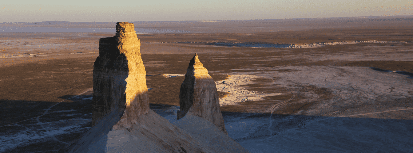
The landscape of the Kenderli salt flat displays pronounced seasonal dynamics. During cold months, spring snowmelt, and rare torrential rains, the impermeable clay floor fills with water, creating an expansive yet shallow water body up to 1.5 meters deep. This mirror-like surface reflects the sky, white Ustyurt chinks, and the legendary 150-meter Onere outliers with crystal clarity, three of which stand closely side by side and are known as the "Three Brothers" (or "Three Batyrs").
With the onset of summer heat, the water evaporates to expose the cracked crust of a takyr, beneath whose thin layer lies treacherous liquid saline mud. In the southern sector of the sor, sustained by the permanent Onere spring, the lake never dries up completely, providing an oasis and watering hole for rare desert wildlife.
The sor derived its Kazakh name from the fibrous dogbane plant (Kaz. kendir), which historically grew in sandy hollows and near springs and was used by nomads to weave strong ropes and cordage.
Today, the Kenderli salt flat in the basin of Karynzharyk is recognized as one of the most remote, pristine, and photogenic natural landmarks of Eurasia, attracting expedition teams, geomorphologists, and landscape photographers from around the globe.
--------------------------------------------
How to get there and visit –
The Kenderlisor salt flat is situated in the remote southeastern part of the Karakiyan district of the Mangystau region, within the territory of the Ustyurt Reserve, 24.4 km east of the settlement of Akkuduk (Ak-Kuduk), 72.2 km east of the Basgurly depression, approximately 230 km southeast of the city of Zhanaozen, and 370–380 km southeast of the regional center, the city of Aktau. A one-way drive by car takes between 7 and 9 hours.
GPS geographical coordinates of the Kenderli salt flat (Kendirlisor):
42°53'31"N 54°22'44"E
42.979233, 54.418131
The primary driving route from Aktau leads southeast along the paved republican highway to the city of Zhanaozen (about 150 km). From there, continue south on asphalt toward the settlement of Senek (about 60 km), where the paved road ends. The route then traverses rough sand-gravel steppe graded roads and worn tracks through the settlement of Akkuduk toward the chinks of the Karynzharyk depression.
Because the Kenderli sor lies within the strictly protected core zone of the Ustyurt State Nature Reserve, access here is strictly regulated: entry is permitted only as part of organized travel groups holding an official permit issued by the reserve administration (located in Zhanaozen), and exclusively in the company of a state inspector.
Each visitor must carry original identity documents (identity card or passport), as the area lies in proximity to the state border zone.
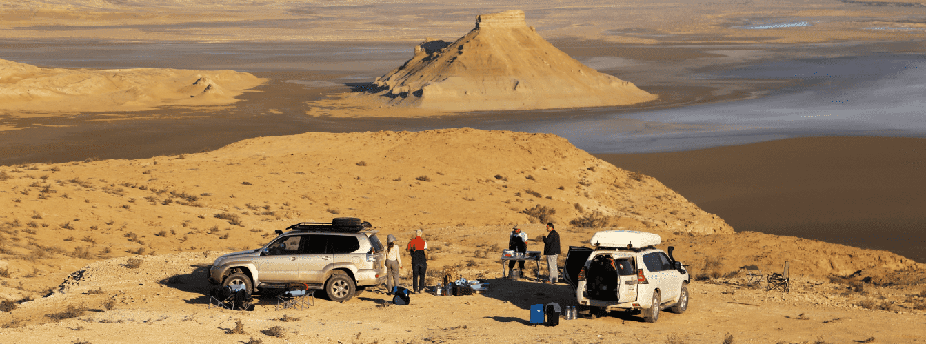
Travel is possible strictly in prepared expedition body-on-frame four-wheel-drive vehicles (4x4) with high ground clearance, heavy-duty suspension, reliable off-road tires (AT/MT), and in a convoy of at least two vehicles.
Driving vehicles onto the surface of the salt flat is categorically forbidden: beneath the dry surface lies a bottomless saline bog into which a heavy vehicle sinks instantly.
Walking on the crust of the sor also requires extreme caution.
Infrastructure at the site is completely absent: this is an entirely wild, self-contained wilderness. Mobile phone networks do not function. The nearest gas stations, shops, tire repair workshops, and hospitals are in the city of Zhanaozen. The autonomous equipment inventory of each vehicle crew must include drinking water calculated at no less than 5 liters per person per day, extra fuel in jerrycans, two spare tires, an air compressor, kinetic recovery ropes, a medical kit, high-SPF sunscreen, and a satellite phone.
The best time to visit is spring (from late April through May), when the depression is filled with water, creating a multi-kilometer mirror reflecting the "Three Brothers," the surrounding steppe turns green, and temperatures remain comfortable. In summer (July and August), extreme heat above +45...+48 °C prevails, the sor dries out, and salt dust and blinding sunlight make staying in the basin exceedingly taxing. In winter, hurricane-force freezing winds scour the chinks.
--------------------------------------------
History
The history of the Kenderli salt flat spans millions of years, joining the geological desiccation of the Tethys Ocean with the pathways of Eurasian nomadic civilizations. The Karynzharyk depression formed as a result of large-scale tectonic subsidence of the Earth's crust, which produced an immense endorheic basin where surface and groundwater from the surrounding Ustyurt Plateau accumulated.
In antiquity and the Middle Ages, the Kenderli salt flat presented an impassable barrier for merchant caravans and military detachments. Travelers journeying from Khwarazm and Khiva toward the Caspian coast were forced to skirt the sor from above along the edge of the chink or make their way through the sand ridges of Karynzharyk, guided by the dark, distant summit of Mount Karamaya. The only life-saving oasis in the southern sector was the Onere spring, around which shepherds and hunters found shelter for centuries.
In the sands along the margins of the depression, nomads of the Aday clan grazed livestock seasonally and harvested kendir – a bast fiber plant whose durable fibers were used in daily life to make ropes, lassos, and fishing gear.
In the 19th century, the white scarps of the Karynzharyk depression and the Kenderli sor were surveyed and mapped on military topographic charts by expeditions of the Russian Empire led by explorers E. A. Eversmann and G. S. Karelin.
During the Soviet era, the unique landscape and relict fauna prompted the need for state protection of the territory: on July 12, 1984, the Ustyurt State Nature Reserve was established, incorporating the Kenderli sor and the Karynzharyk chinks into its core reserve zone to preserve populations of mouflons, saiga antelopes, goitered gazelles, and the Asiatic cheetah.
In the 21st century, the Kenderli salt flat became a globally recognized destination for off-road expeditions across Mangystau, remaining an enduring benchmark of untouched wilderness in Kazakhstan.
Information
Geomorphologically, the Kenderli salt flat is an extensive tectonic endorheic basin-sor occupying the central and southern parts of the Karynzharyk depression. The length of the entire depression system is approximately 85 kilometers, with the area of the Kenderli salt flat itself exceeding 50,000 hectares (over 500 sq. km). The floor of the depression lies at elevations significantly below the surrounding Ustyurt Plateau, reaching depths of up to 75 meters below sea level.
The geological cross-section of the depression walls features a thick stratified complex of Neogene, Paleogene, and Upper Cretaceous marine formations. The chinks are composed of writing chalk, marls, light-colored coquina limestones, and colored clays. Aeolian deflation and water erosion have sculpted fantastical weathering forms here: rock cornices, pillars, castles, caves, and suspended spherical concretions. The rock outcrops and screes contain paleontological artifacts from the ancient Tethys Ocean: teeth of prehistoric sharks, fossil mollusk shells, and sea urchins.
The floor of the sor is lined with thick beds of self-precipitated salt (halite), gypsum, and saline muds. The salt flat is fringed by the hummocky-ridge sands of Karynzharyk and the dark massif of Mount Karamaya, which is composed of ferruginous rocks.
The hydrological regime of the sor is pulsating in character:
1. Winter-spring period: the accumulation of snowmelt and rainwater transforms the sor into an expansive endorheic water body up to 1.5 meters deep.
2. Summer period: rapid moisture evaporation triggers salt crystallization and the formation of takyrs – a hard, cracked crust concealing liquid saline mud.
3. Permanent Onere waterbody: a copious freshwater spring wells up in the southern sector of the sor, ensuring that the salt lake in this sector never dries up completely year-round.
The climate of the area is extremely arid and sharply continental. In summer, air temperatures at the floor of the depression routinely climb above +45 °C, creating optical mirages and intense heating of the salt fields. In winter, temperatures drop to -20...-25 °C accompanied by gale-force winds.
Detailed description of the venue
The natural landscape complex of the Kenderli salt flat includes the following unique features and zones:
• Snow-white salt field of the Kenderli sor – a grandiose salt desert spanning over 50,000 ha with a geometric mosaic of salt polygons, turning in spring into a giant mirror up to 1.5 meters deep.
• Onere rock outliers ("Three Brothers") – a cluster of five isolated chalk outliers up to 150 meters high, three of which stand closely side by side in the middle of the white sor, forming the most recognizable visual symbol of the Karynzharyk depression.
• Karamaya mountain ridge – a contrasting dark residual ridge rising upon the salt flat, composed of ferruginous and sandstone formations, resembling the silhouette of a recumbent black camel.
• Onere freshwater spring and perennial lake – a non-freezing and perennial freshwater source in the southern sector of the sor, serving as the primary watering hole for wild inhabitants of the Ustyurt Reserve.
• Grandiose chinks of the Karynzharyk depression – 100–150-meter sheer precipices of the Ustyurt Plateau composed of white, pink, yellow, and blue strata of chalk and limestone with erosional towers and grottoes.
• Hummocky-ridge sands of Karynzharyk – expanses of golden sands bordering the salt flat, overgrown with saxaul, Calligonum (dzhuzgun), and stands of relict kendir.
• Panoramic plateau observation points – breathtaking vantage points along the rim of the chink opening onto a 360-degree panorama of the 85-kilometer Karynzharyk depression and the glittering basin of Kenderli.
Flora and fauna
The plant life of the Kenderli salt flat is adapted to extreme soil salinity and an arid climate. The salt floor is entirely devoid of vegetation; however, belts of specialized halophytes grow along the perimeter of the sor and across saline takyrs: Halocnemum strobilaceum, eastern saltwort, Caspian Kalidium, and European glasswort (Salicornia europaea). Psammophytes dominate the adjacent Karynzharyk sands: white and black saxaul, Calligonum, sand acacia, Aristida (selin), and kendir bushes.
In spring, the sandy and gravelly slopes of the chinks are carpeted with blooming ephemerals, wild Sogdian tulips, two-flowered tulips, and steppe irises, which dry up under the summer sun by June.
The fauna is strictly protected within the Ustyurt Reserve and is distinguished by an exceptional richness of rare species. The Onere freshwater spring is a vital focal point for ungulates: Ustyurt mountain sheep (mouflons/argali), saiga antelopes, and graceful goitered gazelles drink here regularly. Populations of the Asiatic wild ass (kulan) are being restored on protected lands. Historically, the cheetah occurred here, and in recent decades, entries of the Persian leopard have been recorded.
Small mammals commonly found include the sand cat, tolai hare, corsac fox, steppe polecat, marbled polecat, long-eared hedgehog, and numerous gerbils and jerboas. Wolves and jackals hunt near the sor during nighttime hours.
The avifauna includes rare raptors nesting in niches of the chalk chinks: golden eagle, steppe eagle, long-legged buzzard, saker falcon, peregrine falcon, and eagle owl. In spring, thousands of migratory waterbirds halt across the water surface of the Kenderli sor: common shelducks, ruddy shelducks, waders, and flocks of greater flamingos.
The herpetofauna is represented by the Central Asian tortoise, toad-headed and secret toad-headed agamas, steppe agama, sand boa, arrow snake, and the venomous Halys pit viper. Solifuges, scorpions, and black widow spiders (karakurt) inhabit rock crevices and sand zones.
Legend
An ancient Kazakh tradition concerning three giant batyrs and the tears of a khan's daughter is linked to the origin of the Kenderli salt flat and the three Onere outliers.
Legend tells that in times out of mind, when Ustyurt was a flourishing steppe, countless hordes of foreign invaders attacked these lands, seeking to enslave the free nomadic people and capture the beautiful Onere – daughter of a just steppe khan.
Rising to defend their homeland and the maiden's honor were three brothers – mighty giant batyrs whose shoulders supported the vault of heaven. At the edge of a deep basin, the batyrs met the enemy army. For days and nights the brutal battle raged; chalk mountains shook and the sky burned. In the unequal clash, the enemy tumens were vanquished, but the brave brothers also fell from their wounds upon the battlefield.
Witnessing the death of her protectors, the fair Onere wept at the edge of the precipice. Her salty tears flowed in continuous torrents, filling the giant depression and turning it into the boundless salt sea of Kenderli. Taking pity on the maiden's boundless grief, the Almighty performed a miracle: the bodies of the three brothers petrified amidst the salt expanse, becoming the impregnable hundred-meter cliffs of the "Three Batyrs," guarding the peace of the valley forever, while the tears of faithful Onere turned into a pure spring of living water, sustaining life in the scorching desert.
Conclusion
The Kenderli salt flat is one of the most monumental and pristine landscapes on Earth, where a snow-white salt desert meets the sheer chinks of Ustyurt and the silence of the Karynzharyk depression. An expedition to the protected shores of Kenderli within the bowl of Karynzharyk offers an incomparable explorer's experience, allowing travelers to behold the mirrored reflections of the "Three Brothers" crags, touch the ancient secrets of the Tethys Ocean, and feel the sublime majesty of Kazakhstan's wild nature.
Interesting sights nearby:
• Karynzharyk Tectonic Depression;
• Onere Chalk Outliers ("Three Brothers" / "Three Batyrs");
• Karamaya Outlier Mountain Ridge;
• Onere Freshwater Spring;
• Ustyurt Nature Reserve;
• Basgurly Depression;
• Oil Town of Zhanaozen;
• Snow-White Chinks of the Bozzhira Tract;
• Karagiye Depression;
• Mount Borly-Tau;
• Shomanay Mountains;
• Shatkal Canyon;
• Mount Shokytau;
• Utebay Cave;
• Balayuk Cave;
• Silicon Valley in Mangystau;
• Mount Ushkirtau;
• Utebay Tract.
Photogallery: