Rugged salt plain of the Northern Caspian with rich oil and gas depths of Buzachi –
The Mertvy Kultuk bay-salt flat (Kazakh: Өлі қолтық шығанағы; on maps of past eras – Blue Sea, Tsesarevich bay, and Komsomolets bay) is a colossal natural-climatic depression that periodically transforms from a shallow marine lagoon into a boundless sor (salt flat), situated at the junction of the Beineu and Mangystau districts in Kazakhstan.
Hundreds of millions of years ago, this entire territory was part of the vast prehistoric Tethys Ocean. Subsequent geological cycles, transgressions, and regressions of ancient seas led to the formation of a massive salt-generating basin within the Buzachi–North Ustyurt tectonic trough.
The retreating waters of the ancient ocean locked thick strata of evaporites, mirabilite, gypsum, and sodium salts within the floor of this gently concave plain, capped by carbonate-clay silts. Today, the Aktau-Buzachinsky state nature sanctuary lies near the bay, where ornithologists can observe birds.
The primary natural riddle of Mertvy Kultuk is its hydrodynamic pulsation, which depends directly on multi-century fluctuations in the level of the Caspian Sea. In the mid-20th century, due to the drop in the sea horizon, the water surface catastrophically shrank from 15,000 sq. km to 500 sq. km, turning the marine area into a dry salt desert with depths under 1 m.
In the late 20th century, the rise of the Caspian replenished the depression and Kaidak bay with seawater, forming waterlogged marshes, while modern shallowing has once again exposed blinding salt flats. The northern section of the sor holds strategic hydrocarbon reserves of Mangystau: the oil and gas area of the Mertvy Kultuk structure encompasses 7,273 sq. km, including the prospective Sarytau, Salkyn, and Ostrovnaya blocks.
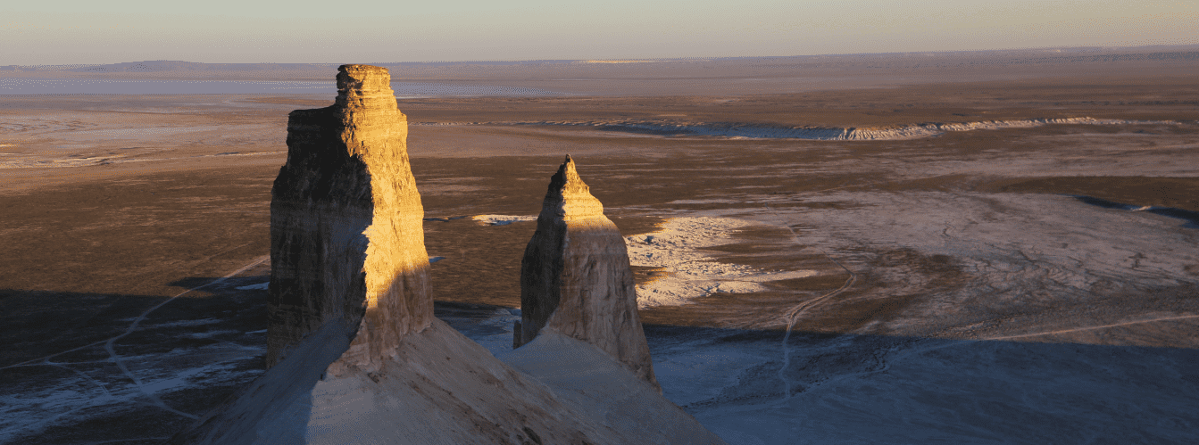
In the geographical framework and expedition logistics of Western Kazakhstan, Mertvy Kultuk holds a key border position: it wraps around the low-lying Buzachi peninsula from the east and northeast and abuts the majestic sheer cliffs (chinks) of the Ustyurt plateau.
The length of the eastern and northeastern sections of the salt flat reaches nearly 100 km, while the northern belt extends almost 80 km from west to east. In terms of tourism, the location is a continuation of northern exploration routes across the region: from here, tracks open toward the narrow, elongated Kaidak bay-salt flat, the Tyub-Karagan peninsula, the Tuzbair salt flat, the Sisem-ata necropolis, the Sam sands, as well as major northern oil fields including Karazhanbas, Kalamkas, and Severnye Buzachi.
--------------------------------------------
How to get there and visit –
The Mertvy Kultuk bay is situated in the northeastern part of the Caspian coast within the territory of the Mangistau region (Beineu district and Mangystau district). The water area and sor expanses curve around the Buzachi peninsula from the southeast and east.
The distance from the city of Aktau to the southern margins of the sor is around 280–300 km, roughly 140–160 km southwest from the district center of the village of Beineu, and about 70–80 km east from the Kalamkas oil field.
GPS geographic coordinates of the Mertvy Kultuk bay:
45°39'21"N 53°14'05"E
The route from the city of Aktau heads north along a paved highway via Akshukur village, Tauchik, and the Karazhanbas and Kalamkas fields (around 280 km of good highway). From the Buzachi industrial roads, the route continues eastward along utility gravel tracks and beaten salt flat ruts (another 50–70 km across rough semi-desert).
A second approach option leads from the village of Beineu: from the Beineu – Aktau highway, turn southwest along dirt roads running below the chinks of Ustyurt (about 140–160 km across challenging steppe terrain). Travel time from Aktau by 4x4 SUV takes roughly 4.5–6 hours.
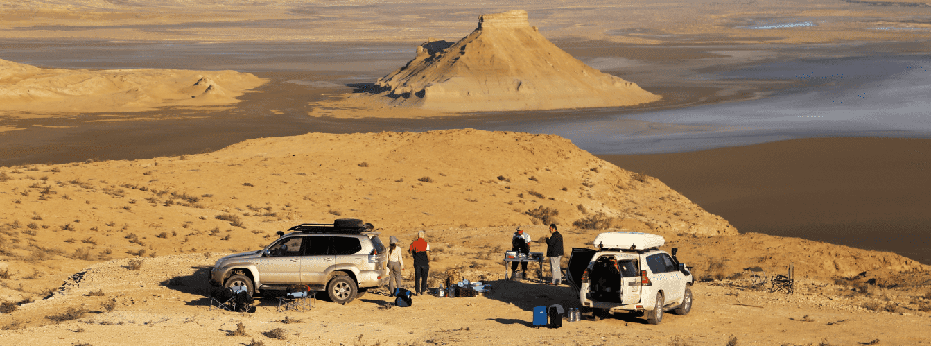
Access tracks and vehicle requirements: an expedition to the Mertvy Kultuk sor falls into the highest category of difficulty in self-sustained overland travel. Travel is permitted EXCLUSIVELY in prepared body-on-frame 4x4 vehicles with ground clearance of 220–250 mm or higher, within an expedition group of at least 2–3 crews for mutual recovery.
The primary mortal hazard of the salt flat is treacherous, sticky clay bogs (takyrs and solonchak quagmires) concealed beneath the dry white salt crust. Attempting to drive onto the surface of the salt flat in a heavy vehicle inevitably causes the car to sink instantly to its axles and frame. Vehicles must be equipped with Mud-Terrain (MT) or reinforced All-Terrain (AT) tires, working winches, farm jacks (hi-lifts), wide jacking bases (sand ladders/recovery tracks), tow straps at least 20–30 m long, and high-output air compressors.
Walking excursions and safety precautions: walking onto the salt flat plain is permissible only on foot after carefully probing the surface with a staff or pole. The thin salt crust frequently conceals deep brine quagmires and washouts. Walking onto the sor barefoot, in sandals, or in fabric footwear is strictly forbidden: concentrated brine instantly burns broken skin from the slightest scratches, and salt crystals have razor-sharp edges. High rubber boots or sturdy leather trekking boots paired with durable gaiters are essential.
ATTENTION: during surge winds from the northwest over the Caspian Sea, seawater surging through the strait can flood dry sections of the sor for dozens of kilometers within a few hours, creating hazardous marshes. The blinding white salt plain creates severe eye strain, requiring sunglasses with high-grade UV protection. Poisonous snakes and arthropods (Halys pit vipers, steppe vipers, scorpions, camel spiders) inhabit the chink slopes, so camping areas require continuous vigilance.
Environmental safety rules: the shore of Mertvy Kultuk is a fragile natural zone with a delicate hydrological balance.
Within the limits of the sor and adjacent chinks, it is STRICTLY MANDATORY TO:
– maintain full self-sufficiency and pack out all household waste (plastic containers, canned tins, technical fluids) to permanent disposal sites;
– avoid cutting random tire ruts across salt flat soils, which damages the delicate microrelief;
– refrain from spilling engine oil, antifreeze, or any automotive fluids onto saline ground;
– eliminate open fires using dried wormwood or saltwort shrubs (cooking is allowed solely on portable gas stoves);
– avoid disturbing nesting grounds of rare birds and flamingo colonies across waterlogged marshes.
Infrastructure: civilization is entirely absent for hundreds of kilometers around the Mertvy Kultuk sor (there are no hotels, shops, settlements, or drinking water sources). Expeditions operate in complete autonomy. Each crew must carry a drinking water supply of at least 5–6 liters per person per day, utility water, extra gasoline or diesel fuel in metal jerrycans (at least 60–80 liters per vehicle), a satellite phone, and an expanded medical first-aid kit.
The nearest permanent fuel stations, tire repair shops, and medical facilities are located in Beineu village (150 km) or at the Kalamkas oil field (about 80 km of industrial infrastructure). Mobile reception is completely absent along the borders of the sor, appearing only near Buzachi oil operations.
Best time to visit is the dry shoulder season: spring (late April through late May) and autumn (September – October). During this period, air temperatures stay within a comfortable +18...+25 °C, and the salt flat dries out thoroughly after winter precipitation. In July and August, extreme desert heat exceeds +42...+45 °C, turning the sor into a sweltering furnace with dense salt vapors. During autumn rains (November) and spring snowmelt (March – early April), the sor becomes completely impassable for any wheeled transport.
--------------------------------------------
History
The history of the Mertvy Kultuk bay is a dramatic chronicle of geographical discoveries in the Caspian basin, diplomatic expeditions of the Russian Empire, and the development of the rich oil and gas horizons of Mangystau.
Having formed on the bed of a relict marine basin of the Tethys Ocean, this bay served for millennia as a natural eastern border for nomadic tribes of Sarmatians, Massagetae, and later the Kazakhs of the Junior Zhuz (the Aday clan) and Nogais.
The first reliable instrumental surveys of the bay were conducted during the Petrine era. Between 1719 and 1727, prominent Russian hydrographer and navigator Fyodor Ivanovich Soymonov carried out the first detailed inventory of the Caspian Sea shores. On maps of that period, the bay was designated the Blue Sea, reflecting the deep color of its open waters during high Caspian transgression levels.
In 1832, a comprehensive description of the bay was completed by the Caspian naturalist and explorer Grigory Silych Karelin. During the imperial era, this strategic body of water was renamed Tsesarevich bay (in honor of the heir to the Russian throne). The presence of island ridges, notably Durnev island, allowed naval officers and researchers to set up observation posts and navigation landmarks.
Following the establishment of Soviet power, the bay's place names mirrored the new ideology: it became known as Komsomolets bay. However, the catastrophic drop in Caspian Sea levels during the 1930s and 1940s (caused by climate cycles and the damming of the Volga) led to severe desiccation of the water mirror. The water receded for dozens of kilometers, depths dropped to a critical 1 meter, and the surface area contracted thirtyfold—from 15,000 sq. km down to a tiny 500 sq. km. It was during this period that the Turkic historical name Mertvy Kultuk (Өлі қолтық, literally "dead bay, blind creek") took hold permanently for the gigantic saline wasteland.
An unexpected resurgence occurred in the late 20th century: beginning in 1978 and lasting through the mid-1990s, the Caspian level rose by more than 2.5 m. Waters once again flooded the dry bed of Komsomolets bay and its southern branch, Kaidak bay, creating extensive marshes and shallow lagoons. A new phase of water retreat in the 2010s and 2020s returned Mertvy Kultuk to its status as a stark salt flat.
Concurrently, the area drew the attention of geologists: within the Buzachi–North Ustyurt trough, rich hydrocarbon-bearing horizons were discovered. In the northern section of the sor, 300 km northeast of Aktau, the promising "Mertvy Kultuk" geological structure was identified, with recoverable reserves estimated at around 164 million tons of oil, where national operator KazMunayTeniz undertook exploration projects across the Sarytau, Salkyn, and Ostrovnaya blocks.
Information
In structural and geomorphological terms, Mertvy Kultuk is a gigantic, gently sloping sor-solonchak depression formed in the downwarp zone of the Paleozoic basement of the Buzachi–North Ustyurt system of troughs. The geological profile of the basin floor consists of Neogene, Akchagylian, and Quaternary sediments of the ancient Tethys Ocean.
The floor of the salt flat is a gently concave plain with absolute elevations ranging from -26 to -28 m below world sea level. Along the eastern rim of the basin, at the base of the Ustyurt plateau chinks at elevations between -25 and -22 m, ancient wave-cut scarps, sandy beach ridges, and clay terraces carved by surf during peak flood stages of the Khvalynian and New Caspian basins are clearly traceable.
The mineralogical composition of the salt flat consists of chloride-sulfate salts of sodium, magnesium, and calcium. The surface features a dense crust of halite and gypsum 2 to 10 cm thick, underlain by a horizon of black and gray hydrotroilite silts carrying a pungent hydrogen sulfide odor, saturated with mineralized brine with a density up to 1.2–1.3 g/cu. cm.
The hydrological regime displays pronounced wind-driven and seasonal characteristics. Under persistent, strong northwesterly onshore winds, Caspian seawater forces through the narrow mouth of the bay, submerging the salt plain beneath 0.5 to 2 m of water and converting it into an impassable mire. Under southeasterly offshore winds, the water retreats rapidly, leaving behind a crystallizing crust of salt.
The "Mertvy Kultuk" oil and gas structure covers an area of 7,273 sq. km. Productive horizons are associated with Jurassic and Triassic terrigenous and carbonate strata at depths ranging from 1,500 to 3,500 m. Estimated geological reserves amount to hundreds of millions of tons of liquid hydrocarbons (with 110 million tons attributed to the Sarytau block).
The climate of the area is extremely arid, sharply continental, and desert-like. Winters are severe and windy, with average January temperatures of -8...-11 °C (dropping to -30 °C during gale-force winds). Summers are sweltering and dry: average July temperatures reach +29...+32 °C, while temperatures on the surface of the salt crust regularly exceed +60 °C. Annual precipitation is sparse, not exceeding 100–120 mm per year.
Detailed site description
The natural salt flat and landscape complex of Mertvy Kultuk comprises the following characteristic elements:
• Hundred-kilometer basin of the Mertvy Kultuk sor – a giant, gently concave salt flat plain blanketed with a crust of snow-white crystalline salt from the Tethys Ocean;
• Kaidak bay-salt flat – a narrow 100-kilometer southern arm of the depression, cutting deeply between the Ustyurt plateau and the Buzachi peninsula;
• Wave-cut scarps and coastal ridges of Ustyurt – ancient marine terraces at elevations from -25 to -22 m, recording historic flood levels of the Caspian;
• Wind-driven marshes of the Komsomolets bay throat – coastal sectors periodically flooded with sea brine, shifting boundaries under the influence of surge and ebb winds;
• Durnev island – a large sand-clay residual island in the northwestern section of the bay's waters, serving as an ornithological refuge;
• Oil and gas cluster of the Sarytau and Salkyn structures – exploratory drilling sites and production horizons of the Buzachi–North Ustyurt trough;
• Hydrotroilite silt muds – sub-salt pliable mineralized layers carrying recognized balneological potential.
Flora and fauna
Plant life of the Mertvy Kultuk sor and adjacent deserts is extremely sparse and adapted to intense soil salinity. The surface of the salt flat is virtually devoid of higher plants, with the exception of microscopic halophilic algae and halobacteria that lend a pinkish tinge to the brine. Extreme halophytes grow along shoreline ridges and sandy transitions: knobby glasswort, common glasswort, Schober's nitrebush, biyurgun (Anabasis salsa), Gmelin's sea lavender, and fleshy saltwort. Giant wildrye, black wormwood, and camelthorn (alhagi) appear across sandy stretches of the chinks.
Wildlife in the coastal zones survives under a total lack of fresh water. The plateau above the sor and the cliff ledges shelter corsac foxes, wolves, jackals, tolai hares, marbled polecats, steppe polecats, and badgers. Among ungulates, herds of saiga antelopes and cautious Ustyurt mountain sheep (mouflons) periodically venture onto the Ustyurt chinks. Tamarisk gerbils, midday gerbils, and lesser pygmy jerboas inhabit burrows along sandy ridges.
Birdlife represents the primary ecological treasure of the region: Mertvy Kultuk bay and Durnev island lie on a vital Eurasian migratory crossroad. When the basin fills with water, the marshes transform into massive bird colonies. Thousands of greater flamingos congregate here, alongside nesting Dalmatian and great white pelicans, great egrets, Pallas's gulls, Caspian terns, and pied avocets. Mute and whooper swans, common shelducks, and greylag geese use the area as a migratory stopover. Birds of prey—including golden eagles, saker falcons, steppe eagles, and long-legged buzzards—nest on the inaccessible ledges of the Ustyurt chinks.
Herpetofauna includes the rapid fringe-toed lizard, desert lidless skink, gray gecko, and tartar sand boa, alongside venomous snakes such as the Halys pit viper and eastern steppe viper.
Legend
An ancient Kazakh legend of the Cursed Caravan and the Sleeping Khan is told about the Mertvy Kultuk bay.
The story goes that when the Blue Sea rolled across the floor of what is now a salt flat, the wealthiest khan of the Buzachi nomadic encampments assembled a caravan of a thousand camels laden with gold, silks, and precious silverware. The khan was noted for boundless pride and cruelty: during a severe drought, he refused to spare water from his skins for poor nomads gathering dew drops on clay takyrs.
As the khan's caravan entered the isthmus between the sea and the Ustyurt chinks, the sky suddenly darkened. From atop the cliffs echoed the voice of a dervish saint, pronouncing a curse on the khan's hardened heart: "May this land become dead, may salt swallow your pride, and may not a single drop of fresh water touch your lips forever!" In that very instant, the sea receded, swirling white salt blizzards rose, and bottomless black bogs opened beneath the caravan's feet.
The entire caravan, along with the khan and his boundless riches, was swallowed into the salt quagmire within moments. When the tempest subsided, only a blinding, dead salt desert remained in place of the rolling bay, which nomads called Mertvy Kultuk ("Өлі қолтық"). Elders believe that during the sweltering midday heat, mirages above the sor summon phantom silhouettes of camel caravans, and anyone who dares disturb the salt flat for easy riches risks being dragged down into the black mire by the ancient spirits of the great Tethys Ocean.
Conclusion
The Mertvy Kultuk bay-salt flat is a monumental testament to the geological forces of Mangystau, where relics of the prehistoric Tethys Ocean unite with the presence of the Caspian Sea and the sheer ramparts of the Ustyurt chinks. The severe grandeur of its salt plains, colonies of pink flamingos, and vast subterranean petroleum reserves make this remote frontier one of the most enigmatic and evocative destinations of the Northern Caspian.
Interesting attractions nearby:
• Kaidak bay-salt flat;
• Buzachi peninsula;
• Chinks of Western Ustyurt;
• Kalamkas oil field;
• Karazhanbas oil field;
• Tuzbair salt flat;
• Sam sands;
• Beineu village;
• Akespe tract;
• Mount Otpan-tau;
• Usak tract;
• Kapamsay canyon;
• City of Aktau;
• Durnev island;
• Donyztau tract.
Sacred and pilgrimage sites on Mangyshlak:
• Masat-Ata underground mosque;
• Kenty-baba necropolis;
• Koben mosque;
• Zholaskan mosque;
• Kolbas Ishan mosque;
• Sonabay underground mosque;
• Uytoly-Ata mosque;
• Bayte sanctuary.
Photogallery: