Monumental limestone ledge of the Zhogargy and Ortasha plateaus –
Mount Ulken-Keme (in Kazakh toponymy – Үлкен кеме, translating as "Big Ship") is a colossal erosional rock massif-ledge that acts as one of the primary panoramic summits and landscape dominants of the Bozzhyra tract. This monumental limestone promontory is located in the Karakiyan district of western Kazakhstan, occupying a strategic position at the junction of the tiered steps of the Zhogarly plateau (Upper plateau) and the Ortasha plateau (Middle plateau), which fall within the conservation zone of the Zhabai-Ushkan state nature sanctuary.
The massif received its evocative name "Big Ship" from its unique geomorphology: the elongated promontory with vertical layered walls juts westward out into the airspace of the tract for 300 meters, resembling a giant ocean liner stranded above the vast plains of an ancient seabed.
The absolute elevation of Mount Ulken-Keme is 240 meters above sea level, making it one of the highest points in this sector of the chink. From the flat summit of the massif opens an expansive 360-degree panorama: deep below lies the floor of the Oynak Bozzhyra tract, while to the south and southeast glisten the snow-white expanses of the Karashek salt flat. To the northwest rise the table-topped Mount Borly-Tau and the conical dome of Mount Shokytau; 2 kilometers to the north, the dome of Mount Yurt and Bozzhyra Canyon (Shatkal) cutting through the limestone are in plain view; and along the southeastern horizon, the serrated dorsal crest of Mount Ushkir-tau stands out distinctly.
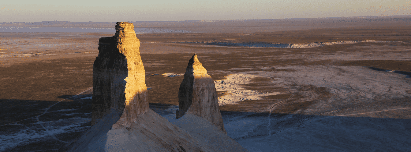
The width of the upper flat surface of the ledge tapers from 126 meters at its base down to a narrow point only 10–12 meters wide at its westernmost prow. At the very tip of the rocky stem, the ledge plunges into an abyss of over 150 meters, and directly at its base rise the two famous vertical chalk bastion peaks – the "Fangs of Bozzhyra".
The summit of Ulken-Keme is recognized as an iconic viewpoint across the entire Mangyshlak Peninsula: this is the exact spot where the most famous bird's-eye panoramic photographs of the Azu-Tisteri rocks are taken.
Excursion to Mount Ulken-Keme in the Bozzhyra tract from the city of Aktau (1 day)
--------------------------------------------
How to get there and visit –
The Ulken-Keme mountain massif is located in the Karakiyan district of the Mangistau Region in the central-southern sector of the Bozzhyra tract. The distance from the city of Aktau is around 285–300 km, roughly 145–155 km from the town of Zhanaozen, directly above the "Fangs of Bozzhyra" (Azu-Tisteri) rocks at the foot of the cliff, about 2.5 km southwest of Mount Borly-Tau, roughly 4.5 km southeast of Mount Shokytau, and 4–5 km north of the Karashek salt flat.
GPS geographic coordinates of the summit of Mount Ulken-Keme:
43°25'25"N 54°04'14"E
Driving route from Aktau: the route heads southeast along the paved highway through Zhanaozen toward the Beket-Ata underground mosque—totaling about 240 km of paved surface. Approximately 20 km before the Oglandy tract, turn south into the open steppe along the well-worn dirt tracks of the upper Ustyurt plateau toward the viewpoints along the chink.
Access to the trailhead for the hike up Ulken-Keme runs along the upper rim via the Ortasha plateau. Entry onto the promontory is made strictly from the northern side across a gentle slope where the vehicle track terminates at an improvised parking area for 4x4 SUVs. Pure driving time from Zhanaozen takes between 3.5 and 4.5 hours.
Walking route and landmarks:
From the vehicle parking area on the Ortasha plateau, a foot trail leads to the westernmost tip of the promontory. The route passes across the gently sloping, rocky surface of the Zhogarly plateau. In places, the path fades into limestone slabs, but navigation remains straightforward due to the elongated shape of the promontory.
The main historical and visual landmark along the path is an ancient stone fortress-shelter (an archaeological structure built from unworked limestone slabs), positioned en route to the tip of the promontory. The one-way walk covers about 1–1.5 km and takes 25 to 40 minutes at an easy pace.
Vehicle requirements: traveling across the upper plateaus of Bozzhyra requires a four-wheel-drive 4x4 SUV with ground clearance of at least 220 mm and durable All-Terrain or Mud-Terrain tires. The upper plateaus consist of hard bedrock and gravel littered with sharp flint chips that threaten tire sidewalls. Navigating with an experienced local guide and in a convoy of at least two equipped vehicles is strongly recommended.
Safety precautions on Mount Ulken-Keme:
Being on the promontory demands strict discipline and maximum caution.
– The vertical drop exceeds 150 meters, and there are no protective barriers or railings.
– Approaching the very brink of the precipice while standing is strictly prohibited: sudden, powerful wind gusts frequently sweep across the summit, capable of knocking an adult off balance.
– To take photographs of the Azu-Tisteri rocks and the panorama of the Oynak Bozzhyra tract safely, drop to your knees or lie flat on your stomach on the solid limestone slab, extending only the camera forward.
– Never step onto fractured or undercut cornices eroded by wind: the limestone can give way under human weight.
– Children must be supervised at all times and kept firmly by the hand at a safe distance from the edge.
– Footwear must be closed, supportive, and fitted with non-slip trekking soles.
Environmental safety rules:
– drive vehicles strictly along established ruts on the Ortasha plateau;
– do not dismantle or damage the ancient stone fortress-shelter;
– do not paint or carve graffiti on the rock slabs of the promontory;
– carry out absolutely all household trash;
– do not light open campfires on the wind-swept plateau.
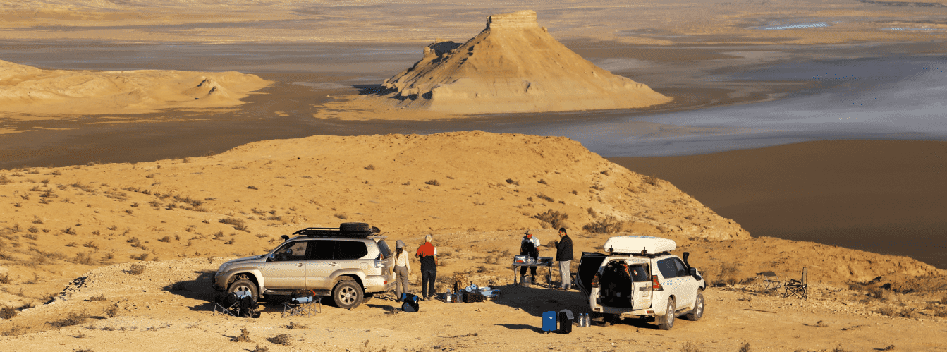
Infrastructure: the area of the Zhogargy plateau and Mount Ulken-Keme is completely wild and autonomous. Permanent accommodations, drinking water sources, filling stations, and cafes are entirely absent. Mobile cellular reception across the open plateau is weak and often disappears near the edge of the cliffs. The drinking water supply must be calculated at a minimum of 5 liters per person per day. Campers pitch tents in low depressions on the plateau well back from the cliff edges to shelter from gale-force winds.
Best time to visit is April, May, September, and October. During these months, temperatures remain comfortable (+18...+25 °C), and horizon visibility is at its clearest. At sunrise and during the hour before sunset, the "Fangs of Bozzhyra" rocks and the white cliffs of Ulken-Keme are illuminated in fiery red and golden tones, providing prime light for photography.
--------------------------------------------
History
The geological record of Mount Ulken-Keme spans tens of millions of years and is directly tied to the regression of the ancient Tethys Ocean and the formation of the tableland relief of the Turan Plate.
During the Paleogene and Upper Cretaceous epochs, the territory of Ustyurt was a deep marine shelf. Hundreds of thousands of generations of calcareous plankton, corals, belemnites, and mollusk shells settled on the seabed, compressing into dense layers of writing chalk, marl, and durable Sarmatian limestones. When tectonic uplift caused the sea to retreat, the plateau was exposed to a harsh continental climate.
The decisive factor in sculpting the elongated promontory of Ulken-Keme was multidirectional vertical and aeolian erosion. Watercourses draining from the Upper Zhogarly plateau carved into a network of deep fractures on either side of the promontory, isolating the rock monolith. Over millions of years of denudation, softer chalk strata were broken down and swept away by winds, while the monolithic limestone headland was left jutting out over the Oynak plain, preserving the original elevation of the ancient plateau surface. The Azu-Tisteri Fangs standing at the base of the promontory are the former continuation of the Ulken-Keme massif, severed from it by erosion.
In historical times, the summit of Ulken-Keme was utilized by the nomads of Mangystau as a natural observation post and defensive redoubt. On the trail leading toward the point of the promontory remain the ruins of a stone fortress-shelter built with dry-laid masonry from massive coquina slabs. During periods of intertribal conflicts and raids, this fortification blocked the narrow neck of the promontory, turning Ulken-Keme into an impregnable natural citadel commanding caravan routes for dozens of miles around.
In Kazakh toponymy, the name "Ulken-Keme" became established among pastoralists of the Aday tribe, who noted the resemblance of the isolated promontory to a giant ship sailing across the stone sea of Bozzhyra.
In the modern era, the Ulken-Keme massif was incorporated into the Zhabai-Ushkan sanctuary covering 316,141 hectares, becoming one of the most recognized natural landmarks of the Republic of Kazakhstan.
Information
Geomorphologically, Mount Ulken-Keme is a bedded-denudational structural rock promontory-ledge of subhorizontal bedding, composed of Sarmatian limestones and Paleogene carbonate strata of the Ustyurt plateau.
Morphometric characteristics of the massif:
– absolute summit elevation: 240 m above sea level;
– westward projection of the promontory: about 300 m out from the main rim of the plateau;
– width of the upper terrace at the base: up to 126 m;
– crest width at the westernmost tip: from 10 to 12 m;
– vertical cliff drop at the prow: over 150 m of sheer fall;
– hypsometric position: structural ledge between the Zhogargy and Ortasha plateaus;
– distance to the "Fangs of Bozzhyra" rocks (Azu-Tisteri): directly below the western precipice of the promontory;
– distance to Mount Borly-Tau: 2.5 km to the southwest;
– distance to Mount Shokytau: 4.5 km to the southeast;
– walking distance from the vehicle drop-off area: 1–1.5 km.
Lithological composition:
The upper protective cap of Mount Ulken-Keme is composed of hard gray and yellowish-pale organogenic-detrital coquina limestones of Paleogene age, exhibiting high mechanical strength. Beneath lie thick beds of light-gray marls and white writing chalk of Upper Cretaceous age, forming sheer, slightly stepped cliff walls. The base of the ledge is littered with coarse rubble talus and collapsed limestone blocks. Situated near the mountain is also the Silicon Valley.
Paleontological complex:
The limestone beds of the summit and the cliff exposures contain fossils from the ancient Tethys Ocean:
– cross-sections and casts of bivalve mollusks and pectinids;
– fossilized belemnite rostra ("devil's fingers");
– tests of Eocene sea urchins;
– teeth of prehistoric Paleogene sharks.
Climatic conditions:
The climate of the region is sharply continental and semi-desert. The summit of the Ulken-Keme promontory is exposed to persistent Ustyurt winds, which frequently exceed speeds of 15–20 m/s along the rim. In summer, daytime air temperatures on the stone slab reach +40...+43 °C, while in winter they drop to -25 °C with severe blizzards.
Detailed site description
The natural landscape complex of Mount Ulken-Keme and adjacent structures of the Bozzhyra tract includes the following key features and panoramic viewpoints:
• Rock promontory-ledge of Ulken-Keme – a monumental limestone massif 240 meters high, projecting 300 meters westward over the abyss of the tract's lower amphitheater.
• Western prow of the Ulken-Keme cliff – a viewpoint tapering down to 10 meters wide at the brink of a 150-meter precipice, offering an overhead vertical perspective onto the Azu-Tisteri rocks.
• "Fangs of Bozzhyra" rocks ("Azu Tisteri") – two legendary pointed limestone bastions roughly 200 meters high, rising directly beneath the western tip of the promontory.
• Ancient stone fortress-shelter – an archaeological landmark on the Ortasha plateau trail, built with dry-laid limestone slabs across the narrow neck of the promontory.
• Ortasha plateau – a broad intermediate limestone terrace of the tract, providing the base terrain for the walking route to the summit of Ulken-Keme.
• Upper Zhogarly-Bozzhyra plateau – the flat tableland of the Western Chink of Ustyurt, providing vehicle access to the Bozzhyra massifs.
• Floor of the Oynak Bozzhyra tract – a vast clay-gravel plain of the lower tier stretching out at the foot of the Ulken-Keme cliffs.
• Mount Borly-Tau butte massif – a table-topped chalk upland with stepped white walls, located 2.5 kilometers to the northeast.
• Conical Mount Shokytau – a symmetrical three-tiered pyramid butte, visible from the promontory 4.5 kilometers to the northwest.
• Serrated crest of Mount Ushkir-tau – a wall-like rock massif on the horizon to the southeast, reminiscent of the spine of a prehistoric reptile.
• Salt depression of Sor Karashek – an extensive endorheic basin with a white salt crust, stretching south from the foot of the massif.
• Fourth Panorama of the chink (Martian) – an adjacent elevated viewpoint of the chink, showing the Ulken-Keme promontory in full profile.
Flora and fauna
Vegetation across the stony summit of Mount Ulken-Keme is very sparse due to gale-force winds and the absence of a developed topsoil layer. Clinging to the limestone slabs of the Zhogargy and Ortasha plateaus are occasional low shrubs of boyalych, Anabasis salsa (biyurgun), gray wormwood, and winterfat. In small karst fissures in spring, wild ephemerals bloom briefly: miniature Sogdian tulips, hornhead, and desert feather grass.
Wildlife is adapted to vertical elevation drops and the rocky refuges of the chink. The sheer cliff walls of Mount Ulken-Keme provide a habitat for the Ustyurt mountain sheep (mouflon / argali), listed in the Red Book of Kazakhstan. Flocks of argali navigate narrow ledges along the vertical 150-meter walls beneath the promontory, where they remain out of reach of terrestrial predators.
Rare raptors nest in the fissures of the cliffs: the saker falcon, golden eagle, Egyptian vulture, and kestrel. Desert ravens, black swifts, rock doves, and wheatears are permanent residents around the summit rocks.
Terrestrial mammals traversing the plateau include corsac foxes, wolves, tolai hares, and badgers. Colonies of gerbils and jerboas inhabit the boulder screes around the ancient stone fortress.
Reptiles are represented by the rapid fringe-toed lizard, steppe agama, Caspian gecko, and Steppe ribbon racer. On hot days, camel spiders (solifuges) and scorpions hide within the crevices between slabs.
Legend
An ancient Mangystau legend of the Stone Ark of the Batyrs is told of Mount Ulken-Keme.
The tale recounts that during the great nomadic wars across the Ustyurt Plateau, a massive invading horde attacked peaceful settlements. The odds were unequal, and the clan elders charged the young batyrs with saving the elderly, women, and children by guiding them to the most inaccessible promontory on the chink.
Across the narrow neck of the cliff, the batyrs raised an impenetrable wall of white stone, closing off the only approach. The enemy encircled the promontory on all sides, yet could not breach the stone rampart or scale the sheer 150-meter cliffs. The siege dragged on for weeks, and when the last water stores were depleted, the people turned to the heavens in prayer to save their lineage.
At that moment, thunder shook the earth, a thick mist from the ancient retreated sea enveloped the land, and the ancestral spirits turned the entire rocky promontory into a titanic stone ship—Ulken-Keme—sailing above the mortal world. Terrified by the wrath of the spirits, the invaders fled, while the defenders descended from the heights, preserving their people. Nomads of the Aday tribe believed that the stone ship of Ulken-Keme remains on eternal watch over the tract, granting fortitude, clarity of vision, and protection to all who stand upon its prow with a pure soul.
Conclusion
Mount Ulken-Keme is one of the most magnificent viewpoints of the Bozzhyra tract and the Western Chink of Ustyurt. The combination of a 150-meter cliff drop, an overhead angle onto the "Fangs of Bozzhyra", an ancient stone fortification, and vast plateau horizons makes this summit a standout destination of any expedition across the Mangistau Region.
Nearby attractions:
• "Fangs of Bozzhyra" rocks ("Azu Tisteri");
• Upper Zhogarly-Bozzhyra plateau;
• Floor of the Oynak Bozzhyra tract;
• Fourth Panorama of the chink (Martian);
• Third Panorama of the Bozzhyra tract;
• Second Panorama of the Bozzhyra tract;
• First Panorama of the Bozzhyra tract;
• Fifth Panorama of the Bozzhyra tract;
• Mount Borly-Tau butte massif;
• Mount Shokytau butte;
• Chalk Mount Yurt;
• Serrated crest of Mount Ushkir-tau;
• Bozzhyra Canyon (Shatkal Gorge);
• Karashek salt flat and sor;
• Silicon Valley of the Bozzhyra tract;
• Kyzylkup tract (Tiramisu);
• Mount Bokty butte;
• Beket-Ata Underground Mosque (Oglandy);
• Town of Zhanaozen;
• City of Aktau;
• Ortasha plateau;
• Zhabaiushkan State Nature Sanctuary;
• Zhosaly descent from the Western Chink of Ustyurt;
• Ancient stone fortress-shelter on the Ulken-Keme promontory.
Photogallery: