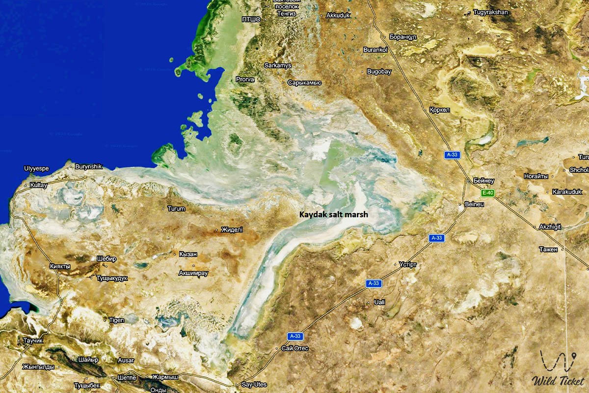
Dazzling salt expanses and relict depression of the Northern Caspian –
Kaydak Bay (Kaz. Qaidaq shyghanaghy) represents a colossal narrow and shallow sor-bay in the northeastern part of the Caspian Sea, indenting deeply into the continental plains of western Kazakhstan. This unique hydrological feature separates the clay-sand deserts of the Buzachi Peninsula from the precipitous limestone chinks of the Ustyurt Plateau in the Mangystau region.
Stretching for dozens of kilometers from north to south, the bay's water area and fringing salt marshes occupy vast tectonic depressions of the Mangystau district, merging at its northern mouth with the immense Dead Kultuk Bay (formerly Tsesarevich Bay).
In the tourism and expedition geography of Northern Mangystau, Kaydak Bay stands as one of the most remote, wild, and mesmerizing off-road frontiers. The journey to these salt expanses begins from the regional center Aktau, from where paved highways lead northeast through the steppe hubs of Shetpe and Zhetybay. From the west, the lowland plains of the oil-rich Buzachi Peninsula with the Oliktykol salt marsh approach the depression, while to the south and southwest open breathtaking panoramas of the mountain ridges of Northern Aktau, the ancient Koshkar-Ata necropolis, and the Torysh Valley of Spherical Concretions.
The landscape and geological character of the bay were formed by continuous long-term fluctuations of the Caspian Sea and the legacy of the retreating ancient Tethys Ocean. From the southern end of Kaydak Bay, expedition convoys chart a course east toward the renowned chalk salt flat of Tuzbair, the dizzying chinks of Manata Pass where the celebrated Man-Ata mausoleum stands, the stepped scarps of the Bozzhira tract, the banded Mount Bokty, and the otherworldly landscapes of the Karynzharyk depression.
The hydrological regime of the bay is entirely governed by long-term transgressions and regressions of the sea, as well as powerful wind-driven surges and recessions. During periods of falling water levels, the bay's surface dries out, exposing a dazzling white, crunchy crust of self-precipitated salt.
Under northerly surge winds, the basin is once again inundated by a shallow film of turquoise brine, becoming a sanctuary for thousands of greater flamingos and migratory waders. From these salt frontiers, well-worn ruts lead south and east along the plateau chinks, offering 4x4 expedition vehicles a direct approach to the strictly protected lands and relict landscapes of the Ustyurt Nature Reserve.
Today, Kaydak Bay is recognized as one of the most surreal and severe natural phenomena in Eurasia, attracting experienced expedition teams, photographers, and geologists with the cosmic scale of its salt wastelands, sheer plateau chinks, and absolute primeval silence.
From here through the village of Shetpe, one can travel toward the Karagiye depression to Lake Karakol. Another route through the city of Zhanaozen leads to the Basgurly – Zhazgurly depression system and the Kenderli salt flat.
--------------------------------------------
How to get there and visit –
Kaydak Bay is situated in the northeastern part of the Mangystau region along the border with the Atyrau region, stretching along the eastern base of the Buzachi Peninsula and the western chink of the Ustyurt Plateau. The distance from the city of Aktau to the central section of the bay is roughly 220–260 km depending on the chosen route, from the village of Shetpe – around 120–140 km, and from Tauchik village – about 110–130 km.
GPS geographical coordinates of Kaydak Bay:
45°05'12"N 53°35'20"E
The primary driving route from the city of Aktau leads northeast along the paved highway of republican significance Aktau – Shetpe – Beyneu. Before reaching the district center of Shetpe, near Zhetybay village or Shetpe station, expeditions turn north toward the village of Tushchyqudyq and the oilfields of the Buzachi Peninsula (Kalamkas, Karazhanbas), from where industrial graders and steppe dirt tracks lead to the western shore of the bay.
The second and most scenic route runs to the eastern rim of the bay along the crest of the western chink of Ustyurt, offering breathtaking panoramic vistas across the salt-flat basin from heights of over 150–200 meters.
Visiting Kaydak Bay strictly requires a purpose-built 4x4 expedition vehicle with high ground clearance, heavy-duty suspension, reliable mud-terrain or all-terrain tires, a winch, a high-lift jack, sand ladders, and reserve fuel.
Driving onto the surface of the salt flat in any vehicle is STRICTLY PROHIBITED: beneath the deceptively dry white salt crust only a few centimeters thick lies deep, viscous, and corrosive salt mud (sor) that immediately bogs vehicles down to the axles.
Visiting regime: the shores and chinks of the bay are open to visitors, though travel involves extreme self-reliance. Due to proximity to state borders and restricted oilfield facilities, all expedition members must carry original passports or ID cards.
Infrastructure in the Kaydak Bay area is completely non-existent for hundreds of square kilometers around: there are no settlements, freshwater springs, gas stations, or cellular coverage. The nearest outposts of civilization with fueling stations, tire shops, and stores are in Shetpe, Sayotes, and Tushchyqudyq.
Every expedition must be entirely self-contained: carry a potable water supply of at least 7–8 liters per person per day, technical water for washing salt off equipment, heavy-duty expedition tents with storm guy-lines, and a satellite phone or satellite tracker.
The best time to visit is during the dry shoulder seasons: late spring (May) and early autumn (September – October). During these periods, the exhausting heat subsides, the air is crisp, and dirt tracks on the plateau remain dry and firm. In summer (June – August), temperatures in the salt basin soar above +42...+45 °C, transforming the depression into a searing salt pan with intense evaporation. In early spring and late autumn, rains and wind-driven water surges render approaches impassable.
--------------------------------------------
History
The history of Kaydak Bay is a dramatic chronicle of the long-term transformations of the Caspian Sea, where water and dry land have waged an endless contest for territory across centuries. The bay's name originates from the Turkic word "qaidaq" (associated in the local Mangystau dialect with notions of a "blind arm", "narrow strait", "cove", or "drying bed"), perfectly characterizing the form of this long and narrow natural depression.
During the Middle Ages and the peak of the Nogai Horde, the eastern shores of Kaydak and the crags of Ustyurt served as a natural barrier for nomads: bypassing the bay to the north was impossible due to the mudflats of Dead Kultuk, so caravan trails from Khiva and Urgench to Lower Volga cities ran along the upper plateaus flanking the sheer chinks.
In the first half of the 19th century, the bay drew the close attention of the Russian Empire. In 1834, on instructions from Orenburg Military Governor V.A. Perovsky, prominent explorer G.S. Karelin founded Novo-Alexandrovskoye Fort at the entrance to Kaydak Bay (within Dead Kultuk Bay). The fortress was intended to protect Kazakh clans of the Junior Zhuz from Khivan incursions and to control maritime routes. However, due to continuous shallowing of the Caspian, the severe salt-flat climate, and the absence of fresh water, the fort was decommissioned in 1846 and relocated to western Tupkaragan (becoming the future Fort-Shevchenko).
Throughout the second half of the 19th century and the Soviet era, Kaydak Bay repeatedly underwent periods of total desiccation. During the catastrophic drop in Caspian Sea levels between the 1930s and 1970s, the bay turned into a completely dry sor across which salt dust storms raged. Yet from the late 1970s to 1995, when the sea level surged by more than two meters, Kaydak filled with seawater once more, re-emerging as a shallow marine gulf teeming with life.
Today, amid a new regressive cycle of the Caspian, Kaydak Bay is once again reverting to a gigantic salt flat, remaining an essential natural testing ground for observing global climatic cycles.
Information
Morphometrically, Kaydak Bay represents a narrow, strongly elongated liman-lagoon depression. The length of the bay from north to south spans roughly 100–120 kilometers with a width ranging between 2 and 15 kilometers. The floor of the bay lies well below global sea level (from -26 to -29 meters), while the western chink of Ustyurt towering over its eastern flank soars to absolute elevations of +120 to +180 meters, creating a grandiose vertical drop of sheer stepped cliffs.
The geological structure of the basin is composed of thick Paleogene and Neogene sedimentary strata from the ancient Tethys Ocean. The bottom is underlain by fine-grained saline silts (khaka), gypsum, and thick beds of self-precipitated halite salt alternating with gray clay layers. The chinks of Ustyurt plunging toward the bay reveal multicolored beds: bright-white Sarmatian limestones, yellowish marls, variegated Paleogene clays, and gypsum druses.
The hydrological regime displays a distinct pulsating character. The bay has no permanent river runoff and is fed solely by storm-surge waters from Dead Kultuk during northerly and northwesterly winds ("moryanas"), along with seasonal meltwaters descending from Ustyurt's chinks through deep dry ravines (says). Water depth during periods of flooding varies from several tens of centimeters to 1–1.5 meters, while brine salinity reaches extreme levels exceeding 150–200 parts per thousand, turning the bay into a hypersaline water body.
Soil cover around the basin is poorly developed, consisting of automorphic and hydromorphic sor-type solonchaks, puffy salt flats, and crustal-puffy soils with salt efflorescence.
The climate of the area is extremely continental, sharply arid desert. Summers are blistering and dry: average daytime July temperatures range between +34 and +38 °C, with regular extremes exceeding +45 °C over the salt surface. Winters are severe, snowless, and windy, with average January temperatures of -8...-12 °C and frost down to -30 °C during gale-force winds. Mean annual precipitation is negligible at no more than 100–120 mm, while evaporation outstrips rainfall by 10 to 12 times.
Detailed description of the venue
The spatial-natural complex of Kaydak Bay encompasses the following primary landscape zones, morphological features, and scenic viewpoints:
• Western chink of the Ustyurt Plateau over Kaydak – a cyclopean wall of white and cream-colored limestones rising up to 150–180 meters high with weathered promontories, outlier towers, and natural scenic platforms.
• Salt-flat bed of the bay (white sor) – a multi-kilometer, perfectly flat mirror of salt and gypsum crystals shifting in color from dazzling white at midday to delicate pink at sunset.
• Junction mouth with Dead Kultuk Bay – the northern widened sector of the depression where seasonal shallow straits and extensive mud marshes form.
• Says and canyons of the eastern flank – deep erosional gorges cutting into the Ustyurt chink (such as Ashchiayryk and Kindykty says), along which seasonal flash floods carry clay toward the salt flat.
• Buzachi coastal sand mounds – the gentle western flank of the bay where the salt basin transitions smoothly into semi-stabilized sands and saline clays of Buzachi.
• Hypersaline brine pools and micro-lakes – inner remnant enclosed lenses of hypersaline water with turquoise and lilac hues and crystalline crusts on the bottom.
Flora and fauna
The plant life of the Kaydak Bay basin is exceptionally sparse and adapted to extreme soil salinity. Higher vascular plants are absent directly upon the salt crust of the sor. Specialized halophytes grow along the coastal margins and alluvial fans of ravines: European glasswort, Halocnemum strobilaceum, Caspian saltwort, Suaeda, and Gmelin's sea lavender. Sparse communities of white wormwood, Anabasis salsa (biyurgun), boyalych, jointed anabasis, and shrubby Krascheninnikovia (teresken) occur along the chink slopes and adjacent plateau plains. In spring, wild Sogdian tulips and small desert ephemerals appear briefly across the chink shelves.
The fauna, despite harsh conditions, includes rare endemic and protected species. A stable population of the Ustyurt mountain sheep (mouflon), listed in the Red Book of Kazakhstan, inhabits the steep rocky ledges of the western Ustyurt chink. Fleet-footed goitered gazelles and saiga antelopes of the Buzachi and Ustyurt populations roam the flat clay plains along the margins.
Among predatory mammals, wolves, corsac foxes, sand cats, steppe polecats, and badgers den in rock crevices and adjacent ravines. The caracal, a rare relict feline, also inhabits the area.
The avifauna of the bay revives during spring and autumn migrations. The shallows and brine pools of Kaydak serve as a critical staging post for hundreds of thousands of migratory waterbirds. Flocks of greater flamingos, Dalmatian and great white pelicans, mute swans, common shelducks, pied avocets, and black-winged stilts halt here to feed and rest. Raptors nest upon the inaccessible shelves of the chinks: golden eagles, steppe eagles, long-legged buzzards, saker falcons, and Eurasian eagle-owls.
Herpetofauna is represented by the rapid fringe-toed lizard, toad-headed agama, Caspian gecko, sand boa, and arrow snake. Solifuges, tarantulas, and scorpions are active on warm stones at night.
Legend
An ancient Ustyurt legend tells of the White Caravan and the Salt Sovereign in connection with Kaydak Bay.
Tradition recounts that in ancient times, the azure waters of a sacred marine strait lapped where this lifeless salt marsh now lies, while along its shores grazed rich nomadic clans possessing prized horse herds and countless flocks of snow-white sheep.
One day, the caravan of a powerful and ruthless bai descended through the chinks of Ustyurt to the strait, his camels laden with gold, silver, and precious fabrics. The bai ordered his servants to water the camels from a clear freshwater spring by the sea, but when an impoverished widow with a child dying of thirst approached the water, the bai shoved her aside with contempt and ordered the remaining water poured into the sand, boasting that his camels were worth more than the lives of a hundred paupers.
The exhausted woman raised her hands to heaven and called upon the spirits of the great chinks and the master of the ancient Caspian as witnesses. At that moment the earth trembled, massive boulders crashed down from the plateau, and the waters of the sea retreated northward with a deafening roar. The sun blazed with unbearable fury, and all moisture evaporated before their eyes into blindingly white, toxic salt ash.
The cruel bai and his entire caravan became trapped in the rising salt mire, turning into white salt pillars. Ever since, Kazakhs have named this treacherous and daunting depression Kaydak, believing that in the midday heat haze above the sor, the phantoms of the caravan still wander, reminding all travelers of the retribution visited upon arrogance and cruelty.
Conclusion
Kaydak Bay is a grandiose natural monument and cosmic landscape of Mangystau, where the majesty of sheer Ustyurt chinks converges with the infinite whiteness of untouched salt sors. An expedition to the shores of Kaydak offers travelers a rare chance to encounter the truly wild nature of our planet, feel awe before the scale of the ancient Caspian, and carry away in their hearts the ringing silence of the boundless Asian desert.
Interesting sights nearby:
• Cape Tyub-Karagan;
• Oasis and Khanga-Baba Tract;
• Tamshaly Rocky Gorge;
• Saura Rocky Canyon;
• Tuzbair Chalk Salt Flat;
• Aktau-Buzachi Nature Sanctuary;
• Torysh Valley of Stone Balls;
• Mount Sherkala Outlier;
• Paleontological Guide at Mount Sherkala;
• Medieval Kyzylkala Settlement;
• Canyon of the Bozzhira Tract;
• Oliktykol Tract and Salt Marsh on Buzachi;
• Ashchiayryk Rocky Tract.
Pilgrimage sites:
• Beket-Ata Underground Mosque in the Oglandy Tract;
• Shopan-Ata Underground Mosque in the Karakiyan District;
• Karaman-Ata Underground Mosque and Necropolis;
• Mausoleum of Saint Man-Ata on the Manata Pass;
• Shakpak-Ata Rock-Cut Cruciform Mosque;
• Sultan-Epe Underground Mosque and Necropolis.
Photogallery: