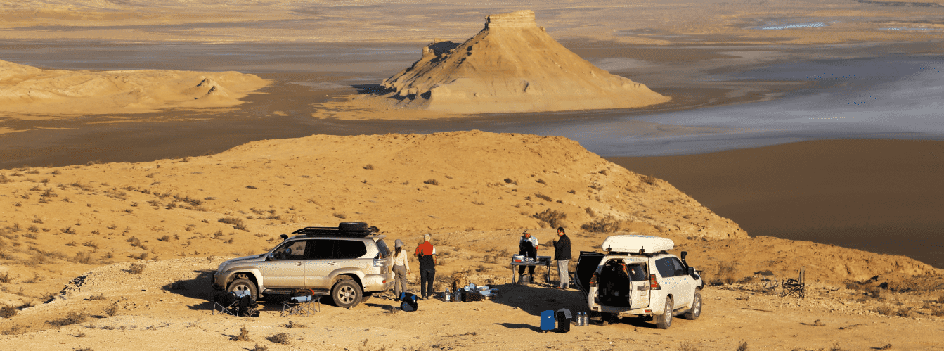
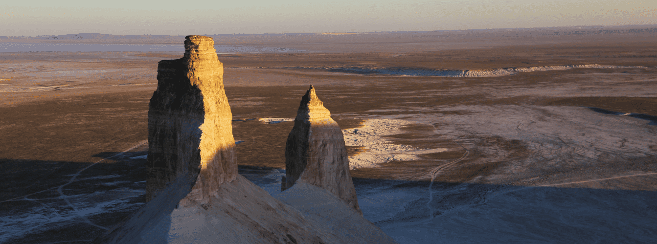
Off-road expedition to the southern sector of the Western chink is a route to the fifth panoramic point of the Bozzhyra tract, opening a panorama over the southern flank of the chalk depression. Unlike previous observation platforms (first, second, third, fourth), here the scarp of the chink steps lower toward the floor of the canyon, bringing travelers into immediate proximity with the pointed residual buttes of Ushkirtau and the bed of the desiccated prehistoric Tethys Ocean.
The fifth panorama of Bozzhyra no. 5 is located at an absolute elevation of 215.3 meters above sea level on the Western chink of the Ustyurt plateau in the Karakiyan district of the Mangistau region. The platform is situated above the western part of the Oynak clearing, just 770 meters northeast of the peaks of mount Ushkirtau and 3 kilometers southeast of the Borly-Tau massif. The distance along the steppe track from the fourth panorama of Bozzhyra to the fifth is only 2.5 kilometers.
From an altitude of 215 meters, an entirely different scale of the tract is revealed: due to the lower elevation drop, the limestone bluffs loom in monumental volume. The sharp chalk pinnacles of the Ushkirtau buttes ("Pointed Mountains") and the white surface of the saline Oynak clearing are clearly visible, while the silhouettes of mount Yurt and the Ortasha plateau stand out distinctly along the horizon. Paleontological relics are frequently discovered within the limestone exposures along the rim of the chink here, including fossilized fragments of colonial corals, brachiopod shells, and prehistoric shark teeth deposited on the ocean floor millions of years ago.
The historical appeal of the location is accentuated by two well-preserved hunting arans situated adjacent to the panoramic platform. Ancient nomads utilized the natural geometry of the headland to drive herds of wild saiga antelopes and goitered gazelles, constructing long stone guiding walls from flagstones that terminate abruptly above the drop-off.
An off-road journey in expedition 4x4 vehicles along the crests of the chink offers a comprehensive perspective on all facets of the Mangyshlak peninsula terrain within a single self-sufficient program. You can explore the detailed 5-day jeep tour itinerary across Mangystau.
List of panoramic viewpoints in the Bozzhyra tract:
• First panorama of Bozzhyra (no. 1);
• Second panorama of Bozzhyra (no. 2);
• Third panorama of Bozzhyra (no. 3);
• Fourth panorama of Bozzhyra (no. 4);
• Sixth panorama of Bozzhyra (no. 6).
--------------------------------------------
How to get there and visit –
The fifth panoramic point of the Bozzhyra tract is located at an altitude of 215.3 meters above sea level on the Western chink of the Ustyurt plateau in the Karakiyan district of the Mangistau region, Republic of Kazakhstan. The distance from the regional center of the city of Aktau is about 298 kilometers, roughly 150 kilometers from the town of Zhanaozen, and about 115 kilometers across paved and well-beaten dirt roads from the last settlement before entering the tract, Senek village.
GPS geographic coordinates of the fifth panorama of Bozzhyra no. 5:
43°24'27"N 54°06'07"E
Key landmarks: the buttes of mount Ushkirtau 770 meters to the southwest, the Borly-Tau massif 3 km to the northwest, the western sector of the Oynak clearing directly below the scarp, and two ancient stone arans on the plateau.
The turnoff from the Zhanaozen – Beket-Ata underground mosque highway begins at the 79th kilometer. The total distance along dirt tracks from the asphalt road to the fifth panorama is 13 kilometers. The transfer from the fourth panorama takes approximately 10–15 minutes (2.5 km along the rim of the chink).
Access and logistics: the route is suitable for four-wheel-drive 4x4 vehicles. The ground consists of clay and crushed rock; in dry periods, the track is firm and well-traveled. Following extended rains, the clay turns slick and makes driving hazardous. Vehicles park on the level, stony plateau, with only a short walk required to reach the viewing edge.
Seasonality and self-sufficiency: the optimal period to visit is from mid-April through June, as well as September and October, before or after the intense desert summer heat. There are no permanent facilities near the tract, so visits are conducted as fully self-contained expeditions.
IMPORTANT: the drop-off height exceeds 100 meters. The limestone layers along the ledge are undermined by wind erosion and contain fissures. Maintain a safe distance from the open brink of the cliff and avoid stepping onto the ancient stone masonry of the hunting corrals.
--------------------------------------------
Photography specifics and site tips:
• Angle on the Ushkirtau buttes: the distance to the pointed peaks of Ushkirtau is minimal from the fifth panorama (only 770 m). A 70–200 mm telephoto lens is ideal for striking close-up shots highlighting the detailed chalk facets and erosion channels;
• Capturing ancient arans: the stone guiding walls of the aran set against the deep drop of the Oynak clearing create a compelling foreground. Use a 20–28 mm wide-angle lens in the morning hours to frame the stonework alongside the open horizon;
• Sunset lighting: evening sun from the west illuminates the eastern flanks of the Ushkirtau buttes, casting soft peach and golden hues over the pale sediments of the Oynak clearing;
• Drone flights: the proximity to the Ushkirtau peaks provides excellent angles for mid-altitude aerial circuits around the buttes. Monitor radio signal reliability when lowering the drone below the rim of the chink, and shield rotor components from fine limestone dust during landing;
• Safety and equipment: mobile reception is entirely absent. Sturdy boots with non-slip soles are essential to protect feet against sharp flint flakes and fossil fragments, alongside UV-protective sunglasses and a drinking water supply of at least 4–5 liters per person per day.
Tours and expeditions to the fifth panorama: visits to the fifth panorama are part of our self-sustained expeditionary 4x4 jeep tours across Mangystau departing from Aktau. We provide fully equipped 4x4 vehicles, professional guides, high-grade camping equipment, field catering, and the option to combine all scenic viewpoints of the chink with the sacred site of Beket-Ata.
Nearby attractions:
• Buttes of mount Ushkirtau;
• Oynak-Bozzhyra clearing;
• Mount Borly-Tau;
• Fourth panorama of Bozzhyra;
• Mount Yurt (253.3 m);
• Fangs of Bozzhyra (Azu tisteri);
• Two ancient hunting arans.
Photogallery: