Tectonic cradle of Southern Mangyshlak and protected sanctuary of wild fauna –
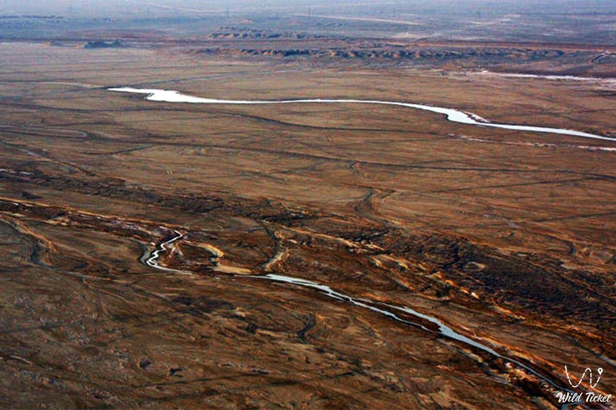
The Basgurly Depression (Kaz. Basgurly oiysy) represents a deep endorheic tectonic-erosional depression, an ancient enclosed karst-suffosion basin, and an outstanding geomorphological natural monument located in the Karakiyan district, Republic of Kazakhstan. The depression forms part of the twin Basgurly – Zhazgurly basin system on the Kenderli-Kayasan Plateau, carving deeply into the dense limestone shield of the upland and creating a stark contrast between the flat semi-desert plain and a sheer rocky amphitheater.
This entire rugged depression is a direct geological legacy of the ancient Tethys Ocean: receding relict marine waters left behind alternating strata of Sarmatian coquina limestones, gypsum, marls, and clays. Under the influence of age-old deep faulting, karst collapses, and wind deflation, an enclosed basin formed with absolute floor elevations plunging below global sea level (down to -6...-40 meters across salt-marsh sectors). The Basgurly depression forms the core of the Kenderli-Kayasan State Nature Sanctuary and serves as a natural western outpost en route to the gigantic Karynzharyk depression, the Kenderli salt flat, and the chinks of the Ustyurt Reserve.
The primary natural value of Basgurly lies in its role as a protective wilderness shelter for rare desert wildlife of Eurasia and Mangystau. High, stratified chinks protect the floor of the basin from gale-force winds, generating an isolated microclimate. Reliable shelter is found here by populations of the graceful goitered gazelle, Ustyurt mountain sheep (mouflon / urial), while the adjacent clay-gravel aprons host nesting grounds of the Red Book-listed MacQueen's bustard (houbara bustard, or zhek). In crevices and grottoes of sheer precipices, rare raptors build nests – the saker falcon, peregrine falcon, Egyptian vulture, and eagle-owl.
The tract derives its Kazakh name from ancient Turkic geographical roots: "bas" signifies head, source, or primary section, while "gurly / qyrly" denotes terraced, precipitous scarps and deep ravines etched into the rock massif of the Mangyshlak Peninsula plateau.
Today, the Basgurly depression is recognized as a benchmark natural area for scientific expeditions, geomorphologists, ornithologists, and self-contained off-road travelers, drawing visitors with the austere primeval silence and dramatic aesthetics of the ancient land of Mangystau.
--------------------------------------------
How to get there and visit –
The Basgurly depression is situated in the southern part of the Karakiyan district of the Mangystau region, on the Kenderli-Kayasan Plateau, roughly 20–25 km east of the endorheic Kuandy depression, south of the Zhazgurly depression, about 70–80 km southeast of the city of Zhanaozen, 72 km west of the Karynzharyk depression, and 220–240 km southeast of the regional center Aktau. An off-road drive from Aktau takes about 4–5 hours.
GPS geographical coordinates of the central part of the Basgurly depression:
42°44'31"N 53°27'30"E
The primary driving route from Aktau leads southeast along the paved highway of republican significance through the Karagiye depression to the city of Zhanaozen (about 150 km). From there, proceed south on asphalt toward the settlement of Senek (about 60 km) or through the settlement of Bostan toward the coast of Kazakh Bay and the village of Kulandy. Leaving the paved highway, the route turns deep into the plateau along compacted gravelly steppe graded tracks and rocky-clay ruts that skirt the Kauyndy and Zhazgurly depressions toward the chinks of Basgurly.
An expedition into the Basgurly depression demands serious off-road preparation: travel is feasible exclusively in body-on-frame four-wheel-drive vehicles (4x4) with high ground clearance, heavy-duty suspension, reliable all-terrain tires (AT/MT), and within a convoy of at least two crews. Sharp limestone scree on the plateau rims poses a significant puncture risk; carrying an air compressor, tire repair kit, and at least two spare wheels per vehicle is mandatory.
During rainfall, the floor of the depression and clay access tracks quickly soften into thick, sticky mud. Descending with wheeled vehicles directly to the bottom of the basin is feasible only along a few old pastoral drag tracks and requires extreme caution.
The territory falls within the protected zone of the Kenderli-Kayasan Nature Sanctuary and is patrolled by conservation agency inspectors ("Okhotzooprom"). Driving off established tracks onto virgin soil is strictly prohibited to avoid destroying fragile ground cover and disturbing nesting MacQueen's bustards. Due to the proximity of the border strip, each traveler must carry an original identity card or passport.
Infrastructure in the tract's vicinity is entirely absent: cellular reception vanishes dozens of kilometers before reaching the destination. The nearest gas stations, shops, tire repair workshops, and hospitals are in the city of Zhanaozen, with small local supply posts in the villages of Senek and Kulandy. Every vehicle crew must carry an autonomous drinking water supply (at least 5 liters per person per day), extra fuel in jerrycans, navigation instruments with pre-loaded satellite maps, and a satellite phone.
The best time to visit is spring (from mid-April to late May), when the surrounding semi-desert turns green and air temperatures remain at a comfortable level (+20...+25 °C), along with early autumn (September – October). In July and August, exhausting heat exceeding +42...+45 °C settles within the enclosed basin, accompanied by dry sand and dust storms.
--------------------------------------------
History
The history of the Basgurly depression dates back to the Cenozoic era, when tectonic rifting of the ancient marine platform initiated the formation of negative structural relief features across Southern Mangyshlak. Over hundreds of thousands of years, processes of karst leaching of salts and limestones combined with intense aeolian deflation excavated the depression, turning it into an isolated wilderness basin amidst a monotonous upland.
In antiquity, the Basgurly basin served as a natural trap and shelter for wild ungulates. Archaeological investigations across the Mangyshlak plateau have uncovered flint flakes, scrapers, and arrowheads from Neolithic and Bronze Age campsites along the rims of the depression. Ancient hunters set up ambushes on the upper terraces of the chink, intercepting herds of saigas and argali descending to temporary water holes on the basin floor.
During the Middle Ages, caravan branches of the Silk Road connecting Caspian Sea ports with cities of Khwarazm crossed the heights of Kenderli-Kayasan. Merchant caravans skirted the steep precipices of Basgurly from above, relying on scarce wells dug along tectonic fault fractures.
For Kazakh nomads of the Aday clan throughout the 18th to 20th centuries, the Basgurly depression served as a valued tract for seasonal wintering grounds (kystau). Sheer rocky walls rising up to a hundred meters reliably protected flocks of sheep and herds of camels from freezing northerly winds and blizzards raging across the open plateau.
The modern phase of studying the depression began in the mid-20th century during comprehensive geological, geographic, and hydrogeological expeditions conducted by the Academy of Sciences of the Kazakh SSR. In 2001, the Basgurly depression was officially incorporated into the Kenderli-Kayasan Nature Sanctuary of republican significance, becoming an international field site for monitoring rare birds and mammals.
Information
The Basgurly depression represents a deep, enclosed tectonic-erosional depression of elliptical form, aligned in an east-west orientation within a unified system alongside the neighboring Zhazgurly basin. The depression extends for over 10–12 kilometers with a width ranging from 4 to 7 kilometers. The vertical relief amplitude between the plateau surface (elevations of +120...+160 meters above sea level) and the depression floor reaches 100–150 meters, with several sectors of the floor dropping below global sea level.
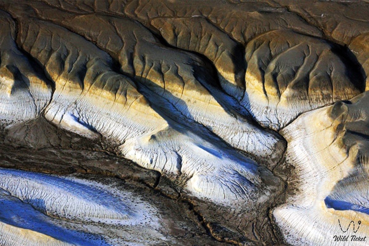
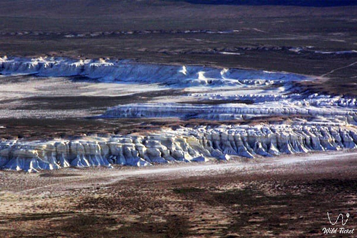
The geological basement exposes a thick complex of Meso-Cenozoic marine sediments. The flanks of the basin are composed of horizontally bedded strata of dense Sarmatian coquina limestones, oolitic carbonates, bedded marls, gypsum, and sandstones of Paleogene and Neogene age. The lower tier of the scarps and the floor consist of impermeable variegated clays. Marine fossils of the ancient Tethys Ocean are found everywhere within the exposed limestone beds: fossilized shark teeth, bivalve mollusk casts, oyster shells, and sea urchin tests.
Soil cover across the depression floor is represented by takyr-like salt flats and gray-brown desert soils with elevated concentrations of sulfates and chlorides. The surface of the bottom is capped in places by a dense, cracked crust of takyrs.
The hydrological regime is strictly periodic: permanent watercourses are completely absent. Surface runoff develops solely during spring snowmelt and torrential rains, when water cascades along erosional says to the bottom, forming temporary shallow saline pools. Groundwater occurs at depths ranging from several meters to dozens of meters and exhibits high mineralization.
Climatic conditions are characterized by extreme aridity and sharp continentality. Annual precipitation does not exceed 110–130 mm. In summer, persistent air overheating develops within the enclosed bowl: average daytime July temperatures range from +35 to +38 °C, with ground surface maximums exceeding +60...+65 °C under relative humidity below 20%. In winter, the basin traps cold air, accompanied by frosts down to -20...-25 °C.
Detailed description of the venue
The natural landscape complex of the Basgurly depression includes the following distinctive sectors, viewing zones, and landforms:
• Northern stepped chink – a cyclopean rocky plateau cliff up to 100–120 meters high exposing horizontal strata of white, yellowish, and buff limestone, carved by deep erosional gullies and canyons.
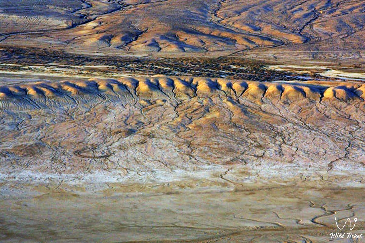
• Basin floor with takyr salt flats – an extensive flat central bowl covered by a mosaic of clay takyrs with geometric desiccation cracks and patches of self-precipitated salt, transforming in spring into a shallow reflective lake.
• Rock towers and weathering outliers – erosional limestone pillars, cornices, and jagged crests detached from the bedrock massif of the plateau through gravity and wind action.
• Panoramic eastern viewpoint headland – a natural promontory along the plateau rim providing a 360-degree vista across the entire Basgurly basin, the neighboring Zhazgurly depression, and the distant belt of Karynzharyk sands.
• Karst niches and cave grottoes – shaded half-caves in the middle tier of limestone cliffs that serve as natural nesting shelves for raptors and daytime resting spots for mouflons.
• Seasonal runoff says – deep, winding stony dry beds at the junction of the plateau and the basin floor through which rushing meltwater flows in spring, revealing clusters of fossils from the ancient Tethys Ocean.
Flora and fauna
The plant life of the Basgurly depression is clearly differentiated across altitudinal and soil zones. The gravel rims of the plateau and upper terraces are dominated by drought-resistant dwarf subshrubs: gray-soil wormwood, Lerche's wormwood, Anabasis salsa (biyurgun), boyalych, eastern saltwort, and Krascheninnikovia (teresken). Rare calciphytic species grow upon sheer rocks and scree slopes of the chink: Malacocarpus crithmifolius, Atraphaxis, Convolvulus persicus, and crustose lichens.
Specialized halophytic communities form across the saline floor of the depression: Halocnemum strobilaceum, European glasswort, Caspian Kalidium, and Schober's nitre bush. In spring, the slopes and sandy-gravel aprons come alive, carpeted with wild Sogdian tulips, two-flowered tulips, irises, and small ephemerals that wither by early summer.
The wildlife of the basin enjoys protection of republican significance and exhibits exceptional richness of rare species. Steep scarps of the chink harbor a population of the Ustyurt mountain sheep (mouflon / urial), which relies on rocky ledges to evade wolves. Graceful goitered gazelles graze across the flat floor and surrounding plateau, with migrating bands of saigas passing through in spring.
The avifauna includes rare species listed in the Red Book of Kazakhstan. The cautious MacQueen's bustard (houbara bustard) nests along the clay-gravel slopes of the plateau. In the niches of limestone cliffs, saker falcons, peregrine falcons, golden eagles, steppe eagles, long-legged buzzards, Egyptian vultures, and eagle-owls rear their young. Black-bellied sandgrouse, Pallas's sandgrouse, desert larks, and stone-curlews are common across the floor.
Among mammals inhabiting crevices and burrows are the sand cat, caracal, steppe polecat, marbled polecat, corsac fox, tolai hare, long-eared hedgehog, Brandt's hedgehog, along with colonies of gerbils and jerboas. Wolves and jackals patrol the basin at night.
The herpetofauna is represented by the desert monitor, Central Asian tortoise, toad-headed and secret toad-headed agamas, steppe agama, sand boa, arrow snake, four-lined snake, and the venomous Halys pit viper. Scorpions, solifuges, and black widow spiders (karakurt) dwell under stones.
Legend
An ancient Kazakh legend concerning the Batyr's Stone Shield and the Sultan's Arrow is linked to the origin of the Basgurly depression.
Tradition tells that in times when the encampments of Mangyshlak faced raids by fierce foreign invaders, a brave batyr named Basgur lived on the plateau. Endowed with heroic strength and a steadfast heart, he guarded peaceful auls grazing sheep in the valleys of Kenderli.
One morning at dawn, sentinels spotted the countless host of an enemy khan marching across the plateau to seize women and capture horse herds. Batyr Basgur stepped forward alone to meet the foe, taking up a defensive stand at the edge of the plain. In the fierce clash, the batyr deflected hundreds of arrows, but the enemy khan loosed an enchanted black arrow that struck the warrior in the heart.
Falling upon his native soil, Basgur summoned his remaining strength to strike his heavy battle shield against the hard limestone of the plateau, calling upon the spirits of his ancestors: "Let this earth open up and hide our sacred pastures from enemies forever!" From the tremendous blow of the shield, the ground shook and split apart, opening a bottomless basin with sheer rocky walls that swallowed the invaders' cavalry.
The hero's body dissolved into the limestone cliffs, turning into the impregnable bastions of the chink, while the depression he struck out became a dependable haven for nomads and wild beasts. Ever since, people have named this tract Basgurly in memory of the faithful protector of the steppe, believing the batyr's spirit continues to safeguard the peace of the quiet valley.
Conclusion
The Basgurly depression is an untouched, rugged natural monument of Mangystau, where cyclopean limestone cliffs meet the silence of a salt-flat floor and primeval desert life. An expedition to the sheer chinks of Basgurly offers the traveler an unforgettable sense of discovery, revealing the deep chronicle of the ancient Tethys Ocean, the soaring flight of noble falcons, and the authentic power of Kazakhstan's wild nature.
Interesting sights nearby:
• Kenderli-Kayasan State Nature Sanctuary;
• Kenderli-Kayasan Limestone Plateau;
• Neighboring endorheic Zhazgurly (Zhasgurly) depression;
• Kauyndy (Kuandy) Endorheic Depression;
• Rocky chinks of Kulandy and Kayasanirek;
• Karynzharyk Endorheic Depression spanning 85 km;
• Kenderli Salt Flat (Kendirlisor);
• Onere Chalk Outliers ("Three Brothers");
• Karamaya Dark Outlier Mountain Ridge;
• Senek (Tuyesu) Sand Massif and Dunes;
• Ustyurt State Nature Reserve;
• Oil Town of Zhanaozen.
Sacred sights and pilgrimage destinations:
• Beket-Ata Underground Mosque in Oglandy Tract;
• Shopan-Ata Underground Mosque in Karakiyan District;
• Karaman-Ata Underground Mosque and Necropolis;
• Mausoleum of Saint Man-Ata on Manata Pass;
• Shakpak-Ata Rock-Cut Cruciform Mosque;
• Sultan-Epe Underground Mosque and Necropolis;
• Kenty-Baba Necropolis and Underground Mosque;
• Khanga-Baba Necropolis with Ancient Stone Mosque;
• Pantheon of Kazakh Batyrs Sisem-Ata Necropolis;
• Ancient Koshkar-Ata Necropolis;
• Otpan Tau Historical and Cultural Complex on Mount Otpan-Tau;
• Masat-Ata Underground Cave Mosque.
Photogallery: