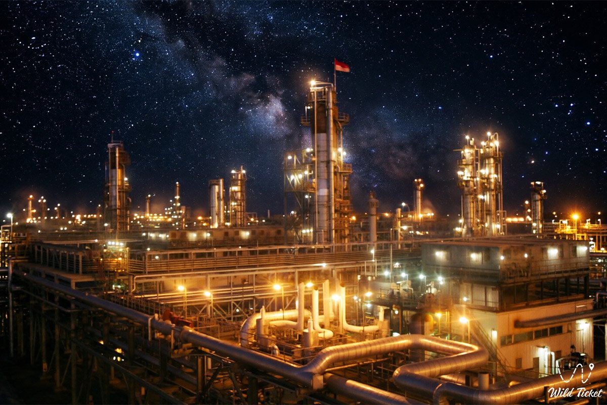
Colossal subsalt hydrocarbon reserves and unique ultra-high reservoir pressure –
The Tengiz Oil and Gas Field (Kaz. Tengiz munai ken orny) represents an onshore supergiant complex in western Kazakhstan, unique in its physical scale and recoverable reserves. This vast hydrocarbon field is situated in the southern part of the Pre-Caspian Basin at the junction of the Zhylyoi district of the Atyrau region, roughly 350 kilometers southeast of the city of Atyrau and in immediate proximity to the northern shoreline of endorheic Lake Sarykamys.
This expansive lowland territory serves as a vital industrial heartland of the nation alongside the Kashagan field, where boundless semi-desert steppes exist beside advanced operational facilities of the international petroleum sector. For hundreds of kilometers around stretch open terrains where the sharp continental climate of the Caspian basin shapes the operational tempo of thousands of engineers and drilling specialists.
In the transit and logistical framework of western Kazakhstan, the development of the Tengiz field established a robust network of motorways and rail links connecting the production complex with coastal ports and logistical hubs across the Mangystau region. Through the town of Kulsary and the junction station of Makat, hydrocarbon streams and heavy industrial machinery move south toward the shores of the Caspian Sea, the international commercial Port of Aktau, marine support bases on the Tupkaragan Peninsula, the plateaus of Mangyshlak, sacred Mount Otpan-Tau, and maritime gateways on the Caspian.
The geological basement of the field lies at record depths (from 3.8 to 5.4 kilometers) and consists of a thick massif of Devonian and Carboniferous carbonate reef deposits formed hundreds of millions of years ago at the bottom of the vanished ancient Tethys Ocean, sealed securely by an overarching salt dome canopy.
From Tengiz facilities, overland routes lead researchers and travelers to distinctive natural monuments of neighboring regions: to the chalk chinks of the Bozzhira tract, the Tuzbair salt flat, Mount Bokty, the Karynzharyk depression, and the sweeping reaches of the Ustyurt Nature Reserve.
The primary technological feature of the project is the industrial plant complex operated by Tengizchevroil (TCO), which includes modern Second Generation Plants (SGP) and the Future Growth Project - Wellhead Pressure Management Project (FGP-WPMP). Crude oil produced on site undergoes complex multistage separation, capturing sour gas streams and reinjecting them back into the reservoir under high pressure.
After concluding work shifts on the installations at Tengiz, specialists frequently embark on journeys across historical landmarks of Mangystau – to the Shakpak-Ata underground mosque (UNESCO site), the Tamshaly gorge, the Zhygylgan sinkhole, and the coast of Sarytas Bay.
Today, the Tengiz field is recognized as one of the most technically challenging and economically consequential onshore supergiant fields on the planet. The complex draws the interest of international energy experts, environmental scientists, and engineers through high production rates, closed-cycle environmental practices, and its structural role across Eurasian export corridors.
--------------------------------------------
Geography, logistics, and transit corridors –
The Tengiz field is situated in the southern part of the Pre-Caspian Lowland, within a flat semi-desert zone of the Atyrau region, roughly 25–30 kilometers east of the shoreline of the Caspian Sea and near salt flat basins. Surface elevations sit below global sea level (around -10 to -20 meters). The road distance to the regional administrative center of the city of Atyrau is approximately 350 km to the northwest, and roughly 75–80 km to the nearest urban center of Kulsary.
GPS geographical coordinates of the Tengiz field:
46°10'12"N 53°23'36"E
Controlled access zone and security protocols: the Tengiz field is a strategic industrial facility subject to strict occupational health, safety, and environmental regulations. Entry into the oilfield territory, residential rotation camps, and TCO operational plants is strictly regulated and permitted exclusively for accredited personnel, contractors, and authorized delegations holding official passes. Unrestricted access for general tourists and unauthorized private vehicles is prohibited.
Logistical connections with Mangystau and the Caspian: Tengiz is integrated into the transport and supply network of western Kazakhstan:
– Rail junctions of Kulsary and Makat stations – key transfer points for heavy plant modules, drill pipe, and processing chemicals arriving from northern and southern hubs, including freight transiting through the Mangystau region.
– Highway Atyrau – Kulsary – Beyneu – the primary road link connecting Tengiz operations with the Mangystau region and onward to border crossings into Uzbekistan and Turkmenistan.
– CPC export pipeline system (Caspian Pipeline Consortium) – from Tengiz originates a trunk pipeline extending over 1,500 kilometers, connecting the inland field with the marine export terminal near Novorossiysk on the Black Sea to move the bulk of Kazakhstan's crude exports.
Camp town infrastructure: Tengiz operates as an autonomous industrial community with comprehensive municipal services. Facilities include residential complexes for rotation personnel, medical clinics, fire stations, dedicated power generation plants, dining facilities, sports complexes, and Tengiz International Airport handling charter flights for engineering and management staff.
Climatic conditions: the oilfield zone has a sharply continental, arid climate. Summers are hot and dry, with July temperatures frequently exceeding +40...+42 °C alongside dust storms and desiccating winds (sukhovey). Winters are moderately cold and breezy, averaging -8...-12 °C in January, characterized by blizzard conditions and deep soil freezing.
--------------------------------------------
History
The history of discovery and development at the Tengiz field is an epic page in Soviet and Kazakhstani petroleum geology, representing a triumph of engineering thought.
Exploration drilling on the Tengiz structure commenced in the late 1970s under Soviet geological teams. The defining historical date arrived on December 19, 1979, when exploration well No. 37 struck a high-yield oil reservoir at a depth exceeding 4 kilometers. Driven by reservoir pressure over 800 atmospheres, the well suffered a blowout, erupting into an uncontrolled plume of burning oil, gas, and hydrogen sulfide. Containing the emergency and capping well No. 37 demanded dedicated engineering efforts and specialized pressure-control operations, requiring over a year of continuous containment work.
Following Kazakhstan's independence, in April 1993, the national government established the Tengizchevroil (TCO) joint venture with national operator KazMunayGas alongside American energy corporations Chevron and ExxonMobil (with Lukoil and Shell joining the partnership later). This agreement became sovereign Kazakhstan's first major long-term joint venture with international energy firms.
Over the subsequent decades, TCO transformed Tengiz into a modern operational asset. Teams erected the Second Generation Plant (SGP), sulfur processing facilities, and completed the Future Growth Project (FGP) to raise annual processing capacity.
Geological phenomenon and unique reservoir pressure
Tengiz is considered one of the world's most demanding fields to develop due to its geological depth and physical fluid parameters.
Hydrocarbons reside in a massive ancient reef buildup formed by calcareous organisms and algae on the bed of a Devonian ocean. The vertical thickness of the productive carbonate section reaches hundreds of meters. A defining attribute of the reservoir is its enclosed hydrodynamic structure, isolated beneath a thick regional salt canopy.
Abnormally High Formation Pressure (AHFP): bottom-hole pressures at Tengiz reach 800–850 atmospheres, with reservoir temperatures around +85...+105 °C. Managing these downhole conditions requires high-tensile steel casing strings, specialized wellhead valves, and redundant blowout prevention systems.
High hydrogen sulfide content (H2S): associated petroleum gas and the crude oil itself contain high fractions of toxic hydrogen sulfide (up to 16-17%). This necessitated closed separation units, plant facilities for elemental sulfur recovery, and strict safety guidelines for operating crews. Tengiz produces high-purity granular sulfur shipped to global agricultural and chemical manufacturing markets.
Detailed description of the venue
The industrial and support network at Tengiz includes the following technological installations:
• Second Generation Plant (SGP) – an integrated processing complex for oil stabilization, gas processing, and sweetening through hydrogen sulfide removal.
• Future Growth Project facilities (FGP-WPMP) – modern processing units designed for high-pressure sour gas reinjection into the reservoir to maintain reservoir drive.
• Well inventory of the supergiant – a network of deep, high-flow production wells equipped with automated surface monitoring and safety shutoff valves.
• Sulfur recovery units and storage blocks – dedicated processing trains that convert extracted hydrogen sulfide into solid, low-dust elemental granular sulfur.
• Shift camps and Shanyrak village – self-contained residential complexes providing accommodation, catering, and medical support for thousands of workers.
• Tengiz logistics hub – a comprehensive system of rail yards, roads, and a dedicated certified airfield.
Environmental management and technical safeguards
Environmental policy at the Tengiz field adheres to strict international standards. Operations follow a routine zero-flaring mandate: surplus associated gas is captured, sweetened, and either reinjected into the formation or utilized for on-site power generation.
Automated air quality monitoring networks function around the clock across the sanitary buffer perimeter and in nearby residential communities. Sensors register shifts in ambient gas levels to protect operating staff and the local semi-desert ecosystem.
Sulfur handling receives specific focus: modern granulation methods permit safe transport and containerized shipment without fine dust emissions. In surrounding areas of the Caspian basin, project operators finance regional biodiversity initiatives, studies on migratory bird movements, and ecological research across the steppe.
Legend
A modern regional legend concerning the Flaming Fountain and the Sleeping Dragon of the Deep is told in connection with the Pre-Caspian steppes and the discovery of Tengiz.
Lore relates that deep beneath the salt canopy of the Pre-Caspian Basin, within the dark chambers of the ancient Tethys Ocean, slept a primeval fire dragon guarding treasures of the earth. For centuries, nomadic pastoralists skirted these quiet salt flats, perceiving the warm subterranean breath and low tremors issuing from below.
Elders said a day would come when humankind would seek the keys to the dragon's vaults, yet mastering that energy would require steadfast resolve, duty, and clear knowledge. In December 1979, when well No. 37 broke through the ancient salt barrier and an immense flare rose into the winter sky, local elders recalled the old prophecy, seeing in it the awakening of the underground guardian.
It took the concerted efforts of experienced engineers to cap the well and harness that energy for constructive development. Ever since, lore across the Caspian steppe maintains that the fire of Tengiz represents creative industrial energy, directed through technical skill, scientific study, and collective labor.
Conclusion
The Tengiz field is a major asset in global energy supply and an industrial pillar of Kazakhstan, reflecting the work of geological teams, modern engineering designs, and significant long-term investments. Reviewing the history, technical setup, and transit logistics of Tengiz provides insight into the industrial landscape of the republic, linking the vast steppes of the Caspian basin with marine export channels and commercial corridors across Eurasia.
Interesting sights nearby:
• Regional Center City of Atyrau;
• Aktau International Sea Commercial Port;
• Otpan-Tau Memorial Complex;
• Shakpak-Ata Underground Mosque;
• Shakpaktysay Canyon;
• Snow-White Kapamsay Canyon;
• Zhygylgan Sinkhole;
• Tamshaly Gorge;
• Torysh Valley of Stone Balls;
• Oil town of Kulsary;
• Lake Sarykamys and salt flat landscapes;
• Marine support base in Bautino Bay.
Sacred sights and pilgrimage destinations:
• Shopan-Ata Underground Mosque;
• Beket-Ata Underground Mosque;
• Sisem-Ata Necropolis;
• Karaman-Ata Mosque;
• Sultan-Epe Mosque;
• Yerzhan Khazret Mausoleum;
• Koshkar-Ata Necropolis;
• Ushkan-Ata Necropolis.
Photogallery: