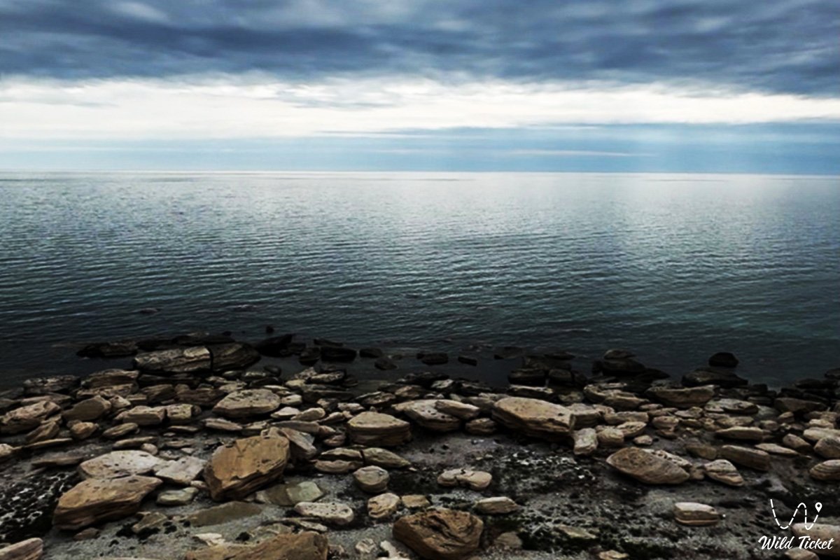
Rocky terraces of Kenderli Bay and maritime bastion of Mangyshlak –
Cape Tokmak (Kaz. Toqmaq muiisi) represents a rocky limestone headland jutting prominently into the waters of the Caspian Sea, a natural geomorphological barrier, and a scenic coastal landmark situated in the Karakiyan district of Kazakhstan. The cape juts deeply into marine waters along the southwestern coast of the Mangyshlak Peninsula, separating the open waters of the Caspian from the shallow, semi-enclosed Kenderli Bay and forming an expressive coastal arc alternating between precipitous cliffs, stone benches, and wild sandy beaches.
In the travel logistics of the Southern Cluster of Mangystau, Cape Tokmak serves as a prime coastal destination for enthusiasts of wild camping, sea angling, and littoral expeditions. Just 10–15 kilometers northeast of the headland stretches the year-round Kenderli resort complex, complete with developed hotels and a sandspit. Journeying north from the cape along the coastal highway brings travelers to the village of Kuryk with its modern Port Kuryk ferry terminal, a therapeutic radon spring, and the colossal tectonic depression of Karagiye (-132 m).
Heading east from Cape Tokmak's coast through the city of Zhanaozen unlocks direct expedition routes to the golden sand dunes of Senek (Tuyesu), the stepped scarps of the Kenderli-Kayasan Plateau, the Kenderli-Kayasan nature sanctuary, the Basgurly – Zhazgurly depression system, as well as the snow-white chalk chinks of the Bozzhira tract, the banded Mount Bokty, the Karynzharyk depression, and the Ustyurt Reserve.
The entire coastal morphology of the headland is a direct geological witness to the ancient Tethys Ocean and Late Quaternary transgressions of the Caspian basin. For millennia, waves of the Caspian undercut dense strata of Sarmatian coquina limestone, carving out a stratified abrasional scarp with grottoes, wave-cut notches, and extensive submerged rocky benches (reefs) that run into the sea.
The headland received its name from its characteristic clubbed, wedge-like shape (Kaz. "toqmaq" – mallet, wooden hammer, or pestle), which accurately mirrors the silhouette of the rocky promontory on topographic maps.
Today, Cape Tokmak is recognized as one of the most expressive and secluded coastal destinations along the Karakiyan coast, drawing overland travelers with crystal-clear emerald water, spectacular sunset panoramas over the Caspian, and the unbridled spirit of the sea.
--------------------------------------------
How to get there and visit –
Cape Tokmak is located on the southwestern coast of the Mangyshlak Peninsula, at the northwestern entrance to Kenderli Bay. The distance from the city of Aktau to the cape is roughly 210–220 km, from the district seat in the village of Kuryk it is about 140–150 km, from the city of Zhanaozen it is around 70–75 km, and from the Kenderli recreation zone it is just 12–15 km.
GPS geographical coordinates of Cape Tokmak:
42°47'16"N 52°17'30"E
The primary driving route from Aktau leads southeast along the paved republican highway through the Karagiye depression to the city of Zhanaozen (about 150 km). From Zhanaozen, the route continues southwest along the well-surfaced paved Zhanaozen – Kenderli highway (about 65 km), leading straight toward the seacoast. A few kilometers before the main entrance gate to the Kenderli resort area, turn right onto a hard-packed gravel-and-sand grader track that hugs the coastline directly toward the rocky cliffs of Cape Tokmak (about 12–15 km along the dirt road).
An alternative itinerary is the coastal route from Aktau through the village of Kuryk via paved highway, from where technical graders and coastal ruts lead south to Cape Tokmak along the Caspian shoreline. This option is longer and more rugged, but it rewards travelers with views of untamed coves.
For driving out onto the cape itself and traversing the shoreline, a crossover or high-clearance four-wheel-drive vehicle (4x4) is recommended. The approach to the rocky promontory passes across limestone slabs, weathered gravel stretches, and loose littoral sand.
Exercise caution near cliff edges: limestone cornices are subjected to wind and wave undercutting and can give way under foot. To avoid punctures from sharp coquina stones, carry an air compressor and a dependable spare wheel.
Visiting regime: Cape Tokmak is an open, publicly accessible recreation area. Special entry permits are not required; however, owing to proximity to Kazakhstan's maritime state border on the Caspian, travelers must keep an original passport or identity card on hand for potential border patrol checks.
Infrastructure directly on the headland is non-existent: untouched wilderness reigns here. The nearest hotels, groomed beaches, restaurants, and medical stations are located in the Kenderli resort area (a 15-minute drive). Brand-name gas stations, vehicle workshops, supermarkets, and ATMs are available in Zhanaozen. Mobile reception and 4G internet from major Kazakh providers operate reliably across elevated sections of the cape thanks to base stations in the nearby resort cluster.
The best season to visit is from late May through mid-September, when sea temperatures in Kenderli Bay and around Cape Tokmak warm to a comfortable +23...+26 °C, and dry, sunny weather creates optimal conditions for beach recreation, snorkeling, and camping under the stars. Spring (April – May) and autumn (September – October) are prime for landscape photography, bird-watching, and coastal angling.
--------------------------------------------
History
The history of Cape Tokmak encompasses centuries of navigation and fishing on the Caspian Sea. Situated at the mouth of calm Kenderli Bay, the rocky promontory historically served as a natural beacon for mariners and a breakwater damping the heavy swell of the open sea.
In the Middle Ages, the coastal cliffs of the cape provided seasonal shelters for boats belonging to nomadic clans and fishermen. Stone Age (Neolithic) flint tools have been identified across the level plateau terraces, along with remnants of medieval stone corrals and seasonal fishing camps. Nomadic caravan paths skirting inland salt marshes reached the headland to harvest fish and marine game.
During the 18th and 19th centuries, the waters of Cape Tokmak and Kenderli Bay formed a traditional theater for fishing and seal hunting by the Aday Kazakhs. In autumn, large haul-outs of Caspian seals formed on the shallow stone reefs ringing the promontory, attracting coastal hunting cooperatives.
In the mid-20th century, hydrographers of the Caspian Flotilla erected navigational markers on the elevated crest of the cape to guide maritime approaches to fishing grounds and moorings in Kenderli Bay. Geologists and geomorphologists systematically documented the karst-abrasional framework of the headland during comprehensive surveys of the Southern Mangyshlak shelf.
In modern times, following the construction of the neighboring Kenderli resort complex, Cape Tokmak became a destination for eco-tourists, spearfishing enthusiasts, and campers seeking pristine beaches on Mangystau.
Information
Geomorphologically, Cape Tokmak is a denudational-abrasional rocky headland of a structural bedded plateau, extending out into the open sea for more than 2–3 kilometers. The height of the coastal scarp ranges from 5 to 15–20 meters above the waterline, stepping down toward its southern tip through structural terraces. The shoreline is dissected by wave-cut notches, micro-coves, and submerged benches (abrasion platforms) reaching dozens of meters into the sea.
The geological section is composed of Upper Miocene (Sarmatian regional stage) marine carbonate rocks formed on the seabed of the ancient Tethys Ocean. Exposed along the coastal scarps are horizontal beds of dense oolitic limestones, yellowish-gray coquinas, and marls, capped by thin horizons of loams and windblown sands. Fossils of prehistoric marine fauna are common throughout the weathering limestone slabs: cardiid bivalve shells, gastropod casts, and shark teeth.
Soil cover is minimally developed: primitive gravelly gray-brown desert soils occur on the elevated flat, while marine sands with coquina shell fragments and saline silts cover the littoral zone.
Hydrological characteristics are determined by the hydrodynamic regime of the Caspian Sea. Water around Cape Tokmak is noted for high clarity (visibility up to 6–8 meters) and low turbidity due to the rocky bottom and absence of river runoff. Depths drop off quickly along the cliffed flanks, reaching 4–7 meters just tens of meters from shore, whereas the leeward eastern flank inside the bay shelves gently into sandy flats. Currents around the headland follow wind-driven circulatory patterns.
The climate is temperate desert, arid, and regulated by the thermal mass of the Caspian Sea. In summer, average daytime air temperatures measure +28...+32 °C (peaking up to +38 °C), though heat is moderated by steady sea breezes. Winters are mild and cool, averaging around -1...+2 °C, although storm gales can reach speeds of 20–25 m/s. Annual precipitation does not exceed 130–140 mm.
Detailed description of the venue
The natural landscape complex of Cape Tokmak encompasses the following distinct sectors, viewing decks, and coastal features:
• Rocky cornices and scarps of the western face – sheer limestone ramparts up to 15 meters high bearing the impact of open Caspian waves, undercut by sea grottoes and wave-washed cavities.
• Headland plateau with scenic observation point – an elevated flat terrace at the crest of the cape providing sweeping 360-degree vistas across the open marine horizon to the west and the turquoise surface of Kenderli Bay to the east.
• Submerged rocky reef (Tokmak reefs) – a system of drowned limestone slabs and boulders providing habitat for schools of mullet and acting as a prime dive site for spearfishing.
• Eastern leeward sandy lagoon – a sheltered cove protected from prevailing winds, featuring golden crushed-shell sand and clear, calm, warm water suitable for swimming and pitch camping.
• Headland navigational beacon – a historic hydrographic tower set at the highest point of the cliff, serving as a landmark for small vessels and motorboats.
• Wave-carved rock tidal pools – natural hollows within the coquina shoreline shelves where seawater collects during surges, warming under the desert sun.
Flora and fauna
The vegetation cover of Cape Tokmak exhibits a distinctly arid-littoral character. The stony plateau and sandy terraces support salt- and drought-tolerant species: gray-soil wormwood, Lerche's wormwood, boyalych, Anabasis salsa (biyurgun), eastern saltwort, Russian saltwort, saltbush, and sea rocket. Individual clumps of tamarisk and camelthorn (dzhantak) occur in shallow micro-depressions. In spring, the coastal steppe is briefly covered by green carpets of ephemerals, wild steppe alliums, and two-flowered tulips.
Fauna on the headland is tied to the marine life of the Caspian basin. The endemic Caspian seal is a regular visitor along rocky reefs and shoals: during spring and autumn, solitary animals and small pods can be observed resting on rocks or hunting fish. The ichthyofauna is diverse: schools of Caspian mullet (singil), gobies, wild carp, Caspian roach, pike-perch, and herring dwell in these waters, while sturgeon species (stellate sturgeon, Russian sturgeon) migrate through deeper offshore channels.
Avifauna along the shore includes large colonies of sea birds. Caspian gulls, Pallas's gulls, common terns, and great cormorants wheel over the cliffs, diving for fish among littoral boulders. Grey herons, waders, and common shelducks feed along the sandy shallows of the lagoon. During migratory seasons, flocks of mute swans and greater flamingos stage on the bay waters flanking the promontory.
Terrestrial mammals in the surrounding steppe include the corsac fox, tolai hare, steppe polecat, long-eared hedgehog, and gerbils.
Herpetofauna is represented by the agile steppe agama, toad-headed agama, rapid fringe-toed lizard, arrow snake, dione snake, and four-lined snake. Solifuges and tarantulas shelter beneath sun-warmed rocks.
Legend
An ancient Kazakh legend concerning the Batyr Blacksmith and the Sea Giant is tied to Cape Tokmak.
Tradition tells that when the Aday clans first arrived along the shores of Mangyshlak, a ferocious sea giant began emerging from the depths. He raised towering waves, shattered fishing skiffs, and raided nomadic encampments, demanding tribute in the finest stallions from their herds.
Rising to protect his kin was a mighty steppe blacksmith and batyr. In his forge, using celestial meteoric iron, he hammered out a colossal war hammer – a toqmaq – whose weight and hardness had no equal on earth. Taking the weapon in hand, the batyr walked to the cliff edge and challenged the sea giant to single combat.
When the monster rose from the depths, casting a wall of brine against the shore, the warrior struck the coastal rock with his hammer. From that blow, lightning flashed across the sky, the waters parted, and the giant was cast down into a subterranean chasm. Yet in that decisive strike, the batyr poured out his life force, turning to eternal stone on the shoreline alongside his hammer.
Ever since, nomads have called this rocky headland, shaped like a colossal hammer, Cape Tokmak. Elders tell that the warrior's stone hammer still seals the ocean deep, shielding coastal auls and the bay from the destructive fury of the Caspian Sea.
Conclusion
Cape Tokmak is an expressive natural bastion of Southern Mangyshlak, where the raw power of the Caspian surf meets the golden sands of secluded lagoons and the quiet expanse of the maritime horizon. An expedition to its rocky terraces rewards visitors with pristine sea waters, glimpses of Caspian seals, and fiery sunsets across the ancient soil of Mangystau.
Interesting sights nearby:
• Shallow Kenderli Bay;
• Kenderli Resort Area;
• Coastal Village of Kuryk;
• Ferry terminal of the international Port Kuryk;
• Warm mineral radon spring near Kuryk;
• Town of Fort-Shevchenko;
• Village and Port of Bautino;
• Deepest Karagiye Depression (-132 m);
• Lake Karakol, Home of Greater Flamingos;
• Sand Massif and Dunes of Senek (Tuyesu);
• Karynzharyk Depression and Chalk Outliers "Three Batyrs" of Onere;
• Kenderli Salt Flat (Kendirlisor);
• Cape Peschany on the Caspian coast;
• Picturesque rocky Kamysbay Gorge;
• Coastal sandspit and Lake Saura;
• Rocky Tamshaly cove with spring;
• Oil City of Zhanaozen.
Sacred sights and pilgrimage destinations:
• Beket-Ata Underground Mosque in Oglandy Tract;
• Shopan-Ata Underground Mosque in Karakiyan District;
• Karaman-Ata Underground Mosque and Necropolis;
• Mausoleum of Saint Man-Ata on Manata Pass;
• Shakpak-Ata Rock-Cut Cruciform Mosque;
• Sultan-Epe Underground Mosque and Necropolis;
• Kenty-Baba Necropolis and Underground Mosque;
• Otpan Tau Historical and Cultural Complex on Mount Otpan-Tau;
• Masat-Ata Underground Cave Mosque.
Photogallery: