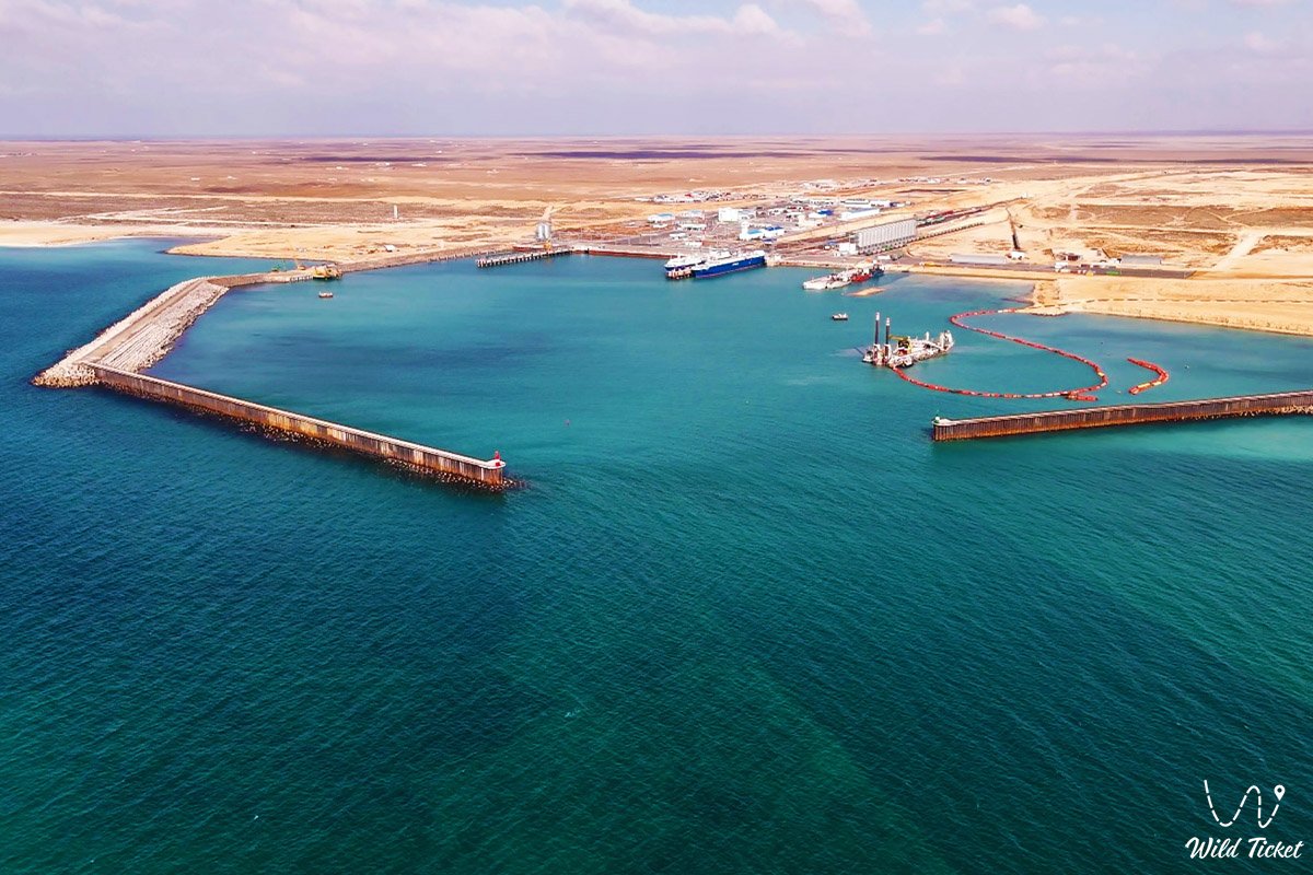
Port Kuryk (Ferry Complex)
Trans-Caspian maritime gateway of Kazakhstan and deep-water outpost on the Caspian Sea –
Port Kuryk (ferry complex) – (Kaz. Quryq portynyn paromdyq kesheni) represents an ultra-modern deep-water seaport of year-round navigation, a strategic transport and logistics hub, and a prominent asset of modern transport infrastructure located in the Karakiyan district in Kazakhstan.
The port is situated on the eastern coast of the Caspian Sea in the natural deep-water basin of Aleksandrbay Gulf (Kuryk Bay), in close proximity to the seaside village of Kuryk and approximately 70–75 kilometers south of the regional center Aktau.
In the tourism and expedition logistics of the Southern cluster of Mangystau, the ferry complex serves as a critical industrial landmark and a convenient connecting link between maritime and overland routes. Just a 40–50 minute drive northeast of the port begins the descent into the grandiose endorheic Karagiye depression (-132 meters below sea level) with the dazzling Batyr salt flat. Not far from here lies Lake Karakol (home of greater flamingos). Traveling south from the port zone along the shoreline, travelers reach the picturesque wild crags of Cape Tokmak, the calm waters of Kenderli Bay, and the year-round hotel complexes of the Kenderli resort.
The port's location relies on unique natural and geological features of the coast, shaped by the retreat of the ancient Tethys Ocean and Late Quaternary marine terraces of the ancient Caspian. Sheltered from northwesterly winds, the water area with natural depths of up to 8–10 meters along approach channels does not freeze in winter, ensuring uninterrupted navigation year-round.
From here, through the key oil city of Zhanaozen, direct off-road routes open to the golden dunes of the Senek (Tuyesu) sand massif, the stepped scarps of the Kenderli-Kayasan Plateau, the Kenderli-Kayasan nature sanctuary, and the ancient relict depression system of Basgurly – Zhazgurly.
For travelers on large-scale transit journeys across Central Asia and the Caucasus, Port Kuryk serves as the primary maritime gateway, providing regular ferry connections with Azerbaijan. Prior to ferry departures toward the Baku port of Alat or after disembarking onto the Mangyshlak shore, tourists head out on self-contained expeditions to the cyclopean chalk canyons of the Bozzhira tract, the banded Mount Bokty, the boundless snow-white sors of the Karynzharyk depression, and the impregnable chinks of the Ustyurt Reserve. It is also possible to drive to Mount Sherkala, where ancient fossils can be found.
For lovers of industrial aesthetics, the Port Kuryk ferry complex provides a unique waypoint: people come here to behold the monumental panorama of giant breakwaters reaching out into the open Caspian, watch sea ferries set sail in the rays of the setting sun, catch dawn along secluded sand-and-shell coastal spits, and observe Caspian seals playing near the breakwaters.
--------------------------------------------
How to get there and visit –
The Port Kuryk ferry complex is situated on the eastern shore of the Caspian Sea in the waters of Aleksandrbay Gulf, roughly 17 km southwest of the residential area of the village of Kuryk, Mangystau region. The distance from the city of Aktau is around 70–75 km along a first-class paved highway, from the city of Zhanaozen it is about 125 km, and from the Yeraliyev railway junction station it is 25 km.
GPS geographical coordinates of the Port Kuryk ferry complex:
43°09'40"N 51°26'38"E
The road route from Aktau leads south along the high-speed paved republican highway Aktau – Kuryk, branching off along a modern wide motorway directly to the port terminals. The road is maintained in excellent condition year-round, requiring a drive of about 50 minutes in a standard car.
From the city of Zhanaozen, driving is via the paved highway Zhanaozen – Zhetybay – Kuryk or along a dedicated direct route linking the oil and gas district with the port area.
The ferry complex is integrated into the national railway network via the specially constructed 14-kilometer Borzhakty – Yersay rail link, connecting the port berths with the mainline railway Beyneu – Zhanaozen.
For overland travelers and road-trippers traveling with their own cars, motorcycles, or campervans (motorhomes) across the Caspian Sea to Baku (Port of Alat) or arriving in Kazakhstan, the port provides a full range of customs and border clearance services on a single-window basis. Ferry tickets are booked in advance through official electronic services of ferry operators or directly at ticket desks in the passenger terminal.
Visiting regime: the territory of the ferry complex is a guarded strategic zone of an international seaport subject to access control. Entry into berths and customs areas is allowed strictly with an international passport, ferry tickets, or an official pass issued by the port administration. Viewing the port from outside is possible from elevated coastal bluffs and sand-and-shell hills along Aleksandrbay Gulf.
Infrastructure of the port complex includes a modern administrative and passenger terminal, comfortable waiting lounges, a canteen, cafes, hotel accommodations for drivers and travelers, sanitary facilities with showers, ATMs, customs and border control checkpoints, and spacious secured vehicle staging lots. A 15–20-minute drive away in Kuryk village, brand-name gas stations, service stations, tire repair shops, supermarkets, a bazaar, and a hospital are available. High-speed 4G cellular coverage from Kazakhstan's major mobile operators functions reliably across the entire port area.
The port operates year-round on a 24/7 continuous schedule. The most comfortable period for travel and Caspian ferry crossings is from May through October, when calm sea weather predominates. During the autumn-winter season (November – February), brief departure delays may occur due to gales over the open Caspian.
--------------------------------------------
History
The establishment of the Kuryk ferry complex became a defining chapter in the transport modernization of independent Kazakhstan and the revival of the transcontinental Silk Road. The necessity of building a new deep-water ferry terminal south of Aktau was driven by surging cargo flows along the Trans-Caspian International Transport Route (TITR / "Middle Corridor") and the need for a dedicated terminal to process rail cars and wheeled vehicles.
In 2014, by directive of the national leadership, the master plan for creating a multimodal hub in Kuryk Bay within Aleksandrbay Gulf was approved. Site selection relied on natural hydrographic advantages: ample natural depths, reliable wave sheltering by sandy-rocky spits, and an absence of winter ice formation.
Construction started in 2015 with the laying of the Borzhakty – Yersay railway line, linking the coast to Kazakhstan's railway network. Capital hydrotechnical moles and breakwaters were erected rapidly, accompanied by extensive dredging operations. In December 2016, the first stage of the port was commissioned – a railway ferry complex capable of handling ferries carrying rail cars and tank wagons.
In August 2018, the port's second stage was put into operation – an automobile ferry terminal with a handling capacity of up to 20,000 trucks and trailers annually. The new terminal closed a strategic logistical loop between the dry port of the SEZ "Khorgos – Eastern Gate" on the Chinese border, the "Tazhen" customs post on the Uzbek border, and ports of the Caucasus and Europe.
Today, Port Kuryk continues to expand its cargo throughput, handling regular container trains, transit trucking convoys, and thousands of international road travelers, joining Asia and Europe.
Information
Morphometrically, the port basin is a deep-water engineered haven shielded from the open sea by massive stone breakwaters and moles. The total port area exceeds 65 hectares. Water depths along the access channel and alongside berths range from 7.5 to 9.5 meters, guaranteeing unobstructed berthing for RO-PAX and RO-RO vessels with deadweights up to 6,000–8,000 tons across seasonal fluctuations in Caspian water levels. The design capacity of the port exceeds 6 million tons of cargo per year (over 4 million tons via rail and around 2 million tons via automotive transport).
The geological basement of the shore is formed of Mesozoic and Cenozoic marine strata of the Tethys Ocean, mantled by dense Quaternary coquina limestones of the Sarmatian stage and Neo-Caspian marine sands. Geotechnical conditions allowed heavy berthing moles and hydraulic adjustable rail bridges to rest upon firm bedrock limestone foundations.
The hydrological regime of the basin is characterized by pronounced hydrodynamic stability. Unlike northern shallow Caspian gulfs, Aleksandrbay Gulf around Port Kuryk possesses continuous deep-water circulation and low turbidity. The water area is ice-free: winter water temperatures rarely drop below 0...+2 °C, preventing solid ice formation.
Technical equipment includes two dedicated hydraulic bridges for simultaneous servicing of two rail ferries, a roll-on/roll-off truck pier for automotive traffic, classification rail yards, automated inspection systems, and closed-loop wastewater treatment facilities.
The climate is temperate desert maritime. In summer, average daytime air temperatures measure +28...+32 °C under clear sunshine and sea breezes. In winter, average January temperatures range between -1 and -4 °C. Precipitation totals no more than 130–150 mm annually, while steady winds are attenuated by the port's massive protective breakwaters.
Detailed description of the venue
The infrastructural ensemble of the Port Kuryk ferry complex includes the following functional zones, marine structures, and operational sectors:
• Dual-track railway ferry bridges – hydraulic lift-and-transfer bridges that automatically adjust to ferry draft levels for safe roll-on/roll-off loading of rail wagons and platforms.
• RO-RO automotive terminal – a specialized pier with a broad loading ramp for direct roll-on boarding of heavy freight trucks, cars, motorcycles, and campervans.
• Western and Eastern protective breakwaters – massive stone moles constructed from interlocking concrete tetrapods and quarried stone, damping open-sea swell across the berthing basin.
• Administrative and passenger terminal building – a multi-story civic building housing passport control checkpoints, comfortable lounges, ticket desks, and a customs clearance hall.
• Vehicle staging and logistics lots – spacious guarded parking areas for customs inspection, holding, and convoy marshalling before vessel loading.
• "Port Kuryk" railway station – an extensive track layout equipped with shunting locomotives, weighing scales, and wheelset bogie adjustment facilities.
Flora and fauna
The plant life of the port buffer zone and adjacent coast consists of drought-resistant psammophytic and halophytic communities of coastal desert. Sand-and-shell berms and roadsides support Russian saltwort, saltbush, sea rocket, feather grass, and camelthorn (dzhantak). Elevated gravel terraces support clusters of gray-soil wormwood, Anabasis salsa (biyurgun), and boyalych. In sandy depressions outside the fenced perimeter, black saxaul and tamarisk shrubs grow.
The marine fauna of the adjacent Caspian Sea waters is subject to continuous environmental monitoring. The outer waters around the moles and deep bay serve as regular sighting areas for the endemic Caspian seal, which hunts fish near the stone riprap of the breakwaters. The local fish population includes schools of Caspian mullet (singil), pike-perch, wild carp, Caspian roach, herring, and gobies.
Avifauna along the coast comprises dozens of coastal and migratory bird species. Caspian gulls, Pallas's gulls, common terns, and great cormorants perch along the concrete parapets of the breakwaters and light towers. In the shallows of adjacent coves, waders, grey herons, and common shelducks forage. Flocks of mute swans and greater flamingos pass overhead during spring and autumn migratory seasons.
Terrestrial mammals inhabiting the surrounding semi-desert include the tolai hare, corsac fox, long-eared hedgehog, and gerbils. Goitered gazelles occasionally wander across the stony plains from the chinks of the Karagiye depression.
Herpetofauna is represented by the agile steppe agama, toad-headed agama, arrow snake, and dione snake. Solifuges and black widow spiders (karakurt) dwell in rock crevices outside port grounds.
Legend
A modern Mangystau legend concerning the Golden Ship and the Unfading Beacon of Hope is associated with the revival of this maritime harbor in Aleksandrbay Gulf.
Tradition tells that during the zenith of the Great Silk Road, a hidden haven existed where merchant caravels loaded with silk, lapis lazuli, and spices found anchorage. The harbor was kept by a wise elderly navigator who knew the secrets of celestial constellations and safe navigation channels.
When centuries of conflict settled over Mangyshlak and desert sands buried the trade routes, the elder buried a golden anchor in the bay before departing. He foretold that a day would come when peoples of the East and West would reach out to one another again; cyclopean stone breakwaters would rise in the quiet cove, and steel caravans would sail across the waves straight into the evening glow.
Elders in the village recount that when construction crews drove the first pilings of modern Port Kuryk, a rainbow arched over the sea and a golden gleam reflected from the seabed, signaling the dawn of a new maritime era. Today, the bright lights of the port berths are regarded across the steppe as the Unfading Beacon of Hope, guiding vessels through storms toward peace and prosperity.
Conclusion
The Port Kuryk ferry complex is a monumental symbol of modern Kazakhstan, where the maritime spirit of the Caspian basin unites with global logistics engineering. For overland travelers and members of transcontinental expeditions, the port serves as a dependable bridge linking the shores of Mangyshlak with the Caucasus, opening the path to the timeless heritage of the ancient Silk Road.
Interesting sights nearby:
• Coastal Kuryk Bay and Aleksandrbay Gulf;
• Coastal Village of Kuryk;
• Deepest Endorheic Karagiye Depression (-132 m);
• Cape Peschany (Sarzha);
• Scenic Cape Tokmak on the coast of the Caspian;
• Kenderli Seaside Resort Complex;
• Shallow Kenderli Bay;
• Sand Massif and Dunes of Senek (Tuyesu);
• Warm mineral radon spring near Kuryk;
• Coastal sandspit and Lake Saura;
• Oil City of Zhanaozen.
Sacred sights and pilgrimage destinations:
• Beket-Ata Underground Mosque in Oglandy Tract;
• Shopan-Ata Underground Mosque in Karakiyan District;
• Karaman-Ata Underground Mosque and Necropolis;
• Mausoleum of Saint Man-Ata on Manata Pass;
• Shakpak-Ata Rock-Cut Cruciform Mosque;
• Sultan-Epe Underground Mosque and Necropolis;
• Kenty-Baba Necropolis and Underground Mosque;
• Khanga-Baba Necropolis with Ancient Stone Mosque;
• Pantheon of Kazakh Batyrs Sisem-Ata Necropolis;
• Ancient Koshkar-Ata Necropolis;
• Otpan Tau Historical and Cultural Complex on Mount Otpan-Tau;
• Masat-Ata Underground Cave Mosque.
Photogallery: